The world in 200 BC
On 1 July 200 BC, IntMap’s historical map draws 118 names across the world. The borders for this date come from Cliopatria, Seshat Global History Databank (by year), then historical-basemaps — each drawn only where the records before it are silent. It also draws 90 outlines whose name the record does not give for this date.
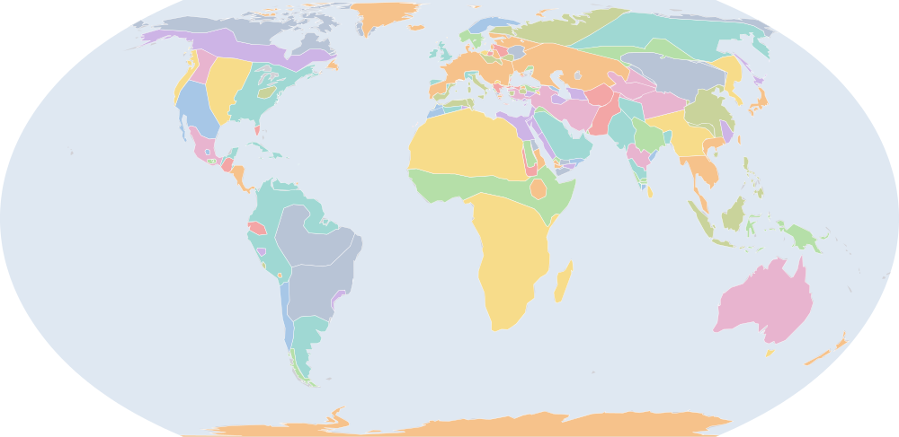
Why this year has a page
The historical-basemaps atlas drew a world sheet for this year.
Names on the map
As the map labels them, largest first by the area of the outline drawn. Areas are of the drawn outline, rounded, and approximate. The record column says which record draws the outline; a Wikidata item is given where the record links one.
| Name | Record | Drawn area (km²) |
|---|---|---|
| Khoiasan | historical-basemaps | 11,700,000 |
| Saharan Pastoral Nomads | historical-basemaps | 9,500,000 |
| Australian aboriginal hunter-gatherers (a description by the source, not a name) | historical-basemaps | 7,600,000 |
| Paleo-Siberian hunter-gatherers (a description by the source, not a name) | historical-basemaps | 7,170,000 |
| West African cereal farmers (a description by the source, not a name) | historical-basemaps | 6,000,000 |
| Arctic marine mammal hunters (a description by the source, not a name) | historical-basemaps | 5,910,000 |
| Manioc farmers (a description by the source, not a name) | historical-basemaps | 4,840,000 |
| Savanna hunter-gatherers (a description by the source, not a name) | historical-basemaps | 4,820,000 |
| Scythians | historical-basemaps | 4,810,000 |
| Xiongnu | Cliopatria · historical-basemaps Q188836 | 4,340,000 |
| Subarctic forest hunter-gatherers (a description by the source, not a name) | historical-basemaps | 4,330,000 |
| Amazon hunter-gatherers (a description by the source, not a name) | historical-basemaps | 4,280,000 |
| Finno-Ugric taiga hunter-gatherers (a description by the source, not a name) | historical-basemaps | 3,510,000 |
| Eastern North Amercian hunter-gatherers (a description by the source, not a name) | historical-basemaps | 3,340,000 |
| Plain bison hunters (a description by the source, not a name) | historical-basemaps | 2,820,000 |
| Yuezhi | Cliopatria · historical-basemaps Q467985 | 2,660,000 |
| Desert hunter-gatherers (a description by the source, not a name) | historical-basemaps | 2,350,000 |
| Seleucid Empire | Cliopatria Q705904 | 2,280,000 |
| Thai | historical-basemaps | 2,240,000 |
| Arabs | historical-basemaps | 2,090,000 |
| Han Dynasty | Cliopatria Q7209 | 2,050,000 |
| Pampas cultures (a description by the source, not a name) | historical-basemaps | 1,830,000 |
| Turcik tribes (a description by the source, not a name) | historical-basemaps | 1,610,000 |
| Malays | historical-basemaps | 1,510,000 |
| Mauryan Empire | historical-basemaps | 1,500,000 |
| Mon-Khmer | historical-basemaps | 1,210,000 |
| Maurya Empire | Cliopatria Q62943 | 1,140,000 |
| Papuan | historical-basemaps | 1,050,000 |
| Tungus | historical-basemaps | 992,000 |
| Bactria | historical-basemaps | 991,000 |
| Maize farmers (a description by the source, not a name) | historical-basemaps | 823,000 |
| Ptolemaic Kingdom | Cliopatria · historical-basemaps Q2320005 | 800,000 |
| Andean hunter-gatherers (a description by the source, not a name) | historical-basemaps | 744,000 |
| Plateau fichers and hunter gatherers (a description by the source, not a name) | historical-basemaps | 722,000 |
| Greco-Bactrian Kingdom | Cliopatria Q488880 | 685,000 |
| Saami | historical-basemaps | 631,000 |
| Roman Republic | Cliopatria Q17167 | 595,000 |
| Zhangzhung Kingdom | historical-basemaps | 561,000 |
| Satavahana Dynasty | Cliopatria Q5257 | 537,000 |
| North American Pacifi foraging, hunting and fishing peoples | historical-basemaps | 533,000 |
| Caribbean hunter-gatherers (a description by the source, not a name) | historical-basemaps | 513,000 |
| Norsemen | historical-basemaps | 369,000 |
| Celts | historical-basemaps | 361,000 |
| Nanyue | Cliopatria Q827040 | 353,000 |
| Kingdom of Kush | Cliopatria Q241790 | 337,000 |
| Meroe | historical-basemaps | 278,000 |
| Minyue | Cliopatria Q1936158 | 269,000 |
| Chorrera | historical-basemaps | 262,000 |
| Patagonian shellfish and marine mammal hunters (a description by the source, not a name) | historical-basemaps | 259,000 |
| Plain-Pottery culture (a description by the source, not a name) | historical-basemaps | 258,000 |
All 118 names
| Name | Record | Drawn area (km²) |
|---|---|---|
| Parthian Empire | Cliopatria Q1986139 | 254,000 |
| Adena Culture | historical-basemaps | 225,000 |
| Maan | historical-basemaps | 219,000 |
| Mauretania | Cliopatria · historical-basemaps Q309272 | 217,000 |
| Mayan City-States | Cliopatria Q28567 | 199,000 |
| Han Empire | historical-basemaps | 193,000 |
| Qataban | Cliopatria · historical-basemaps Q748595 | 189,000 |
| Brushed Pottery culture (a description by the source, not a name) | historical-basemaps | 184,000 |
| Nabatean Kingdom | historical-basemaps | 177,000 |
| Rome | historical-basemaps | 164,000 |
| Bell-shaped burials culture (a description by the source, not a name) | historical-basemaps | 159,000 |
| Ainu | historical-basemaps | 159,000 |
| Maya chiefdoms and states (a description by the source, not a name) | historical-basemaps | 153,000 |
| Carthage | Cliopatria · historical-basemaps Q2429397 | 150,000 |
| Shellfish gatherers (a description by the source, not a name) | historical-basemaps | 149,000 |
| Atropatene | Cliopatria Q260437 | 147,000 |
| Kingdom of Syphax | historical-basemaps | 147,000 |
| Seleucid Kingdom | historical-basemaps | 137,000 |
| Antigonid Macedonia | Cliopatria Q237325 | 114,000 |
| Hadramaut | historical-basemaps | 98,100 |
| Milograd culture | historical-basemaps | 97,800 |
| Kingdom of Pontus | Cliopatria Q7380487 | 93,100 |
| Blemmyes | historical-basemaps | 88,900 |
| Hadhramaut | Cliopatria Q1517159 | 86,500 |
| Chavin | historical-basemaps | 82,900 |
| Kalinga | Cliopatria | 81,700 |
| Greek City-States | Cliopatria | 78,500 |
| Eastern Masurian culture (a description by the source, not a name) | historical-basemaps | 74,500 |
| Anurādhapura | Cliopatria Q5724 | 74,200 |
| Iron Age chieftainships | historical-basemaps | 71,200 |
| Kingdom of Cappadocia | Cliopatria Q29654286 | 67,600 |
| minor states (a description by the source, not a name) | historical-basemaps | 66,000 |
| Tasmanian hunter-gatherers (a description by the source, not a name) | historical-basemaps | 59,400 |
| Glades Culture | historical-basemaps | 59,100 |
| Monte Albán | historical-basemaps | 57,100 |
| Bosporan Kingdom | historical-basemaps | 52,900 |
| Galatia | Cliopatria Q26847 | 50,700 |
| Pomeranian culture | historical-basemaps | 44,400 |
| Saba | historical-basemaps | 41,900 |
| Teotihuacán | historical-basemaps | 40,700 |
| Kingdom of Pergamon | Cliopatria Q2022162 | 38,400 |
| Sabaeans | Cliopatria Q940785 | 35,800 |
| Macedon and Hellenic League | historical-basemaps | 35,100 |
| Nan-Yue | historical-basemaps | 34,300 |
| Early Pandyas | Cliopatria | 32,700 |
| Western Masurian culture (a description by the source, not a name) | historical-basemaps | 32,600 |
| Kingdom of Bithynia | Cliopatria Q3762571 | 29,900 |
| Paracas | historical-basemaps | 29,500 |
| Early Cholas | Cliopatria Q3532146 | 29,000 |
| Kingdom of Gala | historical-basemaps | 28,600 |
| Minaeans | Cliopatria | 28,600 |
| Early Cheras | Cliopatria | 25,500 |
| ? | historical-basemaps | 25,400 |
| Cimmerian Bosporus | Cliopatria Q321371 | 25,000 |
| Arakan | historical-basemaps | 23,700 |
| Paphlagonia | Cliopatria Q622032 | 22,900 |
| Dardania | historical-basemaps | 21,900 |
| Curonians | historical-basemaps | 21,700 |
| Wankarani | historical-basemaps | 19,700 |
| Kingdom of Sophene | Cliopatria Q2626105 | 17,000 |
| Achaean League | Cliopatria Q244796 | 11,800 |
| Aetolian League | Cliopatria Q245273 | 10,300 |
| Guanches | historical-basemaps | 9,080 |
| Sambian-Nothangian culture (a description by the source, not a name) | historical-basemaps | 8,310 |
| Zapotec Civilization | Cliopatria | 6,470 |
| Parthia | historical-basemaps | 1,610 |
| Pergamon | historical-basemaps | 1,090 |
| Min-Yue | historical-basemaps | 485 |
What changed since 300 BC
Names counted are those the records date to the year or the day (CShapes, OpenHistoricalMap, Cliopatria). Outlines filled from the nearest historical-basemaps sheet are counted only when both years are years that sheet was drawn for — otherwise the change would be the switch between two sheets, not a change in the world. Names are compared as written, so a polity a record names differently in the two years (Carthaginian Empire, then Carthage) is in both lists.
Now drawn (48)
Scythians, Xiongnu, Thai, Arabs, Han Dynasty, Turcik tribes, Malays, Mon-Khmer, Papuan, Tungus, Bactria, Maize farmers, Greco-Bactrian Kingdom, Satavahana Dynasty, Norsemen, Nanyue, Parthian Empire, Maan, Mauretania, Mayan City-States, Han Empire, Rome, Kingdom of Syphax, Antigonid Macedonia, Kingdom of Pontus, Anurādhapura, Iron Age chieftainships, Kingdom of Cappadocia, minor states, Tasmanian hunter-gatherers, Galatia, Kingdom of Pergamon, Macedon and Hellenic League, Nan-Yue, Early Pandyas, Early Cholas, Kingdom of Gala, Early Cheras, ?, Arakan, Paphlagonia, Dardania, Kingdom of Sophene, Achaean League, Aetolian League, Parthia, Pergamon, Min-Yue
No longer drawn (33)
Warring States China, Qin, Hindu kingdoms and republics, Zhow states, Chu, Carthaginian Empire, Kingdom of Lysimachus, Scythia, Macedonian Empire, Kingdom of Armenia, Hindu kingdoms, Qi, Damot, Wei, Cappadocia, Kingdom of Antigonus, Simhala, Zhao, Colchis, Yan, Greek city-states, Song, Etruscans, Cyrenaica, Han, Zhongshan, Lu, Wey, Armenia, Kingdom of Kassander, Crete, Bithynia, Yue
Events dated to 200 BC
The index of dated events holds no event for 200 BC.
Sources and method
Borders and names: Cliopatria v0.2.1 (Seshat Global History Databank, github.com/Seshat-Global-History-Databank/cliopatria) · CC BY 4.0 · adapted by IntMap: simplified, BC years made astronomical, and the ground OpenHistoricalMap (1689–1885, and from 1886 where CShapes is silent) and CShapes (1886–2019) state removed on their own dates + aourednik/historical-basemaps (github.com/aourednik/historical-basemaps) · GPL-3.0 · adapted by IntMap: each sheet before 1886 less the ground OpenHistoricalMap and Cliopatria state at that sheet's year.
Which years have a page is worked out when the site is built, from three rules applied to the records themselves: every year the historical-basemaps atlas drew a world sheet for; every year whose change from the year before (names the dated records begin or stop drawing) is in the top 5% of all such year-to-year changes since the dated records begin, leaving out the years where one record hands over to another; and every year of a geopolitical, war or revolution event in the dated events index, up to the last year the border records cover (2019).
On each year the map is read on 1 July, the instant the app’s own year links open on. Names are the source’s own, translated where the source or IntMap’s name table has a translation. A name is what a record draws there, not a verdict of history.
World map in 200 BC — the map, with the years it stays the same Historical maps by region Countries On this day