紀元前200年の世界
紀元前200年7月1日、IntMap の歴史地図は世界に118の名前を描きます。この日付の国境はSeshat Global History Databank の Cliopatria(年単位)、次にhistorical-basemaps(各記録は、前の記録が述べていない土地にだけ描く)によります。 このほか、この日付について記録が名前を与えていない輪郭を90描いています。
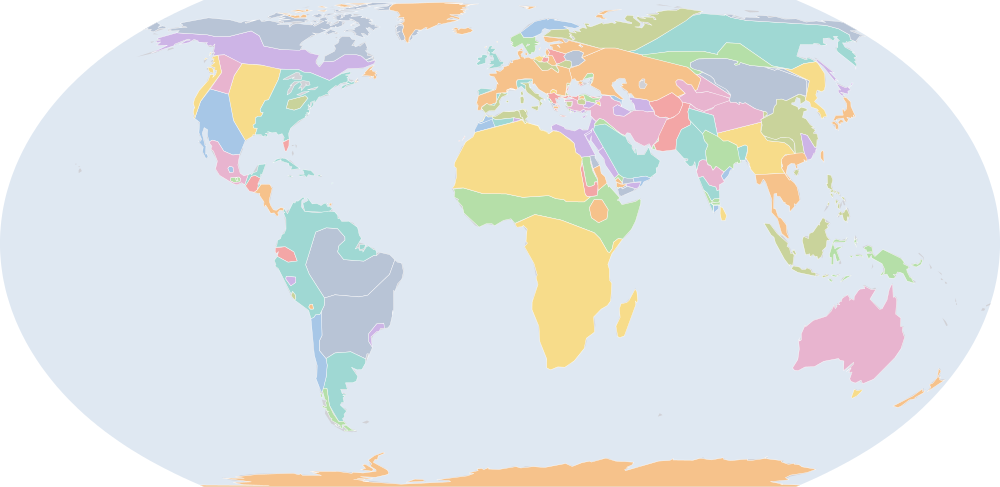
この年にページがある理由
historical-basemaps の地図帳がこの年の世界図を描いています。
地図に描かれる名前
地図が書く名前で、描かれる輪郭の面積が大きい順に並べています。面積は描かれた輪郭のもので、丸めた概算です。「記録」はその輪郭を描く記録で、記録が Wikidata の項目を結んでいる場合はそれを示します。
| 名前 | 出典の綴り | 記録 | 描かれる面積(km²) |
|---|---|---|---|
| Khoiasan | historical-basemaps | 11,700,000 | |
| Saharan Pastoral Nomads | historical-basemaps | 9,500,000 | |
| オーストラリア先住民の狩猟採集民 (出典による説明で、名前ではない) | Australian aboriginal hunter-gatherers | historical-basemaps | 7,600,000 |
| 古シベリア系の狩猟採集民 (出典による説明で、名前ではない) | Paleo-Siberian hunter-gatherers | historical-basemaps | 7,170,000 |
| 西アフリカの穀作農耕民 (出典による説明で、名前ではない) | West African cereal farmers | historical-basemaps | 6,000,000 |
| 北極圏の海獣狩猟民 (出典による説明で、名前ではない) | Arctic marine mammal hunters | historical-basemaps | 5,910,000 |
| キャッサバ農耕民 (出典による説明で、名前ではない) | Manioc farmers | historical-basemaps | 4,840,000 |
| サバンナの狩猟採集民 (出典による説明で、名前ではない) | Savanna hunter-gatherers | historical-basemaps | 4,820,000 |
| Scythians | historical-basemaps | 4,810,000 | |
| 匈奴 | Xiongnu | Cliopatria · historical-basemaps Q188836 | 4,340,000 |
| 亜寒帯林の狩猟採集民 (出典による説明で、名前ではない) | Subarctic forest hunter-gatherers | historical-basemaps | 4,330,000 |
| アマゾンの狩猟採集民 (出典による説明で、名前ではない) | Amazon hunter-gatherers | historical-basemaps | 4,280,000 |
| フィン・ウゴル系タイガの狩猟採集民 (出典による説明で、名前ではない) | Finno-Ugric taiga hunter-gatherers | historical-basemaps | 3,510,000 |
| 北米東部の狩猟採集民 (出典による説明で、名前ではない) | Eastern North Amercian hunter-gatherers | historical-basemaps | 3,340,000 |
| 平原のバイソン狩猟民 (出典による説明で、名前ではない) | Plain bison hunters | historical-basemaps | 2,820,000 |
| 月氏 | Yuezhi | Cliopatria · historical-basemaps Q467985 | 2,660,000 |
| 砂漠の狩猟採集民 (出典による説明で、名前ではない) | Desert hunter-gatherers | historical-basemaps | 2,350,000 |
| セレウコス王家 | Seleucid Empire | Cliopatria Q705904 | 2,280,000 |
| Thai | historical-basemaps | 2,240,000 | |
| Arabs | historical-basemaps | 2,090,000 | |
| 漢 | Han Dynasty | Cliopatria Q7209 | 2,050,000 |
| パンパの諸文化 (出典による説明で、名前ではない) | Pampas cultures | historical-basemaps | 1,830,000 |
| テュルク系の諸部族 (出典による説明で、名前ではない) | Turcik tribes | historical-basemaps | 1,610,000 |
| マレー人 | Malays | historical-basemaps | 1,510,000 |
| マウリヤ朝 | Mauryan Empire | historical-basemaps | 1,500,000 |
| Mon-Khmer | historical-basemaps | 1,210,000 | |
| マウリヤ朝 | Maurya Empire | Cliopatria Q62943 | 1,140,000 |
| パプア諸語 | Papuan | historical-basemaps | 1,050,000 |
| Tungus | historical-basemaps | 992,000 | |
| Bactria | historical-basemaps | 991,000 | |
| トウモロコシ農耕民 (出典による説明で、名前ではない) | Maize farmers | historical-basemaps | 823,000 |
| プトレマイオス王国 | Ptolemaic Kingdom | Cliopatria · historical-basemaps Q2320005 | 800,000 |
| アンデスの狩猟採集民 (出典による説明で、名前ではない) | Andean hunter-gatherers | historical-basemaps | 744,000 |
| 高原の漁労民・狩猟採集民 (出典による説明で、名前ではない) | Plateau fichers and hunter gatherers | historical-basemaps | 722,000 |
| グレコ・バクトリア王国 | Greco-Bactrian Kingdom | Cliopatria Q488880 | 685,000 |
| Saami | historical-basemaps | 631,000 | |
| 共和政ローマ | Roman Republic | Cliopatria Q17167 | 595,000 |
| シャンシュン王国 | Zhangzhung Kingdom | historical-basemaps | 561,000 |
| サータヴァーハナ朝 | Satavahana Dynasty | Cliopatria Q5257 | 537,000 |
| North American Pacifi foraging, hunting and fishing peoples | historical-basemaps | 533,000 | |
| カリブ海域の狩猟採集民 (出典による説明で、名前ではない) | Caribbean hunter-gatherers | historical-basemaps | 513,000 |
| Norsemen | historical-basemaps | 369,000 | |
| Celts | historical-basemaps | 361,000 | |
| 南越国 | Nanyue | Cliopatria Q827040 | 353,000 |
| クシュ | Kingdom of Kush | Cliopatria Q241790 | 337,000 |
| Meroe | historical-basemaps | 278,000 | |
| 閩越 | Minyue | Cliopatria Q1936158 | 269,000 |
| Chorrera | historical-basemaps | 262,000 | |
| パタゴニアの貝類・海獣狩猟民 (出典による説明で、名前ではない) | Patagonian shellfish and marine mammal hunters | historical-basemaps | 259,000 |
| 無文土器文化 (出典による説明で、名前ではない) | Plain-Pottery culture | historical-basemaps | 258,000 |
全118の名前
| 名前 | 出典の綴り | 記録 | 描かれる面積(km²) |
|---|---|---|---|
| パルティア王国 | Parthian Empire | Cliopatria Q1986139 | 254,000 |
| アデナ文化 | Adena Culture | historical-basemaps | 225,000 |
| Maan | historical-basemaps | 219,000 | |
| マウレタニア | Mauretania | Cliopatria · historical-basemaps Q309272 | 217,000 |
| マヤ文明 | Mayan City-States | Cliopatria Q28567 | 199,000 |
| 漢 | Han Empire | historical-basemaps | 193,000 |
| Qataban | Cliopatria · historical-basemaps Q748595 | 189,000 | |
| 刷毛目土器文化 (出典による説明で、名前ではない) | Brushed Pottery culture | historical-basemaps | 184,000 |
| ナバテア王国 | Nabatean Kingdom | historical-basemaps | 177,000 |
| ローマ | Rome | historical-basemaps | 164,000 |
| 鐘形墓文化 (出典による説明で、名前ではない) | Bell-shaped burials culture | historical-basemaps | 159,000 |
| Ainu | historical-basemaps | 159,000 | |
| マヤの首長国と諸国家 (出典による説明で、名前ではない) | Maya chiefdoms and states | historical-basemaps | 153,000 |
| 古代カルタゴ | Carthage | Cliopatria · historical-basemaps Q2429397 | 150,000 |
| 貝類採集民 (出典による説明で、名前ではない) | Shellfish gatherers | historical-basemaps | 149,000 |
| アトロパテネ王国 | Atropatene | Cliopatria Q260437 | 147,000 |
| Kingdom of Syphax | historical-basemaps | 147,000 | |
| セレウコス朝 | Seleucid Kingdom | historical-basemaps | 137,000 |
| アンティゴノス朝 | Antigonid Macedonia | Cliopatria Q237325 | 114,000 |
| Hadramaut | historical-basemaps | 98,100 | |
| ミログラード文化 | Milograd culture | historical-basemaps | 97,800 |
| ポントス王国 | Kingdom of Pontus | Cliopatria Q7380487 | 93,100 |
| Blemmyes | historical-basemaps | 88,900 | |
| ハドラマウト | Hadhramaut | Cliopatria Q1517159 | 86,500 |
| Chavin | historical-basemaps | 82,900 | |
| Kalinga | Cliopatria | 81,700 | |
| Greek City-States | Cliopatria | 78,500 | |
| 東マズーリ文化 (出典による説明で、名前ではない) | Eastern Masurian culture | historical-basemaps | 74,500 |
| アヌラダープラ | Anurādhapura | Cliopatria Q5724 | 74,200 |
| Iron Age chieftainships | historical-basemaps | 71,200 | |
| カッパドキア王国 | Kingdom of Cappadocia | Cliopatria Q29654286 | 67,600 |
| 小国家群 (出典による説明で、名前ではない) | minor states | historical-basemaps | 66,000 |
| タスマニアの狩猟採集民 (出典による説明で、名前ではない) | Tasmanian hunter-gatherers | historical-basemaps | 59,400 |
| Glades Culture | historical-basemaps | 59,100 | |
| モンテ=アルバン | Monte Albán | historical-basemaps | 57,100 |
| ボスポロス王国 | Bosporan Kingdom | historical-basemaps | 52,900 |
| ガラティア | Galatia | Cliopatria Q26847 | 50,700 |
| ポメラニア文化 | Pomeranian culture | historical-basemaps | 44,400 |
| シバ王国 | Saba | historical-basemaps | 41,900 |
| Teotihuacán | historical-basemaps | 40,700 | |
| ペルガモン王国 | Kingdom of Pergamon | Cliopatria Q2022162 | 38,400 |
| サバア王国 | Sabaeans | Cliopatria Q940785 | 35,800 |
| Macedon and Hellenic League | historical-basemaps | 35,100 | |
| Nan-Yue | historical-basemaps | 34,300 | |
| Early Pandyas | Cliopatria | 32,700 | |
| 西マズーリ文化 (出典による説明で、名前ではない) | Western Masurian culture | historical-basemaps | 32,600 |
| Kingdom of Bithynia | Cliopatria Q3762571 | 29,900 | |
| Paracas | historical-basemaps | 29,500 | |
| Early Cholas | Cliopatria Q3532146 | 29,000 | |
| Kingdom of Gala | historical-basemaps | 28,600 | |
| Minaeans | Cliopatria | 28,600 | |
| Early Cheras | Cliopatria | 25,500 | |
| ? | historical-basemaps | 25,400 | |
| ボスポロス王国 | Cimmerian Bosporus | Cliopatria Q321371 | 25,000 |
| Arakan | historical-basemaps | 23,700 | |
| パフラゴニア | Paphlagonia | Cliopatria Q622032 | 22,900 |
| Dardania | historical-basemaps | 21,900 | |
| クロニア人 | Curonians | historical-basemaps | 21,700 |
| Wankarani | historical-basemaps | 19,700 | |
| ソフェーネ王国 | Kingdom of Sophene | Cliopatria Q2626105 | 17,000 |
| アカイア同盟 | Achaean League | Cliopatria Q244796 | 11,800 |
| アエトリア同盟 | Aetolian League | Cliopatria Q245273 | 10,300 |
| グアンチェ族 | Guanches | historical-basemaps | 9,080 |
| ザンビア・ノータンゲン文化 (出典による説明で、名前ではない) | Sambian-Nothangian culture | historical-basemaps | 8,310 |
| Zapotec Civilization | Cliopatria | 6,470 | |
| Parthia | historical-basemaps | 1,610 | |
| Pergamon | historical-basemaps | 1,090 | |
| Min-Yue | historical-basemaps | 485 |
紀元前300年からの変化
数えるのは、年または日の単位で日付を持つ記録(CShapes・OpenHistoricalMap・Cliopatria)の名前です。最も近い historical-basemaps の図から補った輪郭は、両方の年がその図の描かれた年であるときだけ数えます——そうでなければ、変化は2枚の図の切り替わりであって世界の変化ではないからです。名前は書かれたとおりに比べるので、記録が2つの年で別の名前で書く政体(Carthaginian Empire と Carthage など)は両方の欄に出ます。
新たに描かれる(48)
Scythians、匈奴、Thai、Arabs、漢、テュルク系の諸部族、マレー人、Mon-Khmer、パプア諸語、Tungus、Bactria、トウモロコシ農耕民、グレコ・バクトリア王国、サータヴァーハナ朝、Norsemen、南越国、パルティア王国、Maan、マウレタニア、マヤ文明、漢、ローマ、Kingdom of Syphax、アンティゴノス朝、ポントス王国、アヌラダープラ、Iron Age chieftainships、カッパドキア王国、小国家群、タスマニアの狩猟採集民、ガラティア、ペルガモン王国、Macedon and Hellenic League、Nan-Yue、Early Pandyas、Early Cholas、Kingdom of Gala、Early Cheras、?、Arakan、パフラゴニア、Dardania、ソフェーネ王国、アカイア同盟、アエトリア同盟、Parthia、Pergamon、Min-Yue
描かれなくなった(33)
Warring States China、秦、ヒンドゥー諸王国と共和国、周の諸国、楚、古代カルタゴ、Kingdom of Lysimachus、Scythia、マケドニア王国、アルメニア王国、ヒンドゥー諸王国、斉、Damot、魏、カッパドキア、Kingdom of Antigonus、Simhala、趙、コルキス、燕、ギリシアの都市国家、宋、エトルリア人、キレナイカ、Han、中山市、魯、衛、アルメニア、Kingdom of Kassander、クレタ島、Bithynia、越
紀元前200年の出来事
日付つき出来事の索引には、紀元前200年の出来事がありません。
出典と方法
国境と名前:Cliopatria v0.2.1 (Seshat Global History Databank, github.com/Seshat-Global-History-Databank/cliopatria) · CC BY 4.0 · adapted by IntMap: simplified, BC years made astronomical, and the ground OpenHistoricalMap (1689–1885, and from 1886 where CShapes is silent) and CShapes (1886–2019) state removed on their own dates + aourednik/historical-basemaps (github.com/aourednik/historical-basemaps) · GPL-3.0 · adapted by IntMap: each sheet before 1886 less the ground OpenHistoricalMap and Cliopatria state at that sheet's year。
どの年にページがあるかは、サイトのビルド時に記録そのものに3つの規則を当てて決めています:historical-basemaps の地図帳が世界図を描いたすべての年/前年からの変化(日付を持つ記録が描き始める・描かなくなる名前の数)が、日付を持つ記録が始まって以来の年ごとの変化の上位5%に入るすべての年(ある記録から別の記録へ引き継ぐ年は除く)/日付つき出来事の索引にある地政・戦争・革命の出来事のすべての年(国境の記録が覆う最後の年 2019 年まで)。
各年は7月1日で地図を読みます(アプリの年のリンクが開く瞬間)。名前は出典のもので、出典か IntMap の名前表に訳があるときは訳します。名前は記録が描くものであって、何が存在したかの判定ではありません。