The world in 1946
On 1 July 1946, IntMap’s historical map draws 174 names across the world. The borders for this date come from CShapes 2.0 (day by day), then Cliopatria, Seshat Global History Databank (by year) — each drawn only where the records before it are silent. It also draws 2 outlines whose name the record does not give for this date.
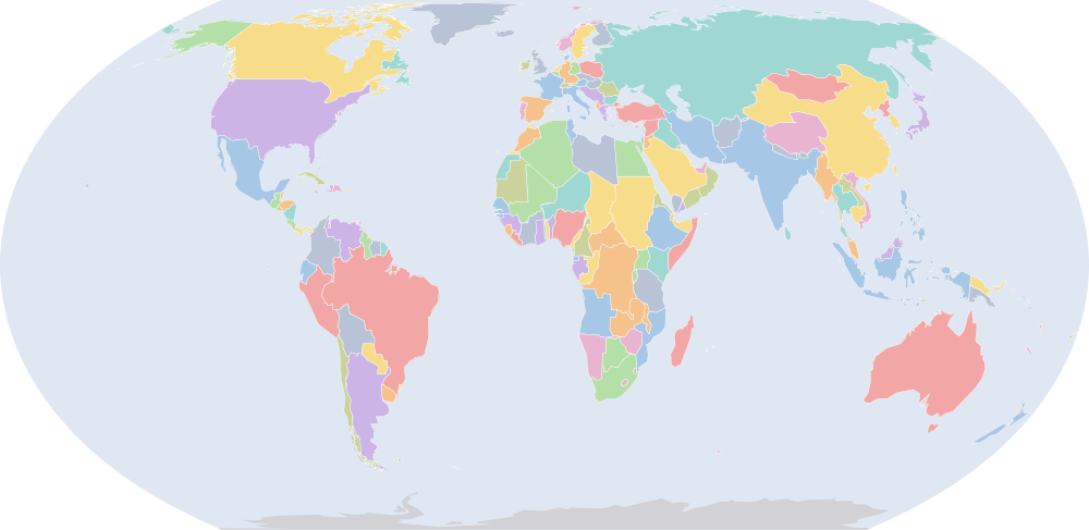
Why this year has a page
Among the largest year-to-year changes in the records the map dates by year or by day: 23 names begin or stop being drawn between 1 July 1945 and 1 July 1946.
Names on the map
As the map labels them, largest first by the area of the outline drawn. Areas are of the drawn outline, rounded, and approximate. The record column says which record draws the outline; a Wikidata item is given where the record links one.
| Name | Record | Drawn area (km²) |
|---|---|---|
| Soviet Union | CShapes 2.0 · Cliopatria Q15180 | 22,000,000 |
| Canada | CShapes 2.0 | 9,530,000 |
| Brazil | CShapes 2.0 | 8,510,000 |
| United States | CShapes 2.0 | 7,940,000 |
| Australia | CShapes 2.0 | 7,710,000 |
| Republic of China | CShapes 2.0 | 7,540,000 |
| British Raj (British India) | CShapes 2.0 | 4,240,000 |
| Argentina | CShapes 2.0 | 2,780,000 |
| Anglo-Egyptian Sudan | CShapes 2.0 | 2,500,000 |
| Belgian Congo (Belgium) | CShapes 2.0 | 2,340,000 |
| Algeria (France) | CShapes 2.0 | 2,320,000 |
| Denmark | CShapes 2.0 · Cliopatria Q35 | 2,260,000 |
| Mexico | CShapes 2.0 | 1,970,000 |
| Saudi Arabia | CShapes 2.0 | 1,960,000 |
| Dutch East Indies | CShapes 2.0 | 1,900,000 |
| Tibet | CShapes 2.0 | 1,810,000 |
| Imperial State of Iran | CShapes 2.0 | 1,620,000 |
| Libya (UK) | CShapes 2.0 | 1,620,000 |
| Mongolia | CShapes 2.0 | 1,560,000 |
| Alaska (USA) | CShapes 2.0 | 1,500,000 |
| French Sudan (France) | CShapes 2.0 | 1,310,000 |
| Peru | CShapes 2.0 | 1,300,000 |
| Chad (France) | CShapes 2.0 | 1,280,000 |
| Niger (France) | CShapes 2.0 | 1,260,000 |
| Angola (Portugal) | CShapes 2.0 | 1,250,000 |
| Union of South Africa | CShapes 2.0 | 1,220,000 |
| Colombia | CShapes 2.0 | 1,140,000 |
| Ethiopian Empire | CShapes 2.0 | 1,130,000 |
| Bolivia | CShapes 2.0 | 1,090,000 |
| Mauritania (France) | CShapes 2.0 | 1,040,000 |
| Kingdom of Egypt | CShapes 2.0 | 1,000,000 |
| Tanganyika (UK) | CShapes 2.0 | 943,000 |
| Venezuela | CShapes 2.0 · Cliopatria Q717 | 929,000 |
| Nigeria (UK) | CShapes 2.0 | 867,000 |
| South West Africa (South Africa) | CShapes 2.0 | 827,000 |
| Mozambique (Portugal) | CShapes 2.0 | 790,000 |
| Turkey | CShapes 2.0 | 781,000 |
| Northern Rhodesia (UK) | CShapes 2.0 | 755,000 |
| Chile | CShapes 2.0 | 749,000 |
| Burma (UK) | CShapes 2.0 | 670,000 |
| Afghanistan | CShapes 2.0 | 642,000 |
| Ubangi-Shari (France) | CShapes 2.0 | 621,000 |
| Madagascar (France) | CShapes 2.0 | 598,000 |
| Kenya (UK) | CShapes 2.0 | 585,000 |
| Bechuanaland (UK) | CShapes 2.0 | 580,000 |
| France | CShapes 2.0 | 548,000 |
| Thailand | CShapes 2.0 | 515,000 |
| Francoist Spain | CShapes 2.0 | 507,000 |
| Cote d'Ivoire (France) | CShapes 2.0 | 470,000 |
| Italian Somaliland | CShapes 2.0 | 467,000 |
All 174 names
| Name | Record | Drawn area (km²) |
|---|---|---|
| Sweden | CShapes 2.0 | 444,000 |
| Iraq | CShapes 2.0 | 436,000 |
| French Cameroons (France) | CShapes 2.0 | 425,000 |
| Newfoundland | CShapes 2.0 | 400,000 |
| Paraguay | CShapes 2.0 | 400,000 |
| Southern Rhodesia (UK) | CShapes 2.0 | 391,000 |
| Empire of Japan | CShapes 2.0 | 372,000 |
| Morocco (France) | CShapes 2.0 | 351,000 |
| French Congo (France) | CShapes 2.0 | 346,000 |
| Finland | CShapes 2.0 | 334,000 |
| Vietnam (France) | CShapes 2.0 | 327,000 |
| Norway | CShapes 2.0 | 322,000 |
| Poland | CShapes 2.0 | 311,000 |
| Muscat and Oman | CShapes 2.0 | 310,000 |
| Italy | CShapes 2.0 | 301,000 |
| Philippines (USA) | CShapes 2.0 | 299,000 |
| New Zealand | CShapes 2.0 | 271,000 |
| Spanish West Africa | CShapes 2.0 | 270,000 |
| Gabon (France) | CShapes 2.0 | 263,000 |
| Ecuador | CShapes 2.0 | 257,000 |
| Yugoslavia (SFRY) | CShapes 2.0 | 255,000 |
| Germany (Western Allies) | CShapes 2.0 | 248,000 |
| French Guinea (France) | CShapes 2.0 | 246,000 |
| United Kingdom | CShapes 2.0 | 246,000 |
| Uganda (UK) | CShapes 2.0 | 243,000 |
| East Aden Protectorate | CShapes 2.0 | 242,000 |
| New Guinea (Australia) | CShapes 2.0 | 240,000 |
| Romania | CShapes 2.0 | 237,000 |
| Laos (France) | CShapes 2.0 | 231,000 |
| Papua (Australia) | CShapes 2.0 | 226,000 |
| Gold Coast (UK) | CShapes 2.0 | 213,000 |
| British Guiana (UK) | CShapes 2.0 | 212,000 |
| Senegal (France) | CShapes 2.0 | 197,000 |
| Syria | CShapes 2.0 | 188,000 |
| Cambodia (France) | CShapes 2.0 | 183,000 |
| Uruguay | CShapes 2.0 | 178,000 |
| British Somaliland (UK) | CShapes 2.0 | 173,000 |
| Tunisia (France) | CShapes 2.0 | 156,000 |
| Nepal | CShapes 2.0 | 147,000 |
| Dutch Guiana (Netherlands) | CShapes 2.0 | 146,000 |
| Yemen | CShapes 2.0 | 137,000 |
| Malaya (UK) | CShapes 2.0 | 133,000 |
| Greece | CShapes 2.0 | 132,000 |
| Nicaragua | CShapes 2.0 | 129,000 |
| Sarawak (UK) | CShapes 2.0 | 125,000 |
| Korea (USSR) | CShapes 2.0 | 123,000 |
| Eritrea (UK) | CShapes 2.0 | 122,000 |
| Nyasaland (UK) | CShapes 2.0 | 119,000 |
| Dahomey (France) | CShapes 2.0 | 117,000 |
| Honduras | CShapes 2.0 | 113,000 |
| Czechoslovakia | CShapes 2.0 | 112,000 |
| Bulgaria | CShapes 2.0 | 111,000 |
| Cuba | CShapes 2.0 | 111,000 |
| Guatemala | CShapes 2.0 | 109,000 |
| Germany (USSR) | CShapes 2.0 | 109,000 |
| Hungary | CShapes 2.0 | 108,000 |
| Iceland | CShapes 2.0 | 103,000 |
| Korea (USA) | CShapes 2.0 | 98,300 |
| Liberia | CShapes 2.0 | 96,500 |
| Portugal | CShapes 2.0 | 92,300 |
| Transjordan | CShapes 2.0 | 89,300 |
| British Cameroons | CShapes 2.0 | 87,900 |
| French Guiana (France) | CShapes 2.0 | 84,200 |
| Austria | CShapes 2.0 | 83,700 |
| Panama | CShapes 2.0 | 75,500 |
| Kingdom of Norway | Cliopatria Q20 | 74,200 |
| North Borneo (UK) | CShapes 2.0 | 73,300 |
| Sierra Leone (UK) | CShapes 2.0 | 72,900 |
| Trucial Oman (UK) | CShapes 2.0 | 70,900 |
| Ireland | CShapes 2.0 | 70,000 |
| Ceylon (UK) | CShapes 2.0 | 66,800 |
| French Togoland (France) | CShapes 2.0 | 57,300 |
| Spanish Morocco | CShapes 2.0 | 53,300 |
| Ruanda-Urundi (Belgium) | CShapes 2.0 | 52,600 |
| Costa Rica | CShapes 2.0 | 51,600 |
| Dominican Republic | CShapes 2.0 | 48,700 |
| Aden (UK) | CShapes 2.0 | 46,700 |
| Switzerland | CShapes 2.0 | 41,400 |
| British Colonial Empire | Cliopatria Q8680 | 40,900 |
| Bhutan | CShapes 2.0 | 39,900 |
| British Empire | Cliopatria Q8680 | 37,300 |
| Netherlands | CShapes 2.0 | 35,000 |
| Portuguese Guinea (Portugal) | CShapes 2.0 | 33,600 |
| Basutoland (UK) | CShapes 2.0 | 30,600 |
| Belgium | CShapes 2.0 | 30,500 |
| Albania | CShapes 2.0 | 28,700 |
| British Solomon Islands (UK) | CShapes 2.0 | 27,800 |
| Haiti | CShapes 2.0 | 27,500 |
| Spanish Guinea (Spain) | CShapes 2.0 | 27,200 |
| Mandatory Palestine | CShapes 2.0 | 27,000 |
| British Togoland | CShapes 2.0 | 26,700 |
| New Caledonia (France) | CShapes 2.0 | 24,000 |
| British Honduras (UK) | CShapes 2.0 | 22,300 |
| French Somaliland (France) | CShapes 2.0 | 21,600 |
| El Salvador | CShapes 2.0 | 20,700 |
| Fiji (UK) | CShapes 2.0 | 18,500 |
| New Hebrides | Cliopatria Q752431 | 17,400 |
| Hawaii (USA) | CShapes 2.0 | 17,300 |
| Swaziland (UK) | CShapes 2.0 | 17,100 |
| Portuguese Timor (Portugal) | CShapes 2.0 | 15,300 |
| French Polynesia (France) | CShapes 2.0 | 13,000 |
| Bahamas (UK) | CShapes 2.0 | 12,800 |
| French Fourth Republic | Cliopatria Q69829 | 12,600 |
| Jamaica (UK) | CShapes 2.0 | 11,200 |
| Qatar (UK) | CShapes 2.0 | 11,200 |
| Gambia (UK) | CShapes 2.0 | 10,900 |
| Brazilian Republic | Cliopatria Q155 | 10,700 |
| Lebanon | CShapes 2.0 | 10,300 |
| Puerto Rico (USA) | CShapes 2.0 | 9,310 |
| Cyprus | CShapes 2.0 | 9,300 |
| Brunei (UK) | CShapes 2.0 | 5,770 |
| Trinidad and Tobago (UK) | CShapes 2.0 | 5,240 |
| Cape Verde | CShapes 2.0 | 4,040 |
| Ryukyu Islands (USA) | CShapes 2.0 | 3,170 |
| Sultanate of Zanzibar | CShapes 2.0 | 2,690 |
| Reunion (France) | CShapes 2.0 | 2,660 |
| Luxembourg | CShapes 2.0 | 2,570 |
| Mauritius (UK) | CShapes 2.0 | 2,160 |
| Guadeloupe (France) | CShapes 2.0 | 1,700 |
| Martinique (France) | CShapes 2.0 | 1,200 |
| Singapore (UK) | CShapes 2.0 | 565 |
| Barbados (UK) | CShapes 2.0 | 457 |
| Malta | CShapes 2.0 | 292 |
| Maldives (UK) | CShapes 2.0 | 27.8 |
What changed since 1945
Names counted are those the records date to the year or the day (CShapes, OpenHistoricalMap, Cliopatria). Outlines filled from the nearest historical-basemaps sheet are counted only when both years are years that sheet was drawn for — otherwise the change would be the switch between two sheets, not a change in the world. Names are compared as written, so a polity a record names differently in the two years (Carthaginian Empire, then Carthage) is in both lists.
Now drawn (13)
Italy, Yugoslavia (SFRY), Syria, Malaya (UK), Sarawak (UK), Korea (USSR), Hungary, Korea (USA), Transjordan, French Fourth Republic, Brazilian Republic, Ryukyu Islands (USA), Singapore (UK)
No longer drawn (15)
Kingdom of Italy, Kingdom of Yugoslavia, Korea (Japan), Syria (France), Sarawak, Kingdom of Hungary, Transjordan (UK), Federated Malay States, Inini, Unfederated Malay States, Taiwan (Japan), Karafuto (Japan), British Africa, Unitary State of Brazil, Straits Settlements
Events dated to 1946
Every record of IntMap’s one index of dated events whose date falls in this year: what the border record (CShapes 2.0) states about its own outlines, IntMap’s war record, and the world events Wikidata dates — each with its source and the precision of its date.
- 1946
The map begins drawing Syria; the map stops drawing Syria (France)
the border record (CShapes 2.0) · 1946-01-01
On this day → - 1946
The map begins drawing Ryukyu Islands (USA); new borders for Empire of Japan
the border record (CShapes 2.0) · 1946-01-29
On this day → - 1946
The map stops drawing Inini; new borders for French Guiana (France)
the border record (CShapes 2.0) · 1946-03-19
On this day → - 1946
The map begins drawing Malaya (UK), Singapore (UK); the map stops drawing Federated Malay States, Unfederated Malay States, Straits Settlements
the border record (CShapes 2.0) · 1946-04-01
On this day → - 1946
The map begins drawing Transjordan; the map stops drawing Transjordan (UK)
the border record (CShapes 2.0) · 1946-05-25
On this day → - 1946
The map begins drawing Sarawak (UK); the map stops drawing Sarawak
the border record (CShapes 2.0) · 1946-07-01
On this day → - 1946
The map begins drawing Philippines; the map stops drawing Philippines (USA)
the border record (CShapes 2.0) · 1946-07-04
On this day → - 1946
The map begins drawing Comoros (France); new borders for Madagascar (France)
the border record (CShapes 2.0) · 1946-10-27
On this day →
Sources and method
Borders and names: CShapes 2.0 (Schvitz et al. 2022, icr.ethz.ch/data/cshapes) · CC BY-NC-SA 4.0 + Cliopatria v0.2.1 (Seshat Global History Databank, github.com/Seshat-Global-History-Databank/cliopatria) · CC BY 4.0 · adapted by IntMap: simplified, BC years made astronomical, and the ground OpenHistoricalMap (1689–1885, and from 1886 where CShapes is silent) and CShapes (1886–2019) state removed on their own dates.
Which years have a page is worked out when the site is built, from three rules applied to the records themselves: every year the historical-basemaps atlas drew a world sheet for; every year whose change from the year before (names the dated records begin or stop drawing) is in the top 5% of all such year-to-year changes since the dated records begin, leaving out the years where one record hands over to another; and every year of a geopolitical, war or revolution event in the dated events index, up to the last year the border records cover (2019).
On each year the map is read on 1 July, the instant the app’s own year links open on. Names are the source’s own, translated where the source or IntMap’s name table has a translation. A name is what a record draws there, not a verdict of history.
World map in 1946 — the map, with the years it stays the same Historical maps by region Countries On this day