The world in 1945
On 1 July 1945, IntMap’s historical map draws 176 names across the world. The borders for this date come from CShapes 2.0 (day by day), then Cliopatria, Seshat Global History Databank (by year) — each drawn only where the records before it are silent. It also draws 3 outlines whose name the record does not give for this date.
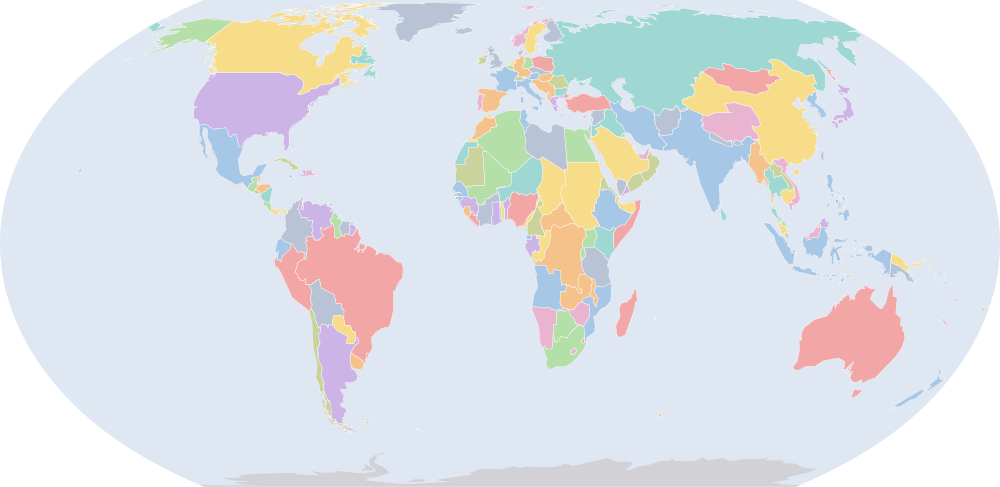
Why this year has a page
The historical-basemaps atlas drew a world sheet for this year.
The year of United Nations (dated events index, Wikidata).
Names on the map
As the map labels them, largest first by the area of the outline drawn. Areas are of the drawn outline, rounded, and approximate. The record column says which record draws the outline; a Wikidata item is given where the record links one.
| Name | Record | Drawn area (km²) |
|---|---|---|
| Soviet Union | CShapes 2.0 · Cliopatria Q15180 | 22,000,000 |
| Canada | CShapes 2.0 | 9,530,000 |
| Brazil | CShapes 2.0 | 8,510,000 |
| United States | CShapes 2.0 | 7,940,000 |
| Australia | CShapes 2.0 | 7,710,000 |
| Republic of China | CShapes 2.0 | 7,500,000 |
| British Raj (British India) | CShapes 2.0 | 4,240,000 |
| Argentina | CShapes 2.0 | 2,780,000 |
| Anglo-Egyptian Sudan | CShapes 2.0 | 2,500,000 |
| Belgian Congo (Belgium) | CShapes 2.0 | 2,340,000 |
| Algeria (France) | CShapes 2.0 | 2,320,000 |
| Denmark | CShapes 2.0 · Cliopatria Q35 | 2,260,000 |
| Mexico | CShapes 2.0 | 1,970,000 |
| Saudi Arabia | CShapes 2.0 | 1,960,000 |
| Dutch East Indies | CShapes 2.0 | 1,900,000 |
| Tibet | CShapes 2.0 | 1,810,000 |
| Imperial State of Iran | CShapes 2.0 | 1,620,000 |
| Libya (UK) | CShapes 2.0 | 1,620,000 |
| Mongolia | CShapes 2.0 | 1,560,000 |
| Alaska (USA) | CShapes 2.0 | 1,500,000 |
| French Sudan (France) | CShapes 2.0 | 1,310,000 |
| Peru | CShapes 2.0 | 1,300,000 |
| Chad (France) | CShapes 2.0 | 1,280,000 |
| Niger (France) | CShapes 2.0 | 1,260,000 |
| Angola (Portugal) | CShapes 2.0 | 1,250,000 |
| Union of South Africa | CShapes 2.0 | 1,220,000 |
| Colombia | CShapes 2.0 | 1,140,000 |
| Ethiopian Empire | CShapes 2.0 | 1,130,000 |
| Bolivia | CShapes 2.0 | 1,090,000 |
| Mauritania (France) | CShapes 2.0 | 1,040,000 |
| Kingdom of Egypt | CShapes 2.0 | 1,000,000 |
| Tanganyika (UK) | CShapes 2.0 | 943,000 |
| Venezuela | CShapes 2.0 · Cliopatria Q717 | 929,000 |
| Nigeria (UK) | CShapes 2.0 | 867,000 |
| South West Africa (South Africa) | CShapes 2.0 | 827,000 |
| Mozambique (Portugal) | CShapes 2.0 | 790,000 |
| Turkey | CShapes 2.0 | 781,000 |
| Northern Rhodesia (UK) | CShapes 2.0 | 755,000 |
| Chile | CShapes 2.0 | 749,000 |
| Burma (UK) | CShapes 2.0 | 670,000 |
| Afghanistan | CShapes 2.0 | 642,000 |
| Ubangi-Shari (France) | CShapes 2.0 | 621,000 |
| Madagascar (France) | CShapes 2.0 | 598,000 |
| Kenya (UK) | CShapes 2.0 | 585,000 |
| Bechuanaland (UK) | CShapes 2.0 | 580,000 |
| France | CShapes 2.0 | 548,000 |
| Thailand | CShapes 2.0 | 515,000 |
| Francoist Spain | CShapes 2.0 | 507,000 |
| Cote d'Ivoire (France) | CShapes 2.0 | 470,000 |
| Italian Somaliland | CShapes 2.0 | 467,000 |
All 176 names
| Name | Record | Drawn area (km²) |
|---|---|---|
| Sweden | CShapes 2.0 | 444,000 |
| Iraq | CShapes 2.0 | 436,000 |
| French Cameroons (France) | CShapes 2.0 | 425,000 |
| Newfoundland | CShapes 2.0 | 400,000 |
| Paraguay | CShapes 2.0 | 400,000 |
| Southern Rhodesia (UK) | CShapes 2.0 | 391,000 |
| Empire of Japan | CShapes 2.0 · Cliopatria Q188712 | 384,000 |
| Morocco (France) | CShapes 2.0 | 351,000 |
| French Congo (France) | CShapes 2.0 | 346,000 |
| Finland | CShapes 2.0 | 334,000 |
| Vietnam (France) | CShapes 2.0 | 327,000 |
| Norway | CShapes 2.0 | 322,000 |
| Poland | CShapes 2.0 | 311,000 |
| Muscat and Oman | CShapes 2.0 | 310,000 |
| Kingdom of Italy | CShapes 2.0 | 301,000 |
| Philippines (USA) | CShapes 2.0 | 299,000 |
| New Zealand | CShapes 2.0 | 271,000 |
| Spanish West Africa | CShapes 2.0 | 270,000 |
| Gabon (France) | CShapes 2.0 | 263,000 |
| Ecuador | CShapes 2.0 | 257,000 |
| Kingdom of Yugoslavia | CShapes 2.0 | 255,000 |
| Germany (Western Allies) | CShapes 2.0 | 248,000 |
| French Guinea (France) | CShapes 2.0 | 246,000 |
| United Kingdom | CShapes 2.0 | 246,000 |
| Uganda (UK) | CShapes 2.0 | 243,000 |
| East Aden Protectorate | CShapes 2.0 | 242,000 |
| New Guinea (Australia) | CShapes 2.0 | 240,000 |
| Romania | CShapes 2.0 | 237,000 |
| Laos (France) | CShapes 2.0 | 231,000 |
| Papua (Australia) | CShapes 2.0 | 226,000 |
| Korea (Japan) | CShapes 2.0 | 221,000 |
| Gold Coast (UK) | CShapes 2.0 | 213,000 |
| British Guiana (UK) | CShapes 2.0 | 212,000 |
| Senegal (France) | CShapes 2.0 | 197,000 |
| Syria (France) | CShapes 2.0 | 188,000 |
| Cambodia (France) | CShapes 2.0 | 183,000 |
| Uruguay | CShapes 2.0 | 178,000 |
| British Somaliland (UK) | CShapes 2.0 | 173,000 |
| Tunisia (France) | CShapes 2.0 | 156,000 |
| Nepal | CShapes 2.0 | 147,000 |
| Dutch Guiana (Netherlands) | CShapes 2.0 | 146,000 |
| Yemen | CShapes 2.0 | 137,000 |
| Greece | CShapes 2.0 | 132,000 |
| Nicaragua | CShapes 2.0 | 129,000 |
| Sarawak | CShapes 2.0 | 125,000 |
| Eritrea (UK) | CShapes 2.0 | 122,000 |
| Nyasaland (UK) | CShapes 2.0 | 119,000 |
| Dahomey (France) | CShapes 2.0 | 117,000 |
| Honduras | CShapes 2.0 | 113,000 |
| Czechoslovakia | CShapes 2.0 | 112,000 |
| Bulgaria | CShapes 2.0 | 111,000 |
| Cuba | CShapes 2.0 | 111,000 |
| Guatemala | CShapes 2.0 | 109,000 |
| Germany (USSR) | CShapes 2.0 | 109,000 |
| Kingdom of Hungary | CShapes 2.0 | 108,000 |
| Iceland | CShapes 2.0 | 103,000 |
| Liberia | CShapes 2.0 | 96,500 |
| Portugal | CShapes 2.0 | 92,300 |
| Transjordan (UK) | CShapes 2.0 | 89,300 |
| British Cameroons | CShapes 2.0 | 87,900 |
| Austria | CShapes 2.0 | 83,700 |
| Panama | CShapes 2.0 | 75,500 |
| Kingdom of Norway | Cliopatria Q20 | 74,200 |
| North Borneo (UK) | CShapes 2.0 | 73,300 |
| Sierra Leone (UK) | CShapes 2.0 | 72,900 |
| Federated Malay States | CShapes 2.0 | 71,900 |
| Inini | CShapes 2.0 | 71,000 |
| Trucial Oman (UK) | CShapes 2.0 | 70,900 |
| Ireland | CShapes 2.0 | 70,000 |
| Ceylon (UK) | CShapes 2.0 | 66,800 |
| Unfederated Malay States | CShapes 2.0 | 57,600 |
| French Togoland (France) | CShapes 2.0 | 57,300 |
| Spanish Morocco | CShapes 2.0 | 53,300 |
| Ruanda-Urundi (Belgium) | CShapes 2.0 | 52,600 |
| Costa Rica | CShapes 2.0 | 51,600 |
| Dominican Republic | CShapes 2.0 | 48,700 |
| Aden (UK) | CShapes 2.0 | 46,700 |
| Switzerland | CShapes 2.0 | 41,400 |
| Bhutan | CShapes 2.0 | 39,900 |
| British Empire | Cliopatria Q8680 | 37,300 |
| Taiwan (Japan) | CShapes 2.0 | 36,200 |
| Netherlands | CShapes 2.0 | 35,000 |
| Karafuto (Japan) | CShapes 2.0 | 33,800 |
| Portuguese Guinea (Portugal) | CShapes 2.0 | 33,600 |
| Basutoland (UK) | CShapes 2.0 | 30,600 |
| Belgium | CShapes 2.0 | 30,500 |
| Albania | CShapes 2.0 | 28,700 |
| British Solomon Islands (UK) | CShapes 2.0 | 27,800 |
| Haiti | CShapes 2.0 | 27,500 |
| Spanish Guinea (Spain) | CShapes 2.0 | 27,200 |
| Mandatory Palestine | CShapes 2.0 | 27,000 |
| British Togoland | CShapes 2.0 | 26,700 |
| New Caledonia (France) | CShapes 2.0 | 24,000 |
| British Colonial Empire | Cliopatria Q8680 | 22,900 |
| British Honduras (UK) | CShapes 2.0 | 22,300 |
| French Somaliland (France) | CShapes 2.0 | 21,600 |
| El Salvador | CShapes 2.0 | 20,700 |
| Fiji (UK) | CShapes 2.0 | 18,500 |
| New Hebrides | Cliopatria Q752431 | 17,400 |
| Hawaii (USA) | CShapes 2.0 | 17,300 |
| Swaziland (UK) | CShapes 2.0 | 17,100 |
| Portuguese Timor (Portugal) | CShapes 2.0 | 15,300 |
| British Africa | Cliopatria | 15,200 |
| French Guiana (France) | CShapes 2.0 | 13,200 |
| French Polynesia (France) | CShapes 2.0 | 13,000 |
| Bahamas (UK) | CShapes 2.0 | 12,800 |
| Jamaica (UK) | CShapes 2.0 | 11,200 |
| Qatar (UK) | CShapes 2.0 | 11,200 |
| Gambia (UK) | CShapes 2.0 | 10,900 |
| Unitary State of Brazil | Cliopatria Q155 | 10,700 |
| Lebanon | CShapes 2.0 | 10,300 |
| Puerto Rico (USA) | CShapes 2.0 | 9,310 |
| Cyprus | CShapes 2.0 | 9,300 |
| Brunei (UK) | CShapes 2.0 | 5,770 |
| Trinidad and Tobago (UK) | CShapes 2.0 | 5,240 |
| Cape Verde | CShapes 2.0 | 4,040 |
| Straits Settlements | CShapes 2.0 | 3,700 |
| Sultanate of Zanzibar | CShapes 2.0 | 2,690 |
| Reunion (France) | CShapes 2.0 | 2,670 |
| Luxembourg | CShapes 2.0 | 2,570 |
| Mauritius (UK) | CShapes 2.0 | 2,160 |
| Guadeloupe (France) | CShapes 2.0 | 1,700 |
| Martinique (France) | CShapes 2.0 | 1,200 |
| Barbados (UK) | CShapes 2.0 | 457 |
| Malta | CShapes 2.0 | 292 |
| Maldives (UK) | CShapes 2.0 | 27.8 |
What changed since 1938
Names counted are those the records date to the year or the day (CShapes, OpenHistoricalMap, Cliopatria). Outlines filled from the nearest historical-basemaps sheet are counted only when both years are years that sheet was drawn for — otherwise the change would be the switch between two sheets, not a change in the world. Names are compared as written, so a polity a record names differently in the two years (Carthaginian Empire, then Carthage) is in both lists.
Now drawn (10)
Libya (UK), France, Thailand, Francoist Spain, Germany (Western Allies), Eritrea (UK), Germany (USSR), Iceland, British Africa, Lebanon
No longer drawn (13)
Greenland, Libya (Italy), French Third Republic, Siam, Spanish Republic, Nazi Germany, Eritrea (Italy), Iceland (Denmark), Latvia, Lithuania, Estonia, Lebanon (France), Danzig
Events dated to 1945
Every record of IntMap’s one index of dated events whose date falls in this year: what the border record (CShapes 2.0) states about its own outlines, IntMap’s war record, and the world events Wikidata dates — each with its source and the precision of its date.
- 1945
Operation Nordwind — the last German offensive in the west, into Alsace on New Year’s Day
IntMap’s war record — World War II · 1945-01-01 – 1945-01-25
On this day → - 1945
Luzon and Manila — a month of street fighting kills 100,000 civilians
IntMap’s war record — World War II · 1945-01-09 – 1945-03-03
On this day → - 1945
Luzon — the largest campaign of the Pacific war, and it is still being fought on the day Japan surrenders
IntMap’s war record — World War II · 1945-01-09 – 1945-08-15
On this day → - 1945
The Vistula–Oder offensive — 500 km in eighteen days, the fastest advance of the war in Europe
IntMap’s war record — World War II · 1945-01-12 – 1945-02-02
On this day → - 1945
East Prussia — three months to reduce the province, and Königsberg holds until 9 April
IntMap’s war record — World War II · 1945-01-13 – 1945-04-25
On this day → - 1945
The death marches — the camps in the east are evacuated on foot in winter, and 100,000 to 250,000 prisoners die
IntMap’s war record — World War II · 1945-01-18 – 1945-05-08
On this day → - 1945
The Colmar pocket is cleared and France is whole again for the first time since 1940
IntMap’s war record — World War II · 1945-01-20 – 1945-02-09
On this day → - 1945
- 1945
The Manila massacre — about 100,000 civilians are killed during the month of street fighting
IntMap’s war record — World War II · 1945-02-03 – 1945-03-03
On this day → - 1945
Yalta — occupation zones, the Soviet entry against Japan, and elections in Poland
IntMap’s war record — World War II · 1945-02-04 – 1945-02-11
On this day → - 1945
- 1945
- 1945
Meiktila and Mandalay — the Japanese army in Burma is broken in three weeks
IntMap’s war record — World War II · 1945-02-28 – 1945-03-20
On this day → - 1945
Operation Spring Awakening — the last German offensive of the war, for the Hungarian oil, and it fails in ten days
IntMap’s war record — World War II · 1945-03-06 – 1945-03-16
On this day → - 1945
The Ludendorff bridge at Remagen is found standing, and the Rhine is crossed a fortnight early
IntMap’s war record — World War II · 1945-03-07
On this day → - 1945
Operation Meetinghouse — 279 B-29s burn sixteen square miles of Tokyo in one night; about 100,000 die
IntMap’s war record — World War II · 1945-03-09 – 1945-03-10
On this day → - 1945
Operation Varsity — the largest airborne operation ever flown to one place on one day, across the Rhine
IntMap’s war record — World War II · 1945-03-24
On this day → - 1945
The Bratislava-Brno offensive — Slovakia and Moravia in six weeks
IntMap’s war record — World War II · 1945-03-25 – 1945-05-05
On this day → - 1945
- 1945
The Ruhr pocket — 317,000 men, the largest encirclement the Western Allies ever achieved
IntMap’s war record — World War II · 1945-04-01 – 1945-04-18
On this day → - 1945
- 1945
The spring offensive in Italy — the Argenta gap is forced, the Po is crossed, and the German front dissolves in three weeks
IntMap’s war record — World War II · 1945-04-06 – 1945-05-02
On this day → - 1945
The West Hunan offensive — the last Japanese offensive of the war is stopped short of the Zhijiang airfield
IntMap’s war record — World War II · 1945-04-09 – 1945-06-07
On this day → - 1945
- 1945
The Seelow Heights — the last defensive line before Berlin is broken in four days
IntMap’s war record — World War II · 1945-04-16 – 1945-04-19
On this day → - 1945
Elbe Day — American and Soviet patrols meet at Torgau and Germany is cut in two
IntMap’s war record — World War II · 1945-04-25
On this day → - 1945
Fifty nations meet at San Francisco while the fighting in Europe is in its last fortnight
IntMap’s war record — World War II · 1945-04-25 – 1945-06-26
On this day → - 1945
The insurrection of 25 April — Milan, Turin and Genoa are taken by the partisans before the armies arrive
IntMap’s war record — World War II · 1945-04-25
On this day → - 1945
The surrender at Caserta — the German army in Italy lays down its arms six days before the rest
IntMap’s war record — World War II · 1945-05-02
On this day → - 1945
Rangoon is retaken the day before the monsoon breaks
IntMap’s war record — World War II · 1945-05-02
On this day → - 1945
The Prague uprising — the last fighting in Europe, two days after the German surrender was signed
IntMap’s war record — World War II · 1945-05-05 – 1945-05-08
On this day → - 1945
The Prague offensive — the last operation in Europe, and 860,000 men surrender at the end of it
IntMap’s war record — World War II · 1945-05-06 – 1945-05-11
On this day → - 1945
The unconditional surrender is signed at Reims at 02:41, to take effect on the eighth
IntMap’s war record — World War II · 1945-05-07
On this day → - 1945
The map begins drawing Germany (Western Allies), Germany (USSR); the map stops drawing Nazi Germany; new borders for Soviet Union, Poland, Czechoslovakia
the border record (CShapes 2.0) · 1945-05-08
On this day → - 1945
- 1945
Zagreb is taken and the Independent State of Croatia ceases to exist
IntMap’s war record — World War II · 1945-05-08
On this day → - 1945
The Charter of the United Nations is signed by fifty governments
IntMap’s war record — World War II · 1945-06-26
On this day → - 1945
Balikpapan — the last major amphibious operation of the war, for oil nobody would need
IntMap’s war record — World War II · 1945-07-01 – 1945-07-21
On this day → - 1945
- 1945
Potsdam — the last conference of the war, and the ultimatum to Japan
IntMap’s war record — World War II · 1945-07-17 – 1945-08-02
On this day → - 1945
- 1945
The Soviet Union declares war on Japan; the invasion of Manchuria begins an hour after midnight
IntMap’s war record — World War II · 1945-08-08
On this day → - 1945
- 1945
Soviet invasion of Manchuria
IntMap’s war record — World War II · 1945-08-09 – 1945-09-02
On this day → - 1945
The map begins drawing Korea (USSR), Korea (USA); the map stops drawing Korea (Japan), Taiwan (Japan), Karafuto (Japan); new borders for Soviet Union, Republic of China, Empire of Japan
the border record (CShapes 2.0) · 1945-08-15
On this day → - 1945
Korea is freed after 35 years and divided at the 38th parallel within the month
IntMap’s war record — World War II · 1945-08-15
On this day → - 1945
The Emperor’s broadcast: most of his subjects hear his voice for the first time, to be told the war is over
IntMap’s war record — World War II · 1945-08-15
On this day → - 1945
Mukden, Harbin and Changchun are taken; the Kwantung Army has ceased to exist in eleven days
IntMap’s war record — World War II · 1945-08-20
On this day → - 1945
- 1945
The indictment is filed at Nuremberg: for the first time, a court is to try the making of a war
IntMap’s war record — World War II · 1945-10-18
On this day → - 1945
United Nations
global international and intergovernmental organization
founded 1945-10-24 · Wikidata Q1065
Sources and method
Borders and names: CShapes 2.0 (Schvitz et al. 2022, icr.ethz.ch/data/cshapes) · CC BY-NC-SA 4.0 + Cliopatria v0.2.1 (Seshat Global History Databank, github.com/Seshat-Global-History-Databank/cliopatria) · CC BY 4.0 · adapted by IntMap: simplified, BC years made astronomical, and the ground OpenHistoricalMap (1689–1885, and from 1886 where CShapes is silent) and CShapes (1886–2019) state removed on their own dates.
Which years have a page is worked out when the site is built, from three rules applied to the records themselves: every year the historical-basemaps atlas drew a world sheet for; every year whose change from the year before (names the dated records begin or stop drawing) is in the top 5% of all such year-to-year changes since the dated records begin, leaving out the years where one record hands over to another; and every year of a geopolitical, war or revolution event in the dated events index, up to the last year the border records cover (2019).
On each year the map is read on 1 July, the instant the app’s own year links open on. Names are the source’s own, translated where the source or IntMap’s name table has a translation. A name is what a record draws there, not a verdict of history.
World map in 1945 — the map, with the years it stays the same Historical maps by region Countries On this day