The world in 1919
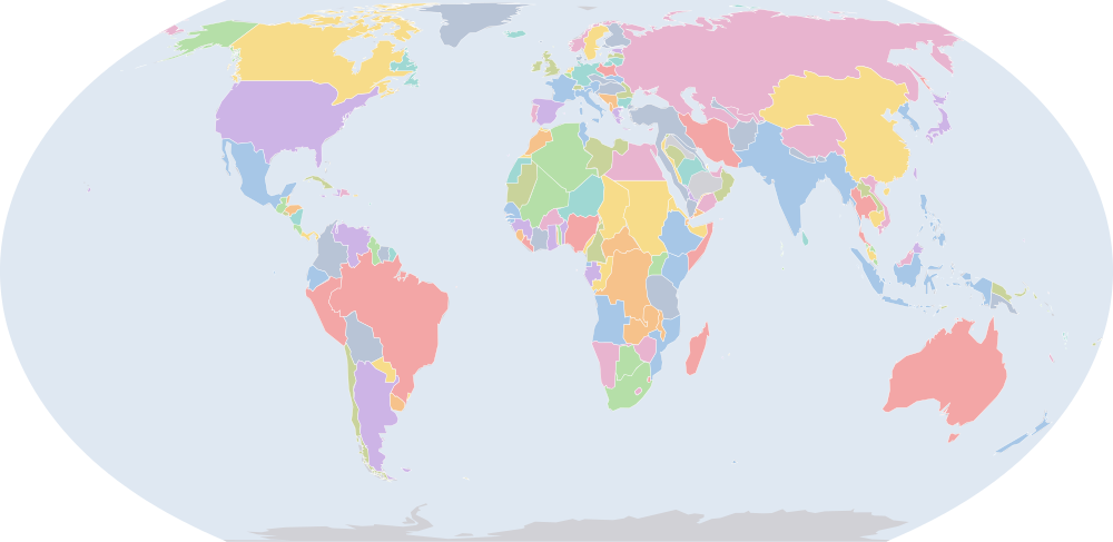
On 1 July 1919, IntMap’s historical map draws 206 names across the world. The borders for this date come from CShapes 2.0 (day by day), then OpenHistoricalMap (day by day), then Cliopatria, Seshat Global History Databank (by year) — each drawn only where the records before it are silent. It also draws 4 outlines whose name the record does not give for this date.
Why this year has a page
Among the largest year-to-year changes in the records the map dates by year or by day: 22 names begin or stop being drawn between 1 July 1918 and 1 July 1919.
The year of Treaty of Versailles (dated events index, Wikidata).
Names on the map
As the map labels them, largest first by the area of the outline drawn. Areas are of the drawn outline, rounded, and approximate. The record column says which record draws the outline; a Wikidata item is given where the record links one.
| Name | Record | Drawn area (km²) |
|---|---|---|
| Soviet Russia (RSFSR) | CShapes 2.0 | 21,300,000 |
| Canada | CShapes 2.0 | 9,530,000 |
| Republic of China | CShapes 2.0 | 9,060,000 |
| Brazil | CShapes 2.0 · OpenHistoricalMap Q155 | 8,520,000 |
| United States | CShapes 2.0 · OpenHistoricalMap Q30 | 7,940,000 |
| Australia | CShapes 2.0 | 7,710,000 |
| British Raj (British India) | CShapes 2.0 | 4,910,000 |
| Argentina | CShapes 2.0 · OpenHistoricalMap Q414 | 2,810,000 |
| Anglo-Egyptian Sudan | CShapes 2.0 | 2,590,000 |
| Algeria (France) | CShapes 2.0 | 2,450,000 |
| Denmark | CShapes 2.0 · OpenHistoricalMap Q35 | 2,360,000 |
| Belgian Congo (Belgium) | CShapes 2.0 | 2,340,000 |
| Mexico | CShapes 2.0 | 1,970,000 |
| Dutch East Indies | CShapes 2.0 | 1,900,000 |
| Tibet | CShapes 2.0 | 1,810,000 |
| Ottoman Empire | CShapes 2.0 · OpenHistoricalMap Q12560 | 1,800,000 |
| Persia | CShapes 2.0 | 1,620,000 |
| Egypt (UK) | CShapes 2.0 | 1,520,000 |
| Alaska (USA) | CShapes 2.0 | 1,500,000 |
| French Sudan (France) | CShapes 2.0 | 1,470,000 |
| Chad (France) | CShapes 2.0 | 1,280,000 |
| Angola (Portugal) | CShapes 2.0 | 1,250,000 |
| Peru | CShapes 2.0 | 1,250,000 |
| Union of South Africa | CShapes 2.0 | 1,220,000 |
| Bolivia | CShapes 2.0 | 1,200,000 |
| Niger (France) | CShapes 2.0 | 1,190,000 |
| Ethiopian Empire | CShapes 2.0 | 1,130,000 |
| Colombia | CShapes 2.0 | 1,100,000 |
| Tanganyika (UK) | CShapes 2.0 | 996,000 |
| Venezuela | CShapes 2.0 · Cliopatria Q717 | 929,000 |
| Libya (Italy) | CShapes 2.0 | 884,000 |
| Nigeria (UK) | CShapes 2.0 | 867,000 |
| Mauritania (France) | CShapes 2.0 | 829,000 |
| South West Africa (South Africa) | CShapes 2.0 | 827,000 |
| Mozambique (Portugal) | CShapes 2.0 | 790,000 |
| Northern Rhodesia (UK) | CShapes 2.0 | 755,000 |
| Chile | CShapes 2.0 | 749,000 |
| Afghanistan | CShapes 2.0 | 642,000 |
| British East Africa (UK) | CShapes 2.0 | 639,000 |
| Ubangi-Shari (France) | CShapes 2.0 | 621,000 |
| Madagascar (France) | CShapes 2.0 | 598,000 |
| Bechuanaland (UK) | CShapes 2.0 | 580,000 |
| French Third Republic | CShapes 2.0 · Cliopatria Q70802 | 557,000 |
| Siam | CShapes 2.0 | 515,000 |
| Spain | CShapes 2.0 | 507,000 |
| Weimar Republic | CShapes 2.0 | 476,000 |
| Sweden | CShapes 2.0 | 444,000 |
| French Cameroons (France) | CShapes 2.0 | 425,000 |
| Finland | CShapes 2.0 · OpenHistoricalMap Q33 | 424,000 |
| Emirate of Nejd | Cliopatria Q146862 | 421,000 |
All 206 names
| Name | Record | Drawn area (km²) |
|---|---|---|
| Newfoundland | CShapes 2.0 | 400,000 |
| Empire of Japan | CShapes 2.0 · OpenHistoricalMap | 397,000 |
| Southern Rhodesia (UK) | CShapes 2.0 | 391,000 |
| Italian Somaliland | CShapes 2.0 | 373,000 |
| Morocco (France) | CShapes 2.0 | 351,000 |
| French Congo (France) | CShapes 2.0 | 346,000 |
| Ecuador | CShapes 2.0 | 344,000 |
| Vietnam (France) | CShapes 2.0 | 327,000 |
| Cote d'Ivoire (France) | CShapes 2.0 | 323,000 |
| Norway | CShapes 2.0 | 322,000 |
| United Kingdom of Great Britain and Ireland | CShapes 2.0 | 316,000 |
| Muscat and Oman | CShapes 2.0 | 310,000 |
| Philippines (USA) | CShapes 2.0 | 299,000 |
| Paraguay | CShapes 2.0 | 294,000 |
| Kingdom of Italy | CShapes 2.0 · Cliopatria Q172579 | 288,000 |
| Uganda (UK) | CShapes 2.0 | 284,000 |
| Upper Volta (France) | CShapes 2.0 | 273,000 |
| New Zealand | CShapes 2.0 | 271,000 |
| Spanish West Africa | CShapes 2.0 | 270,000 |
| Gabon (France) | CShapes 2.0 | 263,000 |
| Hungary | CShapes 2.0 | 257,000 |
| Aden Protectorate | OpenHistoricalMap Q1865132 | 248,000 |
| French Guinea (France) | CShapes 2.0 | 246,000 |
| Emirate of Jabal Shammar | Cliopatria Q5362837 | 245,000 |
| Laos (France) | CShapes 2.0 | 231,000 |
| German New Guinea | CShapes 2.0 | 230,000 |
| Papua (Australia) | CShapes 2.0 | 226,000 |
| Korea (Japan) | CShapes 2.0 | 221,000 |
| Gold Coast (UK) | CShapes 2.0 | 213,000 |
| British Guiana (UK) | CShapes 2.0 | 212,000 |
| Austria | CShapes 2.0 | 212,000 |
| Senegal (France) | CShapes 2.0 | 197,000 |
| Emirate of Bukhara | CShapes 2.0 | 194,000 |
| Cambodia (France) | CShapes 2.0 | 183,000 |
| Uruguay | CShapes 2.0 | 178,000 |
| Poland | CShapes 2.0 | 177,000 |
| British Somaliland (UK) | CShapes 2.0 | 173,000 |
| Kingdom of Yugoslavia | CShapes 2.0 | 158,000 |
| Tunisia (France) | CShapes 2.0 | 156,000 |
| Nepal | CShapes 2.0 | 147,000 |
| Dutch Guiana (Netherlands) | CShapes 2.0 | 146,000 |
| Romania | CShapes 2.0 | 141,000 |
| Czechoslovakia | CShapes 2.0 | 140,000 |
| Yemen | CShapes 2.0 | 137,000 |
| Nicaragua | CShapes 2.0 | 129,000 |
| Sarawak | CShapes 2.0 | 125,000 |
| Greece | CShapes 2.0 | 124,000 |
| Eritrea (Italy) | CShapes 2.0 | 122,000 |
| Bulgaria | CShapes 2.0 | 119,000 |
| Nyasaland (UK) | CShapes 2.0 | 119,000 |
| Dahomey (France) | CShapes 2.0 | 117,000 |
| Kingdom of Hejaz | Cliopatria Q956357 | 115,000 |
| Honduras | CShapes 2.0 | 113,000 |
| Cuba | CShapes 2.0 | 111,000 |
| Guatemala | CShapes 2.0 | 109,000 |
| Iceland (Denmark) | CShapes 2.0 | 103,000 |
| Khanate of Khiva | CShapes 2.0 | 101,000 |
| Liberia | CShapes 2.0 | 96,500 |
| Portugal | CShapes 2.0 | 92,300 |
| British Cameroons | CShapes 2.0 | 87,900 |
| French Guiana (France) | CShapes 2.0 | 84,200 |
| Lithuania | CShapes 2.0 | 81,000 |
| Panama | CShapes 2.0 | 75,500 |
| North Borneo (UK) | CShapes 2.0 | 73,300 |
| Sierra Leone (UK) | CShapes 2.0 | 72,900 |
| British Empire | Cliopatria Q8680 | 72,600 |
| Federated Malay States | CShapes 2.0 | 71,900 |
| Trucial Oman (UK) | CShapes 2.0 | 70,900 |
| Ceylon (UK) | CShapes 2.0 | 66,800 |
| Latvia | CShapes 2.0 | 65,800 |
| French West Africa | OpenHistoricalMap Q210682 | 57,800 |
| Unfederated Malay States | CShapes 2.0 | 57,600 |
| Spanish Morocco | CShapes 2.0 | 53,300 |
| Russian Soviet Federative Socialist Republic | OpenHistoricalMap Q2184 | 52,300 |
| Costa Rica | CShapes 2.0 | 51,600 |
| Estonia | CShapes 2.0 | 49,300 |
| Dominican Republic | CShapes 2.0 | 48,700 |
| North Yemen | Cliopatria Q1998401 | 45,000 |
| Switzerland | CShapes 2.0 | 41,400 |
| Bhutan | CShapes 2.0 | 39,900 |
| Taiwan (Japan) | CShapes 2.0 | 36,200 |
| Netherlands | CShapes 2.0 | 35,000 |
| Karafuto (Japan) | CShapes 2.0 | 33,800 |
| Portuguese Guinea (Portugal) | CShapes 2.0 | 33,600 |
| Maldives Protectorate | OpenHistoricalMap Q1074669 | 31,300 |
| Basutoland (UK) | CShapes 2.0 | 30,600 |
| Belgium | CShapes 2.0 | 30,500 |
| Albania | CShapes 2.0 | 28,700 |
| New Hebrides / Nouvelles-Hébrides | OpenHistoricalMap Q752431 | 28,300 |
| British Solomon Islands (UK) | CShapes 2.0 | 27,800 |
| Haiti | CShapes 2.0 | 27,500 |
| Spanish Guinea (Spain) | CShapes 2.0 | 27,200 |
| German Togoland | CShapes 2.0 | 26,700 |
| New Caledonia (France) | CShapes 2.0 | 24,000 |
| British Honduras (UK) | CShapes 2.0 | 22,300 |
| Protectorate of Kuwait | OpenHistoricalMap Q817 | 22,200 |
| French Somaliland (France) | CShapes 2.0 | 21,600 |
| El Salvador | CShapes 2.0 | 20,700 |
| Fiji (UK) | CShapes 2.0 | 18,500 |
| Hawaii (USA) | CShapes 2.0 | 17,300 |
| Swaziland (UK) | CShapes 2.0 | 17,100 |
| British Western Pacific Territories | OpenHistoricalMap Q1545934 | 15,700 |
| Asir | Cliopatria | 15,300 |
| Portuguese Timor (Portugal) | CShapes 2.0 | 15,300 |
| Gilbert and Ellice Islands Colony | OpenHistoricalMap Q1050859 | 15,100 |
| Australian occupation of German New Guinea | OpenHistoricalMap Q4825066 | 14,100 |
| French Polynesia (France) | CShapes 2.0 | 13,000 |
| Bahamas (UK) | CShapes 2.0 | 12,800 |
| Jamaica (UK) | CShapes 2.0 | 11,200 |
| Qatar (UK) | CShapes 2.0 | 11,100 |
| Gambia (UK) | CShapes 2.0 | 10,900 |
| Brazilian Republic | Cliopatria Q155 | 10,700 |
| Puerto Rico (USA) | CShapes 2.0 | 9,310 |
| Cyprus | CShapes 2.0 | 9,300 |
| Protectorate of Tonga | OpenHistoricalMap Q23022146 | 8,310 |
| British Colonial Empire | Cliopatria Q8680 | 8,180 |
| British Africa | Cliopatria | 7,900 |
| Colony of Seychelles | OpenHistoricalMap Q1042 | 7,520 |
| British Guiana | OpenHistoricalMap Q1796551 | 6,900 |
| Sultanate of Lahej | OpenHistoricalMap Q404774 | 5,970 |
| Zanzibar Protectorate | OpenHistoricalMap Q3574782 | 5,780 |
| Brunei (UK) | CShapes 2.0 | 5,770 |
| British occupation of German Samoa | OpenHistoricalMap Q2081983 | 5,240 |
| Dominion of New Zealand | OpenHistoricalMap Q2594990 | 5,240 |
| Trinidad and Tobago (UK) | CShapes 2.0 | 5,240 |
| British Windward Islands | OpenHistoricalMap Q2660774 | 4,870 |
| Colony of Guadelupe | OpenHistoricalMap Q17012 | 4,740 |
| Cook Islands | OpenHistoricalMap Q26988 | 4,410 |
| Cape Verde | CShapes 2.0 | 4,040 |
| La Réunion | OpenHistoricalMap Q17070 | 3,930 |
| Straits Settlements | CShapes 2.0 | 3,700 |
| British Hong Kong | OpenHistoricalMap Q1054923 | 2,900 |
| Reunion (France) | CShapes 2.0 | 2,650 |
| British Solomon Islands Protectorate | OpenHistoricalMap Q13410267 | 2,620 |
| Sultanate of Zanzibar | CShapes 2.0 | 2,600 |
| Luxembourg | CShapes 2.0 | 2,570 |
| Portuguese São Tomé and Príncipe | OpenHistoricalMap Q7232692 | 2,560 |
| Mauritius (UK) | CShapes 2.0 | 2,160 |
| Kwangchowan | OpenHistoricalMap Q1506615 | 2,120 |
| Danzig | CShapes 2.0 | 2,030 |
| Guadeloupe (France) | CShapes 2.0 | 1,660 |
| Cayman Islands | OpenHistoricalMap Q5785 | 1,520 |
| Isle of Man | OpenHistoricalMap Q9676 | 1,350 |
| Martinique (France) | CShapes 2.0 | 1,200 |
| Saint Pierre and Miquelon | OpenHistoricalMap Q34617 | 1,100 |
| Wallis and Futuna Colony | OpenHistoricalMap Q35555 | 1,010 |
| Jersey | OpenHistoricalMap Q785 | 986 |
| Guernsey | OpenHistoricalMap Q25230 | 909 |
| French Settlements in India | OpenHistoricalMap Q646374 | 727 |
| Pitcairn Islands | OpenHistoricalMap Q35672 | 691 |
| Colony of Bermuda | OpenHistoricalMap Q23635 | 557 |
| Saint Helena Crown Colony | OpenHistoricalMap Q192184 | 507 |
| Barbados (UK) | CShapes 2.0 | 457 |
| Malta | CShapes 2.0 | 292 |
| Australian occupation of Nauru | OpenHistoricalMap Q697 | 216 |
| Maldives (UK) | CShapes 2.0 | 27.8 |
What changed since 1917
Names counted are those the records date to the year or the day (CShapes, OpenHistoricalMap, Cliopatria). Outlines filled from the nearest historical-basemaps sheet are counted only when both years are years that sheet was drawn for — otherwise the change would be the switch between two sheets, not a change in the world. Names are compared as written, so a polity a record names differently in the two years (Carthaginian Empire, then Carthage) is in both lists.
Now drawn (21)
Soviet Russia (RSFSR), Tanganyika (UK), Weimar Republic, French Cameroons (France), Finland, Upper Volta (France), Hungary, Austria, Poland, Kingdom of Yugoslavia, Czechoslovakia, Yemen, British Cameroons, Lithuania, Latvia, French West Africa, Russian Soviet Federative Socialist Republic, Estonia, North Yemen, British Africa, Danzig
No longer drawn (8)
Russian Empire, German East Africa, Kamerun, Austria-Hungary, German Empire, Serbia, Japanese occupation of German colonial possessions, Montenegro
Events dated to 1919
Every record of IntMap’s one index of dated events whose date falls in this year: what the border record (CShapes 2.0) states about its own outlines, IntMap’s war record, and the world events Wikidata dates — each with its source and the precision of its date.
- 1919
The map begins drawing Upper Volta (France); new borders for French Sudan (France)
the border record (CShapes 2.0) · 1919-03-01
On this day → - 1919
The map begins drawing Tanganyika (UK), French Cameroons (France), British Cameroons and 1 more; the map stops drawing German East Africa, Kamerun; new borders for Chad (France), Ubangi-Shari (France), French Third Republic and 5 more
the border record (CShapes 2.0) · 1919-06-28
On this day → - 1919
Treaty of Versailles
most important of the peace treaties of the First World War which ended the state of war between Germany and the Allied Powers
1919-06-28 · Wikidata Q8736
- 1919
New borders for Kingdom of Italy, Poland, Kingdom of Yugoslavia and 1 more
the border record (CShapes 2.0) · 1919-09-10
On this day → - 1919
New borders for Algeria (France), Libya (Italy)
the border record (CShapes 2.0) · 1919-09-12
On this day → - 1919
Sources and method
Borders and names: CShapes 2.0 (Schvitz et al. 2022, icr.ethz.ch/data/cshapes) · CC BY-NC-SA 4.0 + OpenHistoricalMap (openhistoricalmap.org) · CC0 1.0 · adapted by IntMap: the admin_level=2 relations in force from 1886, less the ground CShapes states on its own dates + Cliopatria v0.2.1 (Seshat Global History Databank, github.com/Seshat-Global-History-Databank/cliopatria) · CC BY 4.0 · adapted by IntMap: simplified, BC years made astronomical, and the ground OpenHistoricalMap (1689–1885, and from 1886 where CShapes is silent) and CShapes (1886–2019) state removed on their own dates.
Which years have a page is worked out when the site is built, from three rules applied to the records themselves: every year the historical-basemaps atlas drew a world sheet for; every year whose change from the year before (names the dated records begin or stop drawing) is in the top 5% of all such year-to-year changes since the dated records begin, leaving out the years where one record hands over to another; and every year of a geopolitical, war or revolution event in the dated events index, up to the last year the border records cover (2019).
On each year the map is read on 1 July, the instant the app’s own year links open on. Names are the source’s own, translated where the source or IntMap’s name table has a translation. A name is what a record draws there, not a verdict of history.
World map in 1919 — the map, with the years it stays the same Historical maps by region Countries On this day