The world in 1917
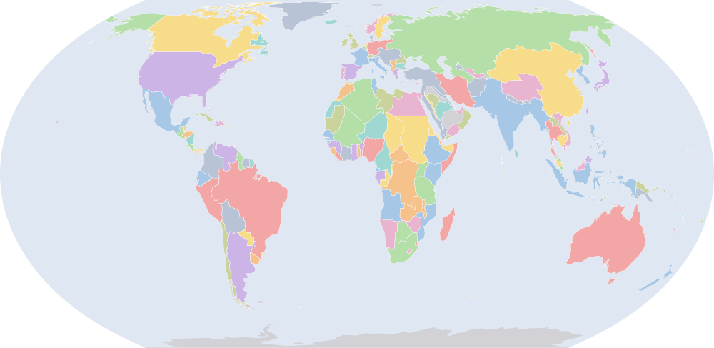
On 1 July 1917, IntMap’s historical map draws 193 names across the world. The borders for this date come from CShapes 2.0 (day by day), then OpenHistoricalMap (day by day), then Cliopatria, Seshat Global History Databank (by year) — each drawn only where the records before it are silent. It also draws 4 outlines whose name the record does not give for this date.
Why this year has a page
The year of Russian Revolution (dated events index, Wikidata).
Names on the map
As the map labels them, largest first by the area of the outline drawn. Areas are of the drawn outline, rounded, and approximate. The record column says which record draws the outline; a Wikidata item is given where the record links one.
| Name | Record | Drawn area (km²) |
|---|---|---|
| Russian Empire | CShapes 2.0 · OpenHistoricalMap Q34266 | 22,100,000 |
| Canada | CShapes 2.0 | 9,530,000 |
| Republic of China | CShapes 2.0 | 9,060,000 |
| Brazil | CShapes 2.0 · OpenHistoricalMap Q155 | 8,520,000 |
| United States | CShapes 2.0 · OpenHistoricalMap Q30 | 7,940,000 |
| Australia | CShapes 2.0 | 7,710,000 |
| British Raj (British India) | CShapes 2.0 | 4,910,000 |
| Argentina | CShapes 2.0 · OpenHistoricalMap Q414 | 2,810,000 |
| Anglo-Egyptian Sudan | CShapes 2.0 | 2,590,000 |
| Algeria (France) | CShapes 2.0 | 2,450,000 |
| Denmark | CShapes 2.0 · OpenHistoricalMap Q35 | 2,360,000 |
| Belgian Congo (Belgium) | CShapes 2.0 | 2,340,000 |
| Ottoman Empire | CShapes 2.0 · OpenHistoricalMap · Cliopatria Q12560 | 1,980,000 |
| Mexico | CShapes 2.0 | 1,970,000 |
| Dutch East Indies | CShapes 2.0 | 1,900,000 |
| Tibet | CShapes 2.0 | 1,810,000 |
| French Sudan (France) | CShapes 2.0 | 1,740,000 |
| Persia | CShapes 2.0 | 1,620,000 |
| Egypt (UK) | CShapes 2.0 | 1,520,000 |
| Alaska (USA) | CShapes 2.0 | 1,500,000 |
| Angola (Portugal) | CShapes 2.0 | 1,250,000 |
| Peru | CShapes 2.0 | 1,250,000 |
| Chad (France) | CShapes 2.0 | 1,230,000 |
| Union of South Africa | CShapes 2.0 | 1,220,000 |
| Bolivia | CShapes 2.0 | 1,200,000 |
| Niger (France) | CShapes 2.0 | 1,190,000 |
| Ethiopian Empire | CShapes 2.0 | 1,130,000 |
| Colombia | CShapes 2.0 | 1,100,000 |
| German East Africa | CShapes 2.0 | 996,000 |
| Venezuela | CShapes 2.0 · Cliopatria Q717 | 929,000 |
| Libya (Italy) | CShapes 2.0 | 884,000 |
| Nigeria (UK) | CShapes 2.0 | 867,000 |
| Mauritania (France) | CShapes 2.0 | 829,000 |
| South West Africa (South Africa) | CShapes 2.0 | 827,000 |
| Kamerun | CShapes 2.0 | 804,000 |
| Mozambique (Portugal) | CShapes 2.0 | 790,000 |
| Northern Rhodesia (UK) | CShapes 2.0 | 755,000 |
| Chile | CShapes 2.0 | 749,000 |
| Austria-Hungary | CShapes 2.0 | 674,000 |
| Afghanistan | CShapes 2.0 | 642,000 |
| British East Africa (UK) | CShapes 2.0 | 639,000 |
| Madagascar (France) | CShapes 2.0 | 598,000 |
| Bechuanaland (UK) | CShapes 2.0 | 580,000 |
| German Empire | CShapes 2.0 | 542,000 |
| French Third Republic | CShapes 2.0 · Cliopatria Q70802 | 542,000 |
| Siam | CShapes 2.0 | 515,000 |
| Spain | CShapes 2.0 | 507,000 |
| Ubangi-Shari (France) | CShapes 2.0 | 498,000 |
| Sweden | CShapes 2.0 | 444,000 |
| Emirate of Nejd | Cliopatria Q146862 | 421,000 |
All 193 names
| Name | Record | Drawn area (km²) |
|---|---|---|
| Newfoundland | CShapes 2.0 | 400,000 |
| Empire of Japan | CShapes 2.0 · OpenHistoricalMap | 393,000 |
| Southern Rhodesia (UK) | CShapes 2.0 | 391,000 |
| Italian Somaliland | CShapes 2.0 | 373,000 |
| Morocco (France) | CShapes 2.0 | 351,000 |
| Ecuador | CShapes 2.0 | 344,000 |
| Vietnam (France) | CShapes 2.0 | 327,000 |
| Cote d'Ivoire (France) | CShapes 2.0 | 323,000 |
| Norway | CShapes 2.0 | 322,000 |
| United Kingdom of Great Britain and Ireland | CShapes 2.0 | 316,000 |
| Muscat and Oman | CShapes 2.0 | 310,000 |
| Philippines (USA) | CShapes 2.0 | 299,000 |
| Paraguay | CShapes 2.0 | 294,000 |
| Kingdom of Italy | CShapes 2.0 · Cliopatria Q172579 | 288,000 |
| Uganda (UK) | CShapes 2.0 | 284,000 |
| New Zealand | CShapes 2.0 | 271,000 |
| Spanish West Africa | CShapes 2.0 | 270,000 |
| French Congo (France) | CShapes 2.0 | 264,000 |
| Aden Protectorate | OpenHistoricalMap Q1865132 | 249,000 |
| French Guinea (France) | CShapes 2.0 | 246,000 |
| Emirate of Jabal Shammar | Cliopatria Q5362837 | 245,000 |
| Laos (France) | CShapes 2.0 | 231,000 |
| German New Guinea | CShapes 2.0 | 230,000 |
| Gabon (France) | CShapes 2.0 | 228,000 |
| Papua (Australia) | CShapes 2.0 | 226,000 |
| Korea (Japan) | CShapes 2.0 | 221,000 |
| Gold Coast (UK) | CShapes 2.0 | 213,000 |
| British Guiana (UK) | CShapes 2.0 | 212,000 |
| Senegal (France) | CShapes 2.0 | 197,000 |
| Emirate of Bukhara | CShapes 2.0 | 194,000 |
| Cambodia (France) | CShapes 2.0 | 183,000 |
| Uruguay | CShapes 2.0 | 178,000 |
| British Somaliland (UK) | CShapes 2.0 | 173,000 |
| Tunisia (France) | CShapes 2.0 | 156,000 |
| Nepal | CShapes 2.0 | 147,000 |
| Dutch Guiana (Netherlands) | CShapes 2.0 | 146,000 |
| Romania | CShapes 2.0 | 136,000 |
| Nicaragua | CShapes 2.0 | 129,000 |
| Sarawak | CShapes 2.0 | 125,000 |
| Greece | CShapes 2.0 | 124,000 |
| Eritrea (Italy) | CShapes 2.0 | 122,000 |
| Nyasaland (UK) | CShapes 2.0 | 119,000 |
| Dahomey (France) | CShapes 2.0 | 117,000 |
| Honduras | CShapes 2.0 | 113,000 |
| Bulgaria | CShapes 2.0 | 111,000 |
| Cuba | CShapes 2.0 | 111,000 |
| Guatemala | CShapes 2.0 | 109,000 |
| Iceland (Denmark) | CShapes 2.0 | 103,000 |
| Khanate of Khiva | CShapes 2.0 | 101,000 |
| Liberia | CShapes 2.0 | 96,500 |
| Kingdom of Hejaz | Cliopatria Q956357 | 92,700 |
| Portugal | CShapes 2.0 | 92,300 |
| Serbia | CShapes 2.0 | 90,500 |
| French Guiana (France) | CShapes 2.0 | 84,200 |
| German Togoland | CShapes 2.0 | 84,100 |
| Panama | CShapes 2.0 | 75,500 |
| North Borneo (UK) | CShapes 2.0 | 73,300 |
| Sierra Leone (UK) | CShapes 2.0 | 72,900 |
| Federated Malay States | CShapes 2.0 | 71,900 |
| Trucial Oman (UK) | CShapes 2.0 | 70,900 |
| Ceylon (UK) | CShapes 2.0 | 66,800 |
| Unfederated Malay States | CShapes 2.0 | 57,600 |
| Spanish Morocco | CShapes 2.0 | 53,300 |
| Costa Rica | CShapes 2.0 | 51,600 |
| Japanese occupation of German colonial possessions | OpenHistoricalMap Q4342049 | 50,000 |
| British Empire | Cliopatria Q8680 | 49,300 |
| Dominican Republic | CShapes 2.0 | 48,700 |
| Switzerland | CShapes 2.0 | 41,400 |
| Bhutan | CShapes 2.0 | 39,900 |
| Taiwan (Japan) | CShapes 2.0 | 36,200 |
| Netherlands | CShapes 2.0 | 35,000 |
| Karafuto (Japan) | CShapes 2.0 | 33,800 |
| Portuguese Guinea (Portugal) | CShapes 2.0 | 33,600 |
| Maldives Protectorate | OpenHistoricalMap Q1074669 | 31,300 |
| Basutoland (UK) | CShapes 2.0 | 30,600 |
| Belgium | CShapes 2.0 | 30,500 |
| Albania | CShapes 2.0 | 28,700 |
| New Hebrides / Nouvelles-Hébrides | OpenHistoricalMap Q752431 | 28,300 |
| British Solomon Islands (UK) | CShapes 2.0 | 27,800 |
| Haiti | CShapes 2.0 | 27,500 |
| Spanish Guinea (Spain) | CShapes 2.0 | 27,200 |
| New Caledonia (France) | CShapes 2.0 | 24,000 |
| British Honduras (UK) | CShapes 2.0 | 22,300 |
| Protectorate of Kuwait | OpenHistoricalMap Q817 | 22,200 |
| French Somaliland (France) | CShapes 2.0 | 21,600 |
| El Salvador | CShapes 2.0 | 20,700 |
| Fiji (UK) | CShapes 2.0 | 18,500 |
| Hawaii (USA) | CShapes 2.0 | 17,300 |
| Swaziland (UK) | CShapes 2.0 | 17,100 |
| Montenegro | CShapes 2.0 | 15,900 |
| British Western Pacific Territories | OpenHistoricalMap Q1545934 | 15,700 |
| Asir | Cliopatria | 15,300 |
| Portuguese Timor (Portugal) | CShapes 2.0 | 15,300 |
| Australian occupation of German New Guinea | OpenHistoricalMap Q4825066 | 14,100 |
| French Polynesia (France) | CShapes 2.0 | 13,000 |
| Bahamas (UK) | CShapes 2.0 | 12,800 |
| Gilbert and Ellice Islands Colony | OpenHistoricalMap Q1050859 | 11,800 |
| Jamaica (UK) | CShapes 2.0 | 11,200 |
| Qatar (UK) | CShapes 2.0 | 11,100 |
| Gambia (UK) | CShapes 2.0 | 10,900 |
| Brazilian Republic | Cliopatria Q155 | 10,700 |
| Puerto Rico (USA) | CShapes 2.0 | 9,310 |
| Cyprus | CShapes 2.0 | 9,300 |
| Protectorate of Tonga | OpenHistoricalMap Q23022146 | 8,310 |
| British Colonial Empire | Cliopatria Q8680 | 8,180 |
| Colony of Seychelles | OpenHistoricalMap Q1042 | 7,520 |
| British Guiana | OpenHistoricalMap Q1796551 | 6,900 |
| Sultanate of Lahej | OpenHistoricalMap Q404774 | 5,980 |
| Zanzibar Protectorate | OpenHistoricalMap Q3574782 | 5,780 |
| Brunei (UK) | CShapes 2.0 | 5,770 |
| British occupation of German Samoa | OpenHistoricalMap Q2081983 | 5,240 |
| Dominion of New Zealand | OpenHistoricalMap Q2594990 | 5,240 |
| Trinidad and Tobago (UK) | CShapes 2.0 | 5,240 |
| British Windward Islands | OpenHistoricalMap Q2660774 | 4,870 |
| Colony of Guadelupe | OpenHistoricalMap Q17012 | 4,740 |
| Cook Islands | OpenHistoricalMap Q26988 | 4,410 |
| Cape Verde | CShapes 2.0 | 4,040 |
| La Réunion | OpenHistoricalMap Q17070 | 3,930 |
| Straits Settlements | CShapes 2.0 | 3,700 |
| British Hong Kong | OpenHistoricalMap Q1054923 | 2,900 |
| Reunion (France) | CShapes 2.0 | 2,650 |
| British Solomon Islands Protectorate | OpenHistoricalMap Q13410267 | 2,620 |
| Sultanate of Zanzibar | CShapes 2.0 | 2,600 |
| Luxembourg | CShapes 2.0 | 2,570 |
| Portuguese São Tomé and Príncipe | OpenHistoricalMap Q7232692 | 2,560 |
| Mauritius (UK) | CShapes 2.0 | 2,160 |
| Kwangchowan | OpenHistoricalMap Q1506615 | 2,120 |
| Guadeloupe (France) | CShapes 2.0 | 1,660 |
| Cayman Islands | OpenHistoricalMap Q5785 | 1,520 |
| Isle of Man | OpenHistoricalMap Q9676 | 1,350 |
| Martinique (France) | CShapes 2.0 | 1,200 |
| Saint Pierre and Miquelon | OpenHistoricalMap Q34617 | 1,100 |
| Wallis and Futuna Colony | OpenHistoricalMap Q35555 | 1,010 |
| Jersey | OpenHistoricalMap Q785 | 986 |
| Guernsey | OpenHistoricalMap Q25230 | 909 |
| French Settlements in India | OpenHistoricalMap Q646374 | 727 |
| Pitcairn Islands | OpenHistoricalMap Q35672 | 691 |
| Colony of Bermuda | OpenHistoricalMap Q23635 | 557 |
| Saint Helena Crown Colony | OpenHistoricalMap Q192184 | 507 |
| Barbados (UK) | CShapes 2.0 | 457 |
| Malta | CShapes 2.0 | 292 |
| Australian occupation of Nauru | OpenHistoricalMap Q697 | 216 |
| Maldives (UK) | CShapes 2.0 | 27.8 |
What changed since 1914
Names counted are those the records date to the year or the day (CShapes, OpenHistoricalMap, Cliopatria). Outlines filled from the nearest historical-basemaps sheet are counted only when both years are years that sheet was drawn for — otherwise the change would be the switch between two sheets, not a change in the world. Names are compared as written, so a polity a record names differently in the two years (Carthaginian Empire, then Carthage) is in both lists.
Now drawn (12)
South West Africa (South Africa), Kingdom of Hejaz, Japanese occupation of German colonial possessions, Asir, Australian occupation of German New Guinea, Gilbert and Ellice Islands Colony, Qatar (UK), Cyprus, British occupation of German Samoa, Dominion of New Zealand, Wallis and Futuna Colony, Australian occupation of Nauru
No longer drawn (7)
German South-West Africa, Qatar, Gilbert and Ellice Islands Protectorate, German Samoa, Protectorate of Bahrain, Danish West Indies, Tokelau Islands Protectorate
Events dated to 1917
Every record of IntMap’s one index of dated events whose date falls in this year: what the border record (CShapes 2.0) states about its own outlines, IntMap’s war record, and the world events Wikidata dates — each with its source and the precision of its date.
- 1917
- 1917
Battle of Rafa — the last Ottoman post in Sinai falls and the campaign crosses the frontier
IntMap’s war record — World War I · 1917-01-09
On this day → - 1917
Germany resumes unrestricted submarine warfare — the decision that brings the United States in
IntMap’s war record — World War I · 1917-02-01
On this day → - 1917
Second Battle of Kut — Maude retakes the town where an army surrendered ten months earlier
IntMap’s war record — World War I · 1917-02-23
On this day → - 1917
The Zimmermann telegram is published — Germany had offered Mexico an alliance against the United States
IntMap’s war record — World War I · 1917-03-01
On this day → - 1917
The February Revolution — the Tsar abdicates
IntMap’s war record — World War I · 1917-03-08 – 1917-03-16
On this day → - 1917
- 1917
First Battle of Gaza — the town is all but taken and then given back the same evening
IntMap’s war record — World War I · 1917-03-26
On this day → - 1917
The United States declares war on Germany
IntMap’s war record — World War I · 1917-04-06
On this day → - 1917
- 1917
Vimy Ridge — the four Canadian divisions attack together for the first time and take the ridge
IntMap’s war record — World War I · 1917-04-09 – 1917-04-12
On this day → - 1917
The Nivelle Offensive — its failure sets off mutinies in half the French army
IntMap’s war record — World War I · 1917-04-16 – 1917-05-09
On this day → - 1917
Second Battle of Gaza — a frontal attack with gas and tanks fails in three days
IntMap’s war record — World War I · 1917-04-17 – 1917-04-19
On this day → - 1917
First Battle of Doiran — the British attack the Bulgarian hill line twice and gain nothing
IntMap’s war record — World War I · 1917-04-22 – 1917-05-09
On this day → - 1917
The French Army mutinies — half the divisions of the French army refuse to attack again
IntMap’s war record — World War I · 1917-04-25 – 1917-06-08
On this day → - 1917
The Strait of Otranto — the largest surface action of the Adriatic, fought over the drifter barrage
IntMap’s war record — World War I · 1917-05-15
On this day → - 1917
The Gotha daylight raids — bombers replace the airships and London is hit in broad daylight
IntMap’s war record — World War I · 1917-05-25 – 1918-05-20
On this day → - 1917
Messines — nineteen mines under the ridge, heard in London
IntMap’s war record — World War I · 1917-06-07 – 1917-06-14
On this day → - 1917
Greece enters the war — the National Schism ends with the king gone and Venizelos in Athens
IntMap’s war record — World War I · 1917-06-29
On this day → - 1917
The Kerensky Offensive — the last Russian attack of the war, and the army breaks up behind it
IntMap’s war record — World War I · 1917-07-01 – 1917-07-19
On this day → - 1917
The capture of Aqaba — the Arab force takes the port from the desert side, where there are no guns
IntMap’s war record — World War I · 1917-07-06
On this day → - 1917
Battle of Mărăști — the reorganised Romanian army attacks and advances for the first time
IntMap’s war record — World War I · 1917-07-22 – 1917-08-01
On this day → - 1917
- 1917
Battle of Mărășești — the German drive on Iași is held, and Romania keeps a corner of itself
IntMap’s war record — World War I · 1917-08-06 – 1917-09-03
On this day → - 1917
Eleventh Battle of the Isonzo — Italy takes the Bainsizza plateau and exhausts both armies
IntMap’s war record — World War I · 1917-08-18 – 1917-09-12
On this day → - 1917
The Riga offensive — a river crossing behind a hurricane barrage, the method of 1918 tried out
IntMap’s war record — World War I · 1917-09-01 – 1917-09-05
On this day → - 1917
The Kornilov affair — a march on Petrograd that fails, and arms the Bolsheviks who stop it
IntMap’s war record — World War I · 1917-09-10 – 1917-09-13
On this day → - 1917
The battles of Ramadi — the Euphrates garrison is trapped against the river at the second attempt
IntMap’s war record — World War I · 1917-09-28 – 1917-09-29
On this day → - 1917
Operation Albion — the German landing on the Baltic islands, the war’s largest combined operation
IntMap’s war record — World War I · 1917-10-12 – 1917-10-20
On this day → - 1917
Battle of Mahiwa — the bloodiest action of the East African campaign, won by the side that had to retreat
IntMap’s war record — World War I · 1917-10-15 – 1917-10-18
On this day → - 1917
- 1917
Beersheba — the wells are taken before they can be blown, and the Gaza line is turned
IntMap’s war record — World War I · 1917-10-31
On this day → - 1917
Third Battle of Gaza — the town falls at the third attempt and the road to Jerusalem opens
IntMap’s war record — World War I · 1917-11-01 – 1917-11-02
On this day → - 1917
The Balfour Declaration — Britain declares itself in favour of a Jewish national home in Palestine
IntMap’s war record — World War I · 1917-11-02
On this day → - 1917
- 1917
The Supreme War Council is set up at Versailles — one command for the whole Allied war at last
IntMap’s war record — World War I · 1917-11-07
On this day → - 1917
Monte Grappa — the mountain anchor of the Piave line, held through two winters
IntMap’s war record — World War I · 1917-11-11 – 1917-12-23
On this day → - 1917
Second Heligoland Bight — a running fight over the German minesweepers, broken off at the minefields
IntMap’s war record — World War I · 1917-11-17
On this day → - 1917
Cambrai — the first mass tank attack, and the first German counter-attack to take it all back
IntMap’s war record — World War I · 1917-11-20 – 1917-12-07
On this day → - 1917
Battle of Ngomano — the German force crosses the Rovuma into Portuguese territory and re-equips from the garrison it destroys
IntMap’s war record — World War I · 1917-11-25
On this day → - 1917
The map begins drawing Finland; new borders for Soviet Russia (RSFSR)
the border record (CShapes 2.0) · 1917-12-06
On this day → - 1917
- 1917
Battle of Jaffa — the Auja is crossed at night and the port is put out of shellfire
IntMap’s war record — World War I · 1917-12-20 – 1917-12-21
On this day →
Sources and method
Borders and names: CShapes 2.0 (Schvitz et al. 2022, icr.ethz.ch/data/cshapes) · CC BY-NC-SA 4.0 + OpenHistoricalMap (openhistoricalmap.org) · CC0 1.0 · adapted by IntMap: the admin_level=2 relations in force from 1886, less the ground CShapes states on its own dates + Cliopatria v0.2.1 (Seshat Global History Databank, github.com/Seshat-Global-History-Databank/cliopatria) · CC BY 4.0 · adapted by IntMap: simplified, BC years made astronomical, and the ground OpenHistoricalMap (1689–1885, and from 1886 where CShapes is silent) and CShapes (1886–2019) state removed on their own dates.
Which years have a page is worked out when the site is built, from three rules applied to the records themselves: every year the historical-basemaps atlas drew a world sheet for; every year whose change from the year before (names the dated records begin or stop drawing) is in the top 5% of all such year-to-year changes since the dated records begin, leaving out the years where one record hands over to another; and every year of a geopolitical, war or revolution event in the dated events index, up to the last year the border records cover (2019).
On each year the map is read on 1 July, the instant the app’s own year links open on. Names are the source’s own, translated where the source or IntMap’s name table has a translation. A name is what a record draws there, not a verdict of history.
World map in 1917 — the map, with the years it stays the same Historical maps by region Countries On this day