The world in 1260
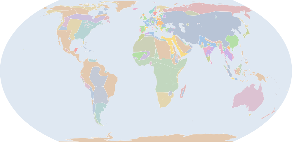
On 1 July 1260, IntMap’s historical map draws 231 names across the world. The borders for this date come from Cliopatria, Seshat Global History Databank (by year), then historical-basemaps — each drawn only where the records before it are silent. It also draws 94 outlines whose name the record does not give for this date.
Why this year has a page
Among the largest year-to-year changes in the records the map dates by year or by day: 31 names begin or stop being drawn between 1 July 1259 and 1 July 1260.
Names on the map
As the map labels them, largest first by the area of the outline drawn. Areas are of the drawn outline, rounded, and approximate. The record column says which record draws the outline; a Wikidata item is given where the record links one.
| Name | Record | Drawn area (km²) |
|---|---|---|
| Mongol Empire | Cliopatria Q12557 | 25,800,000 |
| Bantou | historical-basemaps | 8,450,000 |
| Siberians | historical-basemaps | 7,650,000 |
| Australian aboriginal hunter-gatherers (a description by the source, not a name) | historical-basemaps | 7,600,000 |
| Touareg | historical-basemaps | 4,280,000 |
| West African cereal farmers (a description by the source, not a name) | historical-basemaps | 4,190,000 |
| Eastern North Amercian hunter-gatherers (a description by the source, not a name) | historical-basemaps | 3,540,000 |
| Amazon hunter-gatherers (a description by the source, not a name) | historical-basemaps | 3,200,000 |
| Savanna hunter-gatherers (a description by the source, not a name) | historical-basemaps | 3,040,000 |
| Plain bison hunters (a description by the source, not a name) | historical-basemaps | 2,620,000 |
| Subarctic forest hunter-gatherers (a description by the source, not a name) | historical-basemaps | 2,500,000 |
| Khoiasan | historical-basemaps | 2,490,000 |
| Thule | historical-basemaps | 2,380,000 |
| Pampas cultures (a description by the source, not a name) | historical-basemaps | 1,830,000 |
| Southern Song | Cliopatria Q7462 | 1,740,000 |
| Mamluk Sultanate | Cliopatria Q282428 | 1,350,000 |
| Mamluk Dynasty | Cliopatria Q847420 | 1,350,000 |
| Delhi Sultanate | Cliopatria Q229411 | 1,350,000 |
| Athabaskan | historical-basemaps | 1,200,000 |
| Holy Roman Empire | Cliopatria · historical-basemaps Q12548 | 992,000 |
| Mali Empire | Cliopatria Q184536 | 977,000 |
| Mali | historical-basemaps | 798,000 |
| Khanate of the Golden Horde | historical-basemaps | 777,000 |
| Plateau fichers and hunter gatherers (a description by the source, not a name) | historical-basemaps | 677,000 |
| Kingdom of France | Cliopatria Q70972 | 645,000 |
| minor Hindu kingdoms (a description by the source, not a name) | historical-basemaps | 519,000 |
| Khmer Empire | Cliopatria · historical-basemaps Q201705 | 519,000 |
| Holy Roman Empire Minor States | Cliopatria Q12548 | 516,000 |
| Novgorod | historical-basemaps | 495,000 |
| Dorset | historical-basemaps | 493,000 |
| Sámi | historical-basemaps | 490,000 |
| Yadava Dynasty | Cliopatria Q5790 | 486,000 |
| Srivijaya | Cliopatria Q234197 | 462,000 |
| Kingdom of England | Cliopatria Q179876 | 450,000 |
| Andean hunter-gatherers (a description by the source, not a name) | historical-basemaps | 447,000 |
| Pagan Kingdom | Cliopatria Q888574 | 441,000 |
| Desert hunter-gatherers (a description by the source, not a name) | historical-basemaps | 436,000 |
| North American Pacifi foraging, hunting and fishing peoples | historical-basemaps | 435,000 |
| Madagascar | historical-basemaps | 431,000 |
| Andean states and chiefdoms (a description by the source, not a name) | historical-basemaps | 427,000 |
| Almohad Caliphate | Cliopatria Q199688 | 389,000 |
| Aymara kingdoms | historical-basemaps | 389,000 |
| Rasulid Dynasty | Cliopatria Q2132267 | 380,000 |
| Bornu-Kanem | historical-basemaps | 368,000 |
| Crown of Castile | Cliopatria Q217196 | 354,000 |
| Hafsid Caliphate | historical-basemaps | 351,000 |
| Kingdom of Hungary | Cliopatria Q171150 | 349,000 |
| Islamic city-states (a description by the source, not a name) | historical-basemaps | 335,000 |
| Kamakura Shogunate | Cliopatria Q736839 | 322,000 |
| Caribbean hunter-gatherers (a description by the source, not a name) | historical-basemaps | 316,000 |
All 231 names
| Name | Record | Drawn area (km²) |
|---|---|---|
| Old Kingdom of Norway | Cliopatria Q20 | 312,000 |
| Kakatiya Dynasty | Cliopatria Q2086556 | 299,000 |
| Sultanate of Delhi | historical-basemaps | 295,000 |
| Pagan | historical-basemaps | 275,000 |
| Sukhothai Kingdom | Cliopatria Q863279 | 273,000 |
| Patagonian shellfish and marine mammal hunters (a description by the source, not a name) | historical-basemaps | 259,000 |
| Maori | historical-basemaps | 250,000 |
| Kingdom of Bohemia | Cliopatria Q42585 | 244,000 |
| Nicaean Empire | Cliopatria Q181254 | 243,000 |
| Hafsid Dynasty | Cliopatria Q752662 | 226,000 |
| Innu | historical-basemaps | 220,000 |
| Pandya Empire | Cliopatria Q844910 | 219,000 |
| Duchies of Poland | Cliopatria | 216,000 |
| Great Zimbabwe | historical-basemaps | 214,000 |
| Makuria | Cliopatria Q829356 | 213,000 |
| Eastern Ganga Kingdom | Cliopatria Q250515 | 207,000 |
| Kingdom of Denmark | Cliopatria Q756617 | 202,000 |
| Mamluke Sultanate | historical-basemaps | 197,000 |
| Hadramaut | historical-basemaps | 188,000 |
| Ethiopia | historical-basemaps | 187,000 |
| Ilkhanate | historical-basemaps | 183,000 |
| Kingdom of Sweden | Cliopatria Q34 | 182,000 |
| Sweden | historical-basemaps | 180,000 |
| Makkura | historical-basemaps | 180,000 |
| Srivijaya Empire | historical-basemaps | 178,000 |
| Taino | historical-basemaps | 172,000 |
| Alwa | historical-basemaps | 164,000 |
| Ainus | historical-basemaps | 159,000 |
| Expansionist Kingdom of Merina | historical-basemaps | 149,000 |
| Later Mayan City-States | Cliopatria Q28567 | 136,000 |
| Norway | historical-basemaps | 134,000 |
| Tibet | historical-basemaps | 133,000 |
| Zayyanid dynasty | Cliopatria Q307697 | 126,000 |
| Alodia | Cliopatria Q449639 | 124,000 |
| Chámpa | Cliopatria Q216786 | 124,000 |
| Duchy of Sandomierz | Cliopatria Q16933165 | 112,000 |
| Teutonic Order | Cliopatria Q48189 | 112,000 |
| Icelandic Commonwealth | Cliopatria Q62389 | 112,000 |
| Benin | historical-basemaps | 108,000 |
| Crown of Aragon | Cliopatria Q204920 | 105,000 |
| Beothuk | historical-basemaps | 102,000 |
| Second Bulgarian Empire | Cliopatria Q420759 | 99,700 |
| Great Khanate | historical-basemaps | 98,500 |
| Principality of Minsk | Cliopatria Q2662372 | 98,300 |
| Sicily | historical-basemaps | 93,200 |
| Zapotec Empire | historical-basemaps | 92,200 |
| Kingdom of Portugal | Cliopatria Q45670 | 91,800 |
| Kingdom of Sicily | Cliopatria Q188586 | 91,700 |
| Grand Duchy of Lithuania | Cliopatria Q49683 | 90,400 |
| Mahdids | Cliopatria Q1884830 | 84,700 |
| Aceh | historical-basemaps | 83,200 |
| Chandela Kingdom | Cliopatria Q2039087 | 80,700 |
| Chimú Empire | historical-basemaps | 75,000 |
| Bahrani Dynasty | Cliopatria | 74,300 |
| Singhasari | Cliopatria Q2060657 | 74,300 |
| Kingdom of Serbia | Cliopatria Q241748 | 72,600 |
| Ceylon | Cliopatria | 69,000 |
| Mixtec Empire | historical-basemaps | 68,300 |
| Kingdom of Alba | Cliopatria Q1991742 | 64,800 |
| Sunda Kingdom | Cliopatria Q1469742 | 62,700 |
| Despotate of Epirus | Cliopatria Q187684 | 61,500 |
| Capetian House of Anjou | Cliopatria Q939200 | 59,500 |
| Tasmanian hunter-gatherers (a description by the source, not a name) | historical-basemaps | 59,400 |
| Caloosahatchee cultureure | historical-basemaps | 59,100 |
| Hoysala Kingdom | Cliopatria Q466581 | 57,000 |
| Haripuñjaya | Cliopatria Q255931 | 55,000 |
| English territory | historical-basemaps | 52,000 |
| House of Hohenstaufen | Cliopatria Q130875 | 50,700 |
| Shoa | historical-basemaps | 48,700 |
| Viking settlements | Cliopatria | 47,300 |
| Armenian Kingdom of Cilicia | Cliopatria Q335088 | 43,500 |
| Lavo Kingdom | Cliopatria Q1332305 | 42,900 |
| Duchy of Brittany | Cliopatria Q71747 | 37,400 |
| Muscat | historical-basemaps | 36,000 |
| Duchy of Greater Poland | Cliopatria Q1515009 | 33,900 |
| Chagatai Khanate | historical-basemaps | 33,700 |
| Emirate of Granada | Cliopatria Q238445 | 31,400 |
| Duchy of Masovia | Cliopatria Q2361927 | 31,300 |
| Margraviate of Brandenburg | Cliopatria Q148499 | 30,100 |
| Duchy of Bavaria | Cliopatria Q47261 | 28,700 |
| Teutonic Knights | historical-basemaps | 28,500 |
| House of Ascania | Cliopatria Q168352 | 28,500 |
| Republic of Pisa | Cliopatria Q1365493 | 27,800 |
| Sukhothai | historical-basemaps | 26,000 |
| Norse Greenland | Cliopatria | 26,000 |
| County of Champagne | Cliopatria Q546266 | 25,300 |
| Tuʻi Tonga Empire | historical-basemaps | 24,200 |
| Papal States | Cliopatria · historical-basemaps Q170174 | 23,000 |
| Guanahatabeyes | historical-basemaps | 21,800 |
| Kingdom of Arles | Cliopatria Q3271735 | 20,800 |
| Republic of Venice | Cliopatria Q4948 | 20,300 |
| Byzantine Empire | historical-basemaps | 20,300 |
| Empire of Kanem | Cliopatria Q1139762 | 20,200 |
| Maya city-states (a description by the source, not a name) | historical-basemaps | 19,800 |
| County of Auvergne | Cliopatria Q1152 | 19,400 |
| Banate of Bosnia | Cliopatria Q3627069 | 19,300 |
| House of Wittelsbach | Cliopatria Q131621 | 18,100 |
| Kashmir and Ladakh | historical-basemaps | 17,000 |
| Duchy of Styria | Cliopatria Q580447 | 16,800 |
| Shuar | historical-basemaps | 16,500 |
| Chola state (a description by the source, not a name) | historical-basemaps | 15,200 |
| County of Savoy | Cliopatria Q1232887 | 15,000 |
| Empire of Trebizond | Cliopatria Q178913 | 14,900 |
| County of Flanders | Cliopatria Q157070 | 14,700 |
| Principality of Achaea | Cliopatria Q332005 | 14,600 |
| Zagwe dynasty | Cliopatria Q140446 | 14,500 |
| Kingdom of Gwynedd | Cliopatria Q816814 | 14,500 |
| Brythonic Kingdoms | Cliopatria | 14,500 |
| Polynesians | historical-basemaps | 14,500 |
| Sultanate of Kedah | Cliopatria Q1317579 | 13,300 |
| Bulgar Khanate | historical-basemaps | 13,300 |
| Republic of Genoa | Cliopatria Q174306 | 13,200 |
| Duchy of Opole | Cliopatria Q661980 | 13,000 |
| Duchy of Silesia | Cliopatria Q568638 | 12,800 |
| Duchy of Głogów | Cliopatria Q684501 | 12,600 |
| County of Nevers | Cliopatria Q2070440 | 12,500 |
| County of Périgord | Cliopatria Q1947408 | 12,100 |
| County of Brabant | Cliopatria | 11,900 |
| Kingdom of Cyprus | Cliopatria Q213638 | 11,500 |
| County of Touraine | Cliopatria | 10,200 |
| Republic of Florence | Cliopatria Q148540 | 10,100 |
| Kingdom of Navarre | Cliopatria Q200262 | 10,000 |
| Abdelouadides | historical-basemaps | 9,560 |
| Duchy of Aquitaine | Cliopatria Q7703611 | 9,560 |
| Dauphiné | Cliopatria Q151999 | 9,080 |
| Guanches | historical-basemaps | 9,080 |
| Patriarchate of Aquileia | Cliopatria Q836894 | 8,890 |
| Duchy of Athens | Cliopatria Q334714 | 8,810 |
| Puebloans - Aztec Regional System | Cliopatria | 8,740 |
| Kingdom of Jerusalem | Cliopatria Q55502 | 8,700 |
| County of Holland | Cliopatria Q762943 | 8,470 |
| County of Blôis | Cliopatria Q19336869 | 8,060 |
| House of Luxembourg | Cliopatria Q122293 | 7,620 |
| County of Artois | Cliopatria Q778266 | 7,560 |
| Seljuk Caliphate | historical-basemaps | 7,180 |
| France | historical-basemaps | 7,070 |
| County of Armagnac | Cliopatria | 7,070 |
| Venice | historical-basemaps | 6,970 |
| Chimu Empire | Cliopatria Q581741 | 6,930 |
| Kingdom of Mann | Cliopatria Q459188 | 5,980 |
| Principality of Antioch | Cliopatria Q235030 | 5,630 |
| Aragón | historical-basemaps | 5,360 |
| Kingdom of Dambadeniya | Cliopatria Q3136869 | 5,240 |
| Ryazan | historical-basemaps | 5,140 |
| County of Foix | Cliopatria Q1481436 | 4,580 |
| Hungary | historical-basemaps | 4,480 |
| Giudicato of Arborea | Cliopatria Q1241847 | 3,880 |
| Serbia | historical-basemaps | 3,800 |
| Arawaks | historical-basemaps | 3,440 |
| Castile | historical-basemaps | 3,390 |
| County of Tripoli | Cliopatria Q272033 | 3,180 |
| Latin Empire | Cliopatria Q178897 | 3,120 |
| House of Habsburg | Cliopatria Q65968 | 2,930 |
| Texcoco | Cliopatria | 2,640 |
| Granada | historical-basemaps | 2,210 |
| Denmark | historical-basemaps | 2,180 |
| Tamna | Cliopatria Q28057 | 1,970 |
| Đại Việt | historical-basemaps | 1,470 |
| Merinides | historical-basemaps | 1,270 |
| Pandya state (a description by the source, not a name) | historical-basemaps | 1,270 |
| Duchy of the Archipelago | Cliopatria Q777981 | 1,240 |
| Shogun Japan (Kamakura) | historical-basemaps | 1,050 |
| Trebizond | historical-basemaps | 1,010 |
| Namayan | Cliopatria Q4401026 | 878 |
| Orissa | historical-basemaps | 868 |
| Corsica | historical-basemaps | 859 |
| County of Ampuria | Cliopatria Q1541699 | 808 |
| Scotland | historical-basemaps | 720 |
| Kathmandu | Cliopatria Q3037 | 664 |
| Navarre | historical-basemaps | 529 |
| Georgia | historical-basemaps | 387 |
| Luva | historical-basemaps | 302 |
| Yemen | historical-basemaps | 238 |
| Principality of Orange | Cliopatria Q2281221 | 234 |
| Hainan | historical-basemaps | 217 |
| Lithuania | historical-basemaps | 195 |
| Portugal | historical-basemaps | 184 |
| Cyprus | historical-basemaps | 45.4 |
| Britany | historical-basemaps | 31.4 |
| Poland | historical-basemaps | 28.5 |
| Sardinia | historical-basemaps | 27.5 |
What changed since 1236
Names counted are those the records date to the year or the day (CShapes, OpenHistoricalMap, Cliopatria). Outlines filled from the nearest historical-basemaps sheet are counted only when both years are years that sheet was drawn for — otherwise the change would be the switch between two sheets, not a change in the world. Names are compared as written, so a polity a record names differently in the two years (Carthaginian Empire, then Carthage) is in both lists.
Now drawn (24)
Mamluk Sultanate, Holy Roman Empire Minor States, Sukhothai Kingdom, Bahrani Dynasty, Capetian House of Anjou, House of Hohenstaufen, Lavo Kingdom, Emirate of Granada, Margraviate of Brandenburg, Duchy of Bavaria, House of Ascania, House of Wittelsbach, Duchy of Styria, County of Savoy, Duchy of Głogów, County of Brabant, Republic of Florence, Dauphiné, Patriarchate of Aquileia, County of Holland, House of Luxembourg, County of Artois, House of Habsburg, Principality of Orange
No longer drawn (38)
Tibetans, Ayyubid Sultanate, Novgorod Republic, Kingdom of Dali, Sultanate of Rum, Halych-Volhynia occupation, Principality of Rostov-Suzdal, Chaulukya Dynasty, Lohara Dynasty, Principality of Chernigov, Principality of Galicia-Volhynia, Abbasid Caliphate, Goryeo, Principality of Smolensk, Zengid dynasty, Chola Empire, Principality of Pereyaslavl, Principality of Kiev, Kingdom of Polonnaruwa, Principality of Turov and Pinsk, Livonian Brothers of the Sword, Principality of Ryazan, Kingdom of Georgia, County of Toulouse, Principality of Polotsky, Taifas of Iberia, County of Poitou, Empire of Thessalonica, Principality of Drutsk, Giudicato of Logudoro, Taifa of Murcia, Taifa of Valencia, Taifa of Dénia, Domain of Rhodes, Shunten Dynasty, Taifa of Niebla, Kievan Rus', Taifa of Córdoba
Events dated to 1260
The index of dated events holds no event for 1260.
Sources and method
Borders and names: Cliopatria v0.2.1 (Seshat Global History Databank, github.com/Seshat-Global-History-Databank/cliopatria) · CC BY 4.0 · adapted by IntMap: simplified, BC years made astronomical, and the ground OpenHistoricalMap (1689–1885, and from 1886 where CShapes is silent) and CShapes (1886–2019) state removed on their own dates + aourednik/historical-basemaps (github.com/aourednik/historical-basemaps) · GPL-3.0 · adapted by IntMap: each sheet before 1886 less the ground OpenHistoricalMap and Cliopatria state at that sheet's year.
Which years have a page is worked out when the site is built, from three rules applied to the records themselves: every year the historical-basemaps atlas drew a world sheet for; every year whose change from the year before (names the dated records begin or stop drawing) is in the top 5% of all such year-to-year changes since the dated records begin, leaving out the years where one record hands over to another; and every year of a geopolitical, war or revolution event in the dated events index, up to the last year the border records cover (2019).
On each year the map is read on 1 July, the instant the app’s own year links open on. Names are the source’s own, translated where the source or IntMap’s name table has a translation. A name is what a record draws there, not a verdict of history.