The world in 700
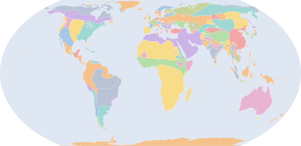
On 1 July 700, IntMap’s historical map draws 181 names across the world. The borders for this date come from Cliopatria, Seshat Global History Databank (by year), then historical-basemaps — each drawn only where the records before it are silent. It also draws 126 outlines whose name the record does not give for this date.
Why this year has a page
The historical-basemaps atlas drew a world sheet for this year.
Names on the map
As the map labels them, largest first by the area of the outline drawn. Areas are of the drawn outline, rounded, and approximate. The record column says which record draws the outline; a Wikidata item is given where the record links one.
| Name | Record | Drawn area (km²) |
|---|---|---|
| Khoiasan | historical-basemaps | 11,200,000 |
| Umayyad Caliphate | Cliopatria · historical-basemaps Q8575586 | 8,650,000 |
| Saharan Nomadic Tribes | historical-basemaps | 8,000,000 |
| Australian aboriginal hunter-gatherers (a description by the source, not a name) | historical-basemaps | 7,600,000 |
| Arctic marine mammal hunters (a description by the source, not a name) | historical-basemaps | 5,910,000 |
| Paleo-Siberian hunter-gatherers (a description by the source, not a name) | historical-basemaps | 5,540,000 |
| West African cereal farmers (a description by the source, not a name) | historical-basemaps | 4,890,000 |
| Savanna hunter-gatherers (a description by the source, not a name) | historical-basemaps | 4,820,000 |
| Subarctic forest hunter-gatherers (a description by the source, not a name) | historical-basemaps | 4,330,000 |
| Amazon hunter-gatherers (a description by the source, not a name) | historical-basemaps | 4,280,000 |
| Tang Dynasty | Cliopatria Q9683 | 4,250,000 |
| Eastern North Amercian hunter-gatherers (a description by the source, not a name) | historical-basemaps | 3,540,000 |
| Plain bison hunters (a description by the source, not a name) | historical-basemaps | 2,850,000 |
| Türgesh | Cliopatria Q1277895 | 2,680,000 |
| Tibetan Empire | Cliopatria Q2431480 | 2,530,000 |
| Desert hunter-gatherers (a description by the source, not a name) | historical-basemaps | 2,350,000 |
| Finno-Ugric taiga hunter-gatherers (a description by the source, not a name) | historical-basemaps | 2,160,000 |
| Tungus | historical-basemaps | 2,000,000 |
| Pampas cultures (a description by the source, not a name) | historical-basemaps | 1,830,000 |
| Göktürks | historical-basemaps | 1,410,000 |
| Samoyèdes | historical-basemaps | 1,350,000 |
| Western Gokturk Khaganate | historical-basemaps | 1,030,000 |
| Turks | Cliopatria | 958,000 |
| Byzantine Empire | Cliopatria Q12544 | 946,000 |
| Kingdom of the Franks | Cliopatria Q146246 | 904,000 |
| Chenla | Cliopatria Q1057118 | 858,000 |
| Chalukya Dynasty | Cliopatria Q1395011 | 807,000 |
| Khazaria | Cliopatria Q173282 | 750,000 |
| Plateau fichers and hunter gatherers (a description by the source, not a name) | historical-basemaps | 722,000 |
| Hindu kingdoms (a description by the source, not a name) | historical-basemaps | 720,000 |
| Kushites | historical-basemaps | 700,000 |
| Saami | historical-basemaps | 617,000 |
| Andean hunter-gatherers (a description by the source, not a name) | historical-basemaps | 582,000 |
| Vazimba | historical-basemaps | 580,000 |
| Visigothic Kingdom | Cliopatria · historical-basemaps Q126936 | 579,000 |
| North American Pacifi foraging, hunting and fishing peoples | historical-basemaps | 533,000 |
| Caribbean hunter-gatherers (a description by the source, not a name) | historical-basemaps | 513,000 |
| Srivijaya | Cliopatria Q234197 | 489,000 |
| Proto-Slavs | historical-basemaps | 465,000 |
| Kanauj | historical-basemaps | 461,000 |
| Merovingian Empire | Cliopatria Q146246 | 452,000 |
| Axum | historical-basemaps | 449,000 |
| Yenisei Kyrgyz | Cliopatria | 422,000 |
| Scandinavian minor kingdoms | Cliopatria | 387,000 |
| Mayan City-States | Cliopatria Q28567 | 380,000 |
| Huari Empire | historical-basemaps | 358,000 |
| Tiahuanaco Empire | historical-basemaps | 355,000 |
| Turk Shahis | Cliopatria | 340,000 |
| Empire of Ghana | historical-basemaps | 335,000 |
| Eastern Roman Empire | historical-basemaps | 307,000 |
All 181 names
| Name | Record | Drawn area (km²) |
|---|---|---|
| Maitraka Dynasty | Cliopatria Q6737189 | 305,000 |
| Thai Kingdoms | historical-basemaps | 298,000 |
| Ethiopian HIghland Peoples | historical-basemaps | 295,000 |
| Kingdom of Sind | historical-basemaps | 294,000 |
| Patagonian shellfish and marine mammal hunters (a description by the source, not a name) | historical-basemaps | 259,000 |
| Palas | historical-basemaps | 252,000 |
| Avar Khaganate | Cliopatria | 238,000 |
| Asuka Japan | Cliopatria | 231,000 |
| Kryvichs | historical-basemaps | 226,000 |
| Tufan Empire | historical-basemaps | 220,000 |
| Makuria | Cliopatria Q829356 | 213,000 |
| Aquitaine | Cliopatria | 205,000 |
| Balts | historical-basemaps | 202,000 |
| First Bulgarian Empire | Cliopatria Q203817 | 173,000 |
| Nan-Zhao | historical-basemaps | 170,000 |
| Alwa | historical-basemaps | 169,000 |
| Ainu | historical-basemaps | 159,000 |
| Unified Silla | Cliopatria Q715257 | 150,000 |
| Shellfish gatherers (a description by the source, not a name) | historical-basemaps | 149,000 |
| Haripuñjaya | Cliopatria Q255931 | 143,000 |
| Bega | historical-basemaps | 131,000 |
| Karluks | historical-basemaps | 129,000 |
| Anglo-Saxon England | Cliopatria Q784963 | 128,000 |
| Lavo Kingdom | Cliopatria Q1332305 | 127,000 |
| Alodia | Cliopatria Q449639 | 124,000 |
| Karkota Dynasty | Cliopatria Q466433 | 118,000 |
| Pyu City-States | Cliopatria Q1627675 | 117,000 |
| Kamarupa Kingdom | Cliopatria Q1194765 | 106,000 |
| Late Pallava Empire | Cliopatria Q466803 | 105,000 |
| minor states under Indian influence (a description by the source, not a name) | historical-basemaps | 99,700 |
| Kingdom of Axum | Cliopatria Q139377 | 97,500 |
| Khadga Dynasty | Cliopatria Q6398879 | 90,800 |
| Blemmyes | historical-basemaps | 88,900 |
| Veracruz civilization (a description by the source, not a name) | historical-basemaps | 88,100 |
| Saxons | Cliopatria · historical-basemaps Q101985 | 85,700 |
| Chámpa | Cliopatria Q216786 | 78,300 |
| Pandya Dynasty | Cliopatria Q844910 | 78,100 |
| Kwarezm | historical-basemaps | 77,600 |
| Hindu states (a description by the source, not a name) | historical-basemaps | 76,900 |
| Bavarians | Cliopatria Q13048507 | 76,200 |
| Anurādhapura | Cliopatria Q5724 | 74,200 |
| Kashmir | Cliopatria Q43100 | 74,000 |
| Swedes | historical-basemaps | 73,300 |
| Polanes | historical-basemaps | 73,200 |
| Makkura | historical-basemaps | 66,700 |
| Dabuyid Dynasty | Cliopatria Q2816439 | 64,800 |
| Chauhans | historical-basemaps | 60,700 |
| Tasmanian hunter-gatherers (a description by the source, not a name) | historical-basemaps | 59,400 |
| Caloosahatchee cultureure | historical-basemaps | 59,100 |
| Severians | historical-basemaps | 58,900 |
| Brythonic Kingdoms | Cliopatria | 57,500 |
| Frisia Kingdom | Cliopatria | 57,000 |
| Monte Alb?n | historical-basemaps | 54,900 |
| Maitraka Kingdom | historical-basemaps | 54,700 |
| Kingdom of Kapisa | historical-basemaps | 52,300 |
| Danube Bulgars | historical-basemaps | 52,200 |
| Chalukyas | historical-basemaps | 48,600 |
| Czechs | historical-basemaps | 48,200 |
| Carantania | Cliopatria Q501754 | 45,400 |
| Kingdom of Mercia | Cliopatria Q105092 | 45,300 |
| Volga Bulgaria | Cliopatria Q185488 | 44,000 |
| Kingdom of Northumbria | Cliopatria Q107299 | 43,900 |
| Bulgars | historical-basemaps | 42,000 |
| Duchy of Thuringia | Cliopatria Q5311389 | 40,400 |
| Mataram | historical-basemaps | 39,100 |
| Teotihuacàn | historical-basemaps | 38,800 |
| Moravians | historical-basemaps | 37,500 |
| Galuh Kingdom | Cliopatria Q5519387 | 36,500 |
| Principality of Iberia | Cliopatria Q199389 | 34,600 |
| Avars | historical-basemaps | 33,900 |
| Magyars | historical-basemaps | 33,300 |
| Kingdom of Kashmir | historical-basemaps | 30,400 |
| Cheras | historical-basemaps | 30,300 |
| Sunda Kingdom | Cliopatria Q1469742 | 27,000 |
| Kingdom of Wessex | Cliopatria Q105313 | 26,400 |
| Pallavas | historical-basemaps | 26,000 |
| Breton Kingdoms | Cliopatria | 24,200 |
| Kingdom of Lazica | Cliopatria Q136884 | 23,400 |
| Yamato | historical-basemaps | 22,800 |
| Magna Frisia | Cliopatria Q87791 | 21,800 |
| Dvaravati | historical-basemaps | 20,900 |
| Nobatia | historical-basemaps | 20,100 |
| Moche | historical-basemaps | 17,500 |
| Frankish Kingdom | historical-basemaps | 17,000 |
| Dál Riata | Cliopatria Q111471 | 15,100 |
| Dumnonia | Cliopatria · historical-basemaps | 14,600 |
| Brythons | Cliopatria | 13,200 |
| Kingdom of East Anglia | Cliopatria Q837998 | 12,600 |
| Strathclyde | Cliopatria | 11,500 |
| Cyprus Condominium | Cliopatria | 11,500 |
| Zapotec Civilization | Cliopatria | 8,580 |
| Maya states (a description by the source, not a name) | historical-basemaps | 8,350 |
| Kingdom of Gwynedd | Cliopatria Q816814 | 7,960 |
| Slavs | historical-basemaps | 7,380 |
| Hejaz | historical-basemaps | 7,210 |
| Cholas | historical-basemaps | 6,860 |
| Kingdom of Powys | Cliopatria Q769782 | 5,760 |
| Teotihuacan | Cliopatria Q172613 | 5,690 |
| Classic Veracruz Culture | Cliopatria Q2379418 | 5,480 |
| Cuacasian Albania | historical-basemaps | 4,420 |
| Huns | historical-basemaps | 3,640 |
| Lombard principalities | historical-basemaps | 2,410 |
| Goths | historical-basemaps | 2,180 |
| Kingdom of Brycheiniog | Cliopatria Q954585 | 1,950 |
| Kingdom of Morgannwg | Cliopatria Q13131807 | 1,620 |
| Cantia | historical-basemaps | 1,510 |
| Lake Vygozero | historical-basemaps | 1,430 |
| Kingdom of Gwent | Cliopatria Q2594661 | 1,390 |
| Mauri | historical-basemaps | 1,150 |
| Alans | historical-basemaps | 1,130 |
| Khazars | historical-basemaps | 1,110 |
| Georgian Kingdom | historical-basemaps | 1,040 |
| Lake Segozerskoye | historical-basemaps | 892 |
| Armenia | historical-basemaps | 683 |
| Sasanian dependencies | historical-basemaps | 665 |
| Warsenis | historical-basemaps | 526 |
| Vasconia | historical-basemaps | 400 |
| Danes | historical-basemaps | 388 |
| Broërec | historical-basemaps | 350 |
| West Getaes | historical-basemaps | 338 |
| Kingdom of Zunbil | historical-basemaps | 278 |
| Pandyas | historical-basemaps | 258 |
| Silla | historical-basemaps | 254 |
| East Getaes | historical-basemaps | 247 |
| Frisians | historical-basemaps | 241 |
| Hainan | historical-basemaps | 217 |
| Champa | historical-basemaps | 186 |
| Neustria | historical-basemaps | 99.7 |
| Guta | historical-basemaps | 72 |
| Aures | historical-basemaps | 71.9 |
| Mazun | historical-basemaps | 64.2 |
What changed since 600
Names counted are those the records date to the year or the day (CShapes, OpenHistoricalMap, Cliopatria). Outlines filled from the nearest historical-basemaps sheet are counted only when both years are years that sheet was drawn for — otherwise the change would be the switch between two sheets, not a change in the world. Names are compared as written, so a polity a record names differently in the two years (Carthaginian Empire, then Carthage) is in both lists.
Now drawn (73)
Umayyad Caliphate, Saharan Nomadic Tribes, Tang Dynasty, Türgesh, Tibetan Empire, Tungus, Samoyèdes, Western Gokturk Khaganate, Turks, Byzantine Empire, Khazaria, Kushites, Srivijaya, Proto-Slavs, Ethiopian HIghland Peoples, Kingdom of Sind, Palas, Kryvichs, Tufan Empire, Aquitaine, Balts, First Bulgarian Empire, Nan-Zhao, Unified Silla, Haripuñjaya, Bega, Karluks, Lavo Kingdom, Khadga Dynasty, Kwarezm, Hindu states, Kashmir, Polanes, Dabuyid Dynasty, Severians, Frisia Kingdom, Maitraka Kingdom, Kingdom of Kapisa, Danube Bulgars, Czechs, Carantania, Volga Bulgaria, Kingdom of Northumbria, Duchy of Thuringia, Moravians, Galuh Kingdom, Principality of Iberia, Magyars, Kingdom of Kashmir, Cheras, Sunda Kingdom, Kingdom of Lazica, Magna Frisia, Strathclyde, Cyprus Condominium, Cholas, Cuacasian Albania, Huns, Goths, Lake Vygozero, Mauri, Alans, Khazars, Georgian Kingdom, Lake Segozerskoye, Armenia, Warsenis, West Getaes, Kingdom of Zunbil, Pandyas, East Getaes, Hainan, Aures
No longer drawn (35)
Sui Dynasty, Western Göktürks, Sasanian Empire, Eastern Göktürks, Tuyuhun, Maukhari Dynasty, Protectorate of the Western Regions, Sui Empire, Goguryeo, Ghassanids, Lakhmid Kingdom, Funan, Shaskanka, Early Lý Dynasty, Kamarupa, Kalabhra Dynasty, Baekje, Tarumanagara, Tuʻi Tonga Empire, Arakan, Koguryo, Kingdom of Deira, Kingdom of Rheged, Kingdom of Bernicia, Kingdom of Sussex, Hwicce, Kingdom of Kent, Kingdom of Essex, Kingdom of Lindsey, Ostrogoths, Tamna, Kingdom of Dunoting, Wihtgar, Paekche, Hunnic Empire
Events dated to 700
The index of dated events holds no event for 700.
Sources and method
Borders and names: Cliopatria v0.2.1 (Seshat Global History Databank, github.com/Seshat-Global-History-Databank/cliopatria) · CC BY 4.0 · adapted by IntMap: simplified, BC years made astronomical, and the ground OpenHistoricalMap (1689–1885, and from 1886 where CShapes is silent) and CShapes (1886–2019) state removed on their own dates + aourednik/historical-basemaps (github.com/aourednik/historical-basemaps) · GPL-3.0 · adapted by IntMap: each sheet before 1886 less the ground OpenHistoricalMap and Cliopatria state at that sheet's year.
Which years have a page is worked out when the site is built, from three rules applied to the records themselves: every year the historical-basemaps atlas drew a world sheet for; every year whose change from the year before (names the dated records begin or stop drawing) is in the top 5% of all such year-to-year changes since the dated records begin, leaving out the years where one record hands over to another; and every year of a geopolitical, war or revolution event in the dated events index, up to the last year the border records cover (2019).
On each year the map is read on 1 July, the instant the app’s own year links open on. Names are the source’s own, translated where the source or IntMap’s name table has a translation. A name is what a record draws there, not a verdict of history.
World map in 700 — the map, with the years it stays the same Historical maps by region Countries On this day