The world in 600
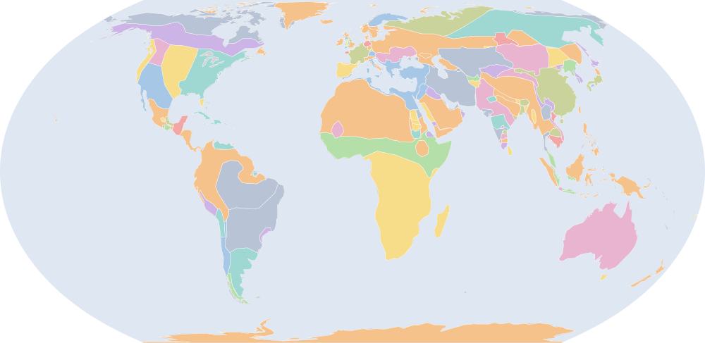
On 1 July 600, IntMap’s historical map draws 143 names across the world. The borders for this date come from Cliopatria, Seshat Global History Databank (by year), then historical-basemaps — each drawn only where the records before it are silent. It also draws 108 outlines whose name the record does not give for this date.
Why this year has a page
The historical-basemaps atlas drew a world sheet for this year.
Names on the map
As the map labels them, largest first by the area of the outline drawn. Areas are of the drawn outline, rounded, and approximate. The record column says which record draws the outline; a Wikidata item is given where the record links one.
| Name | Record | Drawn area (km²) |
|---|---|---|
| Khoiasan | historical-basemaps | 11,200,000 |
| Australian aboriginal hunter-gatherers (a description by the source, not a name) | historical-basemaps | 7,600,000 |
| Paleo-Siberian hunter-gatherers (a description by the source, not a name) | historical-basemaps | 7,050,000 |
| Arctic marine mammal hunters (a description by the source, not a name) | historical-basemaps | 5,910,000 |
| West African cereal farmers (a description by the source, not a name) | historical-basemaps | 5,870,000 |
| Savanna hunter-gatherers (a description by the source, not a name) | historical-basemaps | 4,820,000 |
| Subarctic forest hunter-gatherers (a description by the source, not a name) | historical-basemaps | 4,330,000 |
| Amazon hunter-gatherers (a description by the source, not a name) | historical-basemaps | 4,280,000 |
| Eastern North Amercian hunter-gatherers (a description by the source, not a name) | historical-basemaps | 3,540,000 |
| Finno-Ugric taiga hunter-gatherers (a description by the source, not a name) | historical-basemaps | 3,530,000 |
| Sui Dynasty | Cliopatria Q7405 | 3,320,000 |
| Western Göktürks | Cliopatria Q205466 | 3,110,000 |
| Sasanian Empire | Cliopatria · historical-basemaps Q83891 | 3,110,000 |
| Plain bison hunters (a description by the source, not a name) | historical-basemaps | 2,850,000 |
| Eastern Roman Empire | Cliopatria · historical-basemaps Q12544 | 2,710,000 |
| Eastern Göktürks | Cliopatria Q205466 | 2,640,000 |
| Desert hunter-gatherers (a description by the source, not a name) | historical-basemaps | 2,350,000 |
| Pampas cultures (a description by the source, not a name) | historical-basemaps | 1,830,000 |
| Hindu kingdoms (a description by the source, not a name) | historical-basemaps | 1,670,000 |
| Kingdom of the Franks | Cliopatria Q146246 | 1,360,000 |
| Avar Khaganate | Cliopatria | 957,000 |
| Plateau fichers and hunter gatherers (a description by the source, not a name) | historical-basemaps | 722,000 |
| Göktürks | historical-basemaps | 715,000 |
| Merovingian Empire | Cliopatria Q146246 | 682,000 |
| Saami | historical-basemaps | 617,000 |
| Andean hunter-gatherers (a description by the source, not a name) | historical-basemaps | 582,000 |
| Vazimba | historical-basemaps | 580,000 |
| Visigothic Kingdom | Cliopatria · historical-basemaps Q126936 | 557,000 |
| Tuyuhun | Cliopatria Q1196201 | 554,000 |
| Maukhari Dynasty | Cliopatria Q12448145 | 534,000 |
| Protectorate of the Western Regions | Cliopatria Q911440 | 533,000 |
| North American Pacifi foraging, hunting and fishing peoples | historical-basemaps | 533,000 |
| Caribbean hunter-gatherers (a description by the source, not a name) | historical-basemaps | 513,000 |
| Chalukyas | historical-basemaps | 461,000 |
| Yenisei Kyrgyz | Cliopatria | 422,000 |
| Sui Empire | historical-basemaps | 409,000 |
| Kingdom of Axum | Cliopatria Q139377 | 394,000 |
| Scandinavian minor kingdoms | Cliopatria | 387,000 |
| Mayan City-States | Cliopatria Q28567 | 380,000 |
| Chenla | Cliopatria Q1057118 | 369,000 |
| Goguryeo | Cliopatria Q28370 | 361,000 |
| minor states under Indian influence (a description by the source, not a name) | historical-basemaps | 359,000 |
| Huari Empire | historical-basemaps | 358,000 |
| Tiahuanaco Empire | historical-basemaps | 355,000 |
| Empire of Ghana | historical-basemaps | 335,000 |
| Thai Kingdoms | historical-basemaps | 301,000 |
| Ghassanids | Cliopatria Q733668 | 266,000 |
| Patagonian shellfish and marine mammal hunters (a description by the source, not a name) | historical-basemaps | 259,000 |
| Lakhmid Kingdom | Cliopatria Q943191 | 259,000 |
| Funan | Cliopatria · historical-basemaps Q867782 | 257,000 |
All 143 names
| Name | Record | Drawn area (km²) |
|---|---|---|
| Kanauj | historical-basemaps | 244,000 |
| Asuka Japan | Cliopatria | 231,000 |
| Hejaz | historical-basemaps | 217,000 |
| Chalukya Dynasty | Cliopatria Q1395011 | 204,000 |
| Alwa | historical-basemaps | 169,000 |
| Nobatia | Cliopatria · historical-basemaps Q568523 | 168,000 |
| Ainu | historical-basemaps | 159,000 |
| Maitraka Dynasty | Cliopatria Q6737189 | 151,000 |
| Shellfish gatherers (a description by the source, not a name) | historical-basemaps | 149,000 |
| Turk Shahis | Cliopatria | 138,000 |
| Kamarupa Kingdom | Cliopatria Q1194765 | 134,000 |
| Shaskanka | historical-basemaps | 130,000 |
| Dvaravati | historical-basemaps | 129,000 |
| Karkota Dynasty | Cliopatria Q466433 | 127,000 |
| Alodia | Cliopatria Q449639 | 124,000 |
| Pyu City-States | Cliopatria Q1627675 | 117,000 |
| Chauhans | historical-basemaps | 99,600 |
| Anglo-Saxon England | Cliopatria Q784963 | 93,900 |
| Early Lý Dynasty | Cliopatria Q2441129 | 90,600 |
| Blemmyes | historical-basemaps | 88,900 |
| Veracruz civilization (a description by the source, not a name) | historical-basemaps | 88,100 |
| Silla | Cliopatria · historical-basemaps Q28456 | 87,100 |
| Saxons | Cliopatria · historical-basemaps Q101985 | 86,000 |
| Pallavas | historical-basemaps | 84,100 |
| Brythonic Kingdoms | Cliopatria | 83,000 |
| Bavarians | Cliopatria Q13048507 | 81,000 |
| Pandya Dynasty | Cliopatria Q844910 | 78,100 |
| Chámpa | Cliopatria Q216786 | 77,800 |
| Anurādhapura | Cliopatria Q5724 | 74,200 |
| Kamarupa | historical-basemaps | 74,100 |
| Zapotec Civilization | Cliopatria | 70,000 |
| Makkura | historical-basemaps | 66,400 |
| Makuria | Cliopatria Q829356 | 65,500 |
| Kalabhra Dynasty | Cliopatria Q2572901 | 61,800 |
| Sasanian dependencies | historical-basemaps | 60,100 |
| Tasmanian hunter-gatherers (a description by the source, not a name) | historical-basemaps | 59,400 |
| Caloosahatchee cultureure | historical-basemaps | 59,100 |
| Mazun | historical-basemaps | 54,600 |
| Mataram | historical-basemaps | 52,600 |
| Brythons | Cliopatria | 51,500 |
| Teotihuacàn | historical-basemaps | 38,800 |
| Late Pallava Empire | Cliopatria Q466803 | 38,500 |
| Baekje | Cliopatria Q28428 | 34,800 |
| Tarumanagara | Cliopatria Q2247225 | 33,800 |
| Bulgars | historical-basemaps | 28,900 |
| Breton Kingdoms | Cliopatria | 24,300 |
| Tuʻi Tonga Empire | historical-basemaps | 24,200 |
| Kingdom of Mercia | Cliopatria Q105092 | 23,800 |
| Arakan | historical-basemaps | 23,700 |
| Monte Alb?n | historical-basemaps | 23,100 |
| Yamato | historical-basemaps | 22,800 |
| Koguryo | historical-basemaps | 21,400 |
| Frankish Kingdom | historical-basemaps | 18,500 |
| Moche | historical-basemaps | 17,500 |
| Dál Riata | Cliopatria Q111471 | 16,600 |
| Kingdom of Wessex | Cliopatria Q105313 | 15,900 |
| Kingdom of Deira | Cliopatria Q506008 | 12,900 |
| Kingdom of East Anglia | Cliopatria Q837998 | 12,400 |
| Kingdom of Rheged | Cliopatria Q633573 | 11,600 |
| Kingdom of Bernicia | Cliopatria Q623751 | 10,700 |
| Vasconia | historical-basemaps | 9,110 |
| Frisians | historical-basemaps | 9,080 |
| Maya states (a description by the source, not a name) | historical-basemaps | 8,350 |
| Kingdom of Gwynedd | Cliopatria Q816814 | 7,960 |
| Avars | historical-basemaps | 5,970 |
| Kingdom of Powys | Cliopatria Q769782 | 5,760 |
| Teotihuacan | Cliopatria Q172613 | 5,690 |
| Kingdom of Sussex | Cliopatria Q676184 | 5,640 |
| Classic Veracruz Culture | Cliopatria Q2379418 | 5,480 |
| Axum | historical-basemaps | 5,090 |
| Hwicce | Cliopatria Q733799 | 4,820 |
| Kingdom of Kent | Cliopatria Q328818 | 4,140 |
| Kingdom of Essex | Cliopatria Q110888 | 4,010 |
| Kingdom of Lindsey | Cliopatria Q886986 | 3,920 |
| Ostrogoths | historical-basemaps | 3,810 |
| Swedes | historical-basemaps | 3,070 |
| Lombard principalities | historical-basemaps | 2,570 |
| Cantia | historical-basemaps | 2,260 |
| Tamna | Cliopatria Q28057 | 1,970 |
| Kingdom of Brycheiniog | Cliopatria Q954585 | 1,950 |
| Kingdom of Morgannwg | Cliopatria Q13131807 | 1,620 |
| Kingdom of Dunoting | Cliopatria Q2264840 | 1,510 |
| Kingdom of Gwent | Cliopatria Q2594661 | 1,440 |
| Champa | historical-basemaps | 647 |
| Wihtgar | Cliopatria Q3568009 | 532 |
| Danes | historical-basemaps | 388 |
| Broërec | historical-basemaps | 350 |
| Paekche | historical-basemaps | 205 |
| Slavs | historical-basemaps | 202 |
| Hunnic Empire | Cliopatria | 197 |
| Neustria | historical-basemaps | 94.8 |
| Guta | historical-basemaps | 72 |
| Dumnonia | historical-basemaps | 56.2 |
What changed since 500
Names counted are those the records date to the year or the day (CShapes, OpenHistoricalMap, Cliopatria). Outlines filled from the nearest historical-basemaps sheet are counted only when both years are years that sheet was drawn for — otherwise the change would be the switch between two sheets, not a change in the world. Names are compared as written, so a polity a record names differently in the two years (Carthaginian Empire, then Carthage) is in both lists.
Now drawn (68)
Sui Dynasty, Western Göktürks, Eastern Göktürks, Hindu kingdoms, Avar Khaganate, Göktürks, Vazimba, Maukhari Dynasty, Chalukyas, Yenisei Kyrgyz, Sui Empire, Chenla, minor states under Indian influence, Huari Empire, Tiahuanaco Empire, Thai Kingdoms, Ghassanids, Kanauj, Asuka Japan, Hejaz, Chalukya Dynasty, Alwa, Turk Shahis, Shaskanka, Dvaravati, Karkota Dynasty, Chauhans, Early Lý Dynasty, Bavarians, Pandya Dynasty, Kamarupa, Sasanian dependencies, Mazun, Mataram, Bulgars, Breton Kingdoms, Kingdom of Mercia, Arakan, Monte Alb?n, Frankish Kingdom, Dál Riata, Kingdom of Wessex, Kingdom of Deira, Kingdom of East Anglia, Kingdom of Rheged, Kingdom of Bernicia, Vasconia, Frisians, Kingdom of Gwynedd, Avars, Kingdom of Powys, Classic Veracruz Culture, Hwicce, Kingdom of Essex, Kingdom of Lindsey, Lombard principalities, Cantia, Kingdom of Brycheiniog, Kingdom of Morgannwg, Kingdom of Dunoting, Kingdom of Gwent, Wihtgar, Danes, Broërec, Slavs, Neustria, Guta, Dumnonia
No longer drawn (61)
Rouran Khaganate, White Huns, Southern Qi, Austronesian, Greenland, Gupta Empire, Northern Wei, unclaimed, Hopewell Culture, Vakataka Kingdom, Ostrogothic Kingdom, Himyarite Kingdom, Ruanruan, Laurel complex, Salian Franks, Vandal Kingdom, New Zealand, Point Peninsula, Swift Creek Culture, Kadamba Empire, Lavo, Marksville Culture, Vandals, Kurykans, Burgundian Kingdom, Dorset, Iceland, Kingdom of the Suebi, Caucasian Albania, Fourche Maline Culture, Goodall Focus, Couture Complex, Porter, Copena, Kushan Principalities, Ripuarian Franks, Miller, Nazca, Vishnu-Kundins, Kingdom of Thuringia, Caucasian Iberia, Saugeen Complex, Kadambas, Basks, Western Gangas, Mill Creek Culture, Lazica, Monte Albàn, Vakataka, Poverty point culture, Lombards, Visigoths, Sveves, Turingians, Franks, Toba Wei, Pandyas, Anglo-Saxons, Cheras, Cholas, Armorica
Events dated to 600
The index of dated events holds no event for 600.
Sources and method
Borders and names: Cliopatria v0.2.1 (Seshat Global History Databank, github.com/Seshat-Global-History-Databank/cliopatria) · CC BY 4.0 · adapted by IntMap: simplified, BC years made astronomical, and the ground OpenHistoricalMap (1689–1885, and from 1886 where CShapes is silent) and CShapes (1886–2019) state removed on their own dates + aourednik/historical-basemaps (github.com/aourednik/historical-basemaps) · GPL-3.0 · adapted by IntMap: each sheet before 1886 less the ground OpenHistoricalMap and Cliopatria state at that sheet's year.
Which years have a page is worked out when the site is built, from three rules applied to the records themselves: every year the historical-basemaps atlas drew a world sheet for; every year whose change from the year before (names the dated records begin or stop drawing) is in the top 5% of all such year-to-year changes since the dated records begin, leaving out the years where one record hands over to another; and every year of a geopolitical, war or revolution event in the dated events index, up to the last year the border records cover (2019).
On each year the map is read on 1 July, the instant the app’s own year links open on. Names are the source’s own, translated where the source or IntMap’s name table has a translation. A name is what a record draws there, not a verdict of history.
World map in 600 — the map, with the years it stays the same Historical maps by region Countries On this day