紀元前2,000年の世界
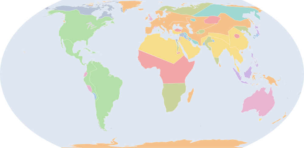
紀元前2,000年7月1日、IntMap の歴史地図は世界に48の名前を描きます。この日付の国境はSeshat Global History Databank の Cliopatria(年単位)、次にhistorical-basemaps(各記録は、前の記録が述べていない土地にだけ描く)によります。 このほか、この日付について記録が名前を与えていない輪郭を99描いています。
この年にページがある理由
historical-basemaps の地図帳がこの年の世界図を描いています。
地図に描かれる名前
地図が書く名前で、描かれる輪郭の面積が大きい順に並べています。面積は描かれた輪郭のもので、丸めた概算です。「記録」はその輪郭を描く記録で、記録が Wikidata の項目を結んでいる場合はそれを示します。
| 名前 | 出典の綴り | 記録 | 描かれる面積(km²) |
|---|---|---|---|
| 古期アメリカ先住民の狩猟採集民 (出典による説明で、名前ではない) | Archaic Amerindian hunter-gatherers | historical-basemaps | 28,800,000 |
| Bantu | historical-basemaps | 12,300,000 | |
| サハラの遊牧民 (出典による説明で、名前ではない) | Saharan pastoral nomads | historical-basemaps | 10,200,000 |
| オーストラリア先住民の狩猟採集民 (出典による説明で、名前ではない) | Australian aboriginal hunter-gatherers | historical-basemaps | 7,600,000 |
| 古シベリア系の狩猟採集民 (出典による説明で、名前ではない) | Paleo-Siberian hunter-gatherers | historical-basemaps | 7,300,000 |
| Khoisan | historical-basemaps | 6,360,000 | |
| オーストロアジア系の稲作文化 (出典による説明で、名前ではない) | Austroasian rice cultures | historical-basemaps | 5,650,000 |
| 北極圏の海獣狩猟民 (出典による説明で、名前ではない) | Arctic marine mammal hunters | historical-basemaps | 5,130,000 |
| メソアメリカの狩猟採集民とトウモロコシ農耕民 (出典による説明で、名前ではない) | Mesoamerican hunter-gatherers and maïze farmers | historical-basemaps | 4,500,000 |
| Andronovo | historical-basemaps | 4,170,000 | |
| フィン・ウゴル系タイガの狩猟採集民 (出典による説明で、名前ではない) | Finno-Ugric taiga hunter-gatherers | historical-basemaps | 4,120,000 |
| Thai | historical-basemaps | 3,810,000 | |
| Semites | historical-basemaps | 2,990,000 | |
| Austronesians | historical-basemaps | 1,510,000 | |
| Tibeto-Burmanese | historical-basemaps | 1,410,000 | |
| アファナシェヴォ文化 | Afanasevo | historical-basemaps | 1,310,000 |
| カタコンベ文化 | Catacomb culture | historical-basemaps | 953,000 |
| 朝鮮民族 | Koreans | historical-basemaps | 800,000 |
| インダス文明 | Indus Valley Civilization | Cliopatria Q42534 | 756,000 |
| エラム | Elam | Cliopatria · historical-basemaps Q128904 | 388,000 |
| アナトリアの諸部族 (出典による説明で、名前ではない) | Anatolian tribes | historical-basemaps | 308,000 |
| Dravidians | historical-basemaps | 306,000 | |
| Norte Chico | historical-basemaps | 294,000 | |
| Oxus | historical-basemaps | 279,000 | |
| Beaker | historical-basemaps | 268,000 | |
| Xia | historical-basemaps | 255,000 | |
| エジプト | Egypt | historical-basemaps | 233,000 |
| ヒッタイト | Hittites | historical-basemaps | 231,000 |
| 都市国家 (出典による説明で、名前ではない) | city-states | historical-basemaps | 228,000 |
| ウル | Ur | historical-basemaps | 197,000 |
| Ainu | historical-basemaps | 186,000 | |
| Jōmon | historical-basemaps | 174,000 | |
| インダス文明 (出典による説明で、名前ではない) | Indus valley civilization | historical-basemaps | 172,000 |
| Valdivia | historical-basemaps | 163,000 | |
| チンチョーロ文化 | Chinchorro culture | historical-basemaps | 151,000 |
| Sintashta | historical-basemaps | 144,000 | |
| エジプト中王国 | Middle Kingdom of Egypt | Cliopatria Q191324 | 94,000 |
| Kerma | historical-basemaps | 85,300 | |
| カナン | Canaan | historical-basemaps | 80,800 |
| ナマズガ=テペ | Namazga | historical-basemaps | 76,200 |
| Hurrian Kingdoms | historical-basemaps | 74,900 | |
| タスマニアの狩猟採集民 (出典による説明で、名前ではない) | Tasmanian hunter-gatherers | historical-basemaps | 59,400 |
| Sumerian City-States | Cliopatria | 54,000 | |
| Únětice | historical-basemaps | 34,600 | |
| 大坌坑文化 (出典による説明で、名前ではない) | Dakapeng culture | historical-basemaps | 32,900 |
| Hunters-gatherers | historical-basemaps | 22,100 | |
| ミノア文明 | Minoan | historical-basemaps | 8,800 |
| Cycladic | historical-basemaps | 4,060 |
紀元前3,000年からの変化
数えるのは、年または日の単位で日付を持つ記録(CShapes・OpenHistoricalMap・Cliopatria)の名前です。最も近い historical-basemaps の図から補った輪郭は、両方の年がその図の描かれた年であるときだけ数えます——そうでなければ、変化は2枚の図の切り替わりであって世界の変化ではないからです。名前は書かれたとおりに比べるので、記録が2つの年で別の名前で書く政体(Carthaginian Empire と Carthage など)は両方の欄に出ます。
新たに描かれる(25)
古期アメリカ先住民の狩猟採集民、サハラの遊牧民、オーストラリア先住民の狩猟採集民、古シベリア系の狩猟採集民、オーストロアジア系の稲作文化、北極圏の海獣狩猟民、メソアメリカの狩猟採集民とトウモロコシ農耕民、Andronovo、フィン・ウゴル系タイガの狩猟採集民、Thai、Tibeto-Burmanese、カタコンベ文化、朝鮮民族、アナトリアの諸部族、Oxus、Beaker、Xia、ヒッタイト、チンチョーロ文化、Sintashta、エジプト中王国、カナン、タスマニアの狩猟採集民、Únětice、大坌坑文化
描かれなくなった(5)
先住民の諸部族、ヤムナ文化、エジプト初期王朝時代、タスマニア・アボリジニ、大坌坑文化
紀元前2,000年の出来事
日付つき出来事の索引には、紀元前2,000年の出来事がありません。
出典と方法
国境と名前:Cliopatria v0.2.1 (Seshat Global History Databank, github.com/Seshat-Global-History-Databank/cliopatria) · CC BY 4.0 · adapted by IntMap: simplified, BC years made astronomical, and the ground OpenHistoricalMap (1689–1885, and from 1886 where CShapes is silent) and CShapes (1886–2019) state removed on their own dates + aourednik/historical-basemaps (github.com/aourednik/historical-basemaps) · GPL-3.0 · adapted by IntMap: each sheet before 1886 less the ground OpenHistoricalMap and Cliopatria state at that sheet's year。
どの年にページがあるかは、サイトのビルド時に記録そのものに3つの規則を当てて決めています:historical-basemaps の地図帳が世界図を描いたすべての年/前年からの変化(日付を持つ記録が描き始める・描かなくなる名前の数)が、日付を持つ記録が始まって以来の年ごとの変化の上位5%に入るすべての年(ある記録から別の記録へ引き継ぐ年は除く)/日付つき出来事の索引にある地政・戦争・革命の出来事のすべての年(国境の記録が覆う最後の年 2019 年まで)。
各年は7月1日で地図を読みます(アプリの年のリンクが開く瞬間)。名前は出典のもので、出典か IntMap の名前表に訳があるときは訳します。名前は記録が描くものであって、何が存在したかの判定ではありません。