1279年の世界
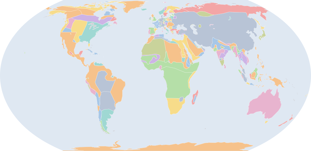
1279年7月1日、IntMap の歴史地図は世界に227の名前を描きます。この日付の国境はSeshat Global History Databank の Cliopatria(年単位)、次にhistorical-basemaps(各記録は、前の記録が述べていない土地にだけ描く)によります。 このほか、この日付について記録が名前を与えていない輪郭を96描いています。
この年にページがある理由
historical-basemaps の地図帳がこの年の世界図を描いています。
地図に描かれる名前
地図が書く名前で、描かれる輪郭の面積が大きい順に並べています。面積は描かれた輪郭のもので、丸めた概算です。「記録」はその輪郭を描く記録で、記録が Wikidata の項目を結んでいる場合はそれを示します。
| 名前 | 出典の綴り | 記録 | 描かれる面積(km²) |
|---|---|---|---|
| モンゴル帝国 | Mongol Empire | Cliopatria Q12557 | 27,400,000 |
| Bantou | historical-basemaps | 8,450,000 | |
| Siberians | historical-basemaps | 7,650,000 | |
| オーストラリア先住民の狩猟採集民 (出典による説明で、名前ではない) | Australian aboriginal hunter-gatherers | historical-basemaps | 7,600,000 |
| Touareg | historical-basemaps | 4,280,000 | |
| 西アフリカの穀作農耕民 (出典による説明で、名前ではない) | West African cereal farmers | historical-basemaps | 4,190,000 |
| 北米東部の狩猟採集民 (出典による説明で、名前ではない) | Eastern North Amercian hunter-gatherers | historical-basemaps | 3,540,000 |
| アマゾンの狩猟採集民 (出典による説明で、名前ではない) | Amazon hunter-gatherers | historical-basemaps | 3,200,000 |
| サバンナの狩猟採集民 (出典による説明で、名前ではない) | Savanna hunter-gatherers | historical-basemaps | 3,040,000 |
| 平原のバイソン狩猟民 (出典による説明で、名前ではない) | Plain bison hunters | historical-basemaps | 2,620,000 |
| 亜寒帯林の狩猟採集民 (出典による説明で、名前ではない) | Subarctic forest hunter-gatherers | historical-basemaps | 2,500,000 |
| Khoiasan | historical-basemaps | 2,490,000 | |
| Thule | historical-basemaps | 2,380,000 | |
| パンパの諸文化 (出典による説明で、名前ではない) | Pampas cultures | historical-basemaps | 1,830,000 |
| マムルーク朝 | Mamluk Sultanate | Cliopatria Q282428 | 1,680,000 |
| 奴隷王朝 | Mamluk Dynasty | Cliopatria Q847420 | 1,350,000 |
| デリー・スルタン朝 | Delhi Sultanate | Cliopatria Q229411 | 1,350,000 |
| Athabaskan | historical-basemaps | 1,200,000 | |
| マリ帝国 | Mali Empire | Cliopatria Q184536 | 977,000 |
| 神聖ローマ帝国 | Holy Roman Empire | Cliopatria · historical-basemaps Q12548 | 975,000 |
| マリ | Mali | historical-basemaps | 798,000 |
| ジョチ・ウルス | Khanate of the Golden Horde | historical-basemaps | 777,000 |
| 高原の漁労民・狩猟採集民 (出典による説明で、名前ではない) | Plateau fichers and hunter gatherers | historical-basemaps | 677,000 |
| フランス王国 | Kingdom of France | Cliopatria Q70972 | 656,000 |
| ヒンドゥー系の小王国群 (出典による説明で、名前ではない) | minor Hindu kingdoms | historical-basemaps | 519,000 |
| クメール王朝 | Khmer Empire | Cliopatria · historical-basemaps Q201705 | 519,000 |
| 神聖ローマ帝国 | Holy Roman Empire Minor States | Cliopatria Q12548 | 517,000 |
| ノヴゴロド | Novgorod | historical-basemaps | 495,000 |
| Dorset | historical-basemaps | 493,000 | |
| Sámi | historical-basemaps | 490,000 | |
| ヤーダヴァ朝 | Yadava Dynasty | Cliopatria Q5790 | 486,000 |
| シュリーヴィジャヤ王国 | Srivijaya | Cliopatria Q234197 | 462,000 |
| アンデスの狩猟採集民 (出典による説明で、名前ではない) | Andean hunter-gatherers | historical-basemaps | 447,000 |
| パガン王朝 | Pagan Kingdom | Cliopatria Q888574 | 441,000 |
| ノルウェー王国 | Old Kingdom of Norway | Cliopatria Q20 | 440,000 |
| 砂漠の狩猟採集民 (出典による説明で、名前ではない) | Desert hunter-gatherers | historical-basemaps | 436,000 |
| North American Pacifi foraging, hunting and fishing peoples | historical-basemaps | 435,000 | |
| マダガスカル | Madagascar | historical-basemaps | 431,000 |
| イングランド王国 | Kingdom of England | Cliopatria Q179876 | 428,000 |
| アンデスの諸国家と首長国 (出典による説明で、名前ではない) | Andean states and chiefdoms | historical-basemaps | 427,000 |
| アイマラ諸王国 | Aymara kingdoms | historical-basemaps | 389,000 |
| ラスール朝 | Rasulid Dynasty | Cliopatria Q2132267 | 380,000 |
| Bornu-Kanem | historical-basemaps | 368,000 | |
| カスティーリャ連合王国 | Crown of Castile | Cliopatria Q217196 | 354,000 |
| ハフス朝 | Hafsid Caliphate | historical-basemaps | 351,000 |
| ハンガリー王国 | Kingdom of Hungary | Cliopatria Q171150 | 348,000 |
| イスラームの都市国家 (出典による説明で、名前ではない) | Islamic city-states | historical-basemaps | 335,000 |
| 鎌倉幕府 | Kamakura Shogunate | Cliopatria Q736839 | 322,000 |
| カリブ海域の狩猟採集民 (出典による説明で、名前ではない) | Caribbean hunter-gatherers | historical-basemaps | 316,000 |
| カーカティーヤ朝 | Kakatiya Dynasty | Cliopatria Q2086556 | 299,000 |
全227の名前
| 名前 | 出典の綴り | 記録 | 描かれる面積(km²) |
|---|---|---|---|
| Sultanate of Delhi | historical-basemaps | 295,000 | |
| 東ローマ帝国 | Byzantine Empire | Cliopatria · historical-basemaps Q12544 | 278,000 |
| バガン | Pagan | historical-basemaps | 275,000 |
| スコータイ王朝 | Sukhothai Kingdom | Cliopatria Q863279 | 273,000 |
| パタゴニアの貝類・海獣狩猟民 (出典による説明で、名前ではない) | Patagonian shellfish and marine mammal hunters | historical-basemaps | 259,000 |
| マオリ | Maori | historical-basemaps | 250,000 |
| Duchies of Poland | Cliopatria | 236,000 | |
| ハフス朝 | Hafsid Dynasty | Cliopatria Q752662 | 226,000 |
| Innu | historical-basemaps | 220,000 | |
| パーンディヤ朝 | Pandya Empire | Cliopatria Q844910 | 219,000 |
| グレート・ジンバブエ遺跡 | Great Zimbabwe | historical-basemaps | 214,000 |
| エチオピア帝国 | Ethiopian Empire | Cliopatria Q207521 | 210,000 |
| 東ガンガ朝 | Eastern Ganga Kingdom | Cliopatria Q250515 | 207,000 |
| デンマーク王国 | Kingdom of Denmark | Cliopatria Q756617 | 202,000 |
| マムルーク朝 | Mamluke Sultanate | historical-basemaps | 197,000 |
| Hadramaut | historical-basemaps | 188,000 | |
| エチオピア | Ethiopia | historical-basemaps | 187,000 |
| イルハン朝 | Ilkhanate | historical-basemaps | 183,000 |
| スウェーデン | Kingdom of Sweden | Cliopatria Q34 | 182,000 |
| スウェーデン | Sweden | historical-basemaps | 180,000 |
| Makkura | historical-basemaps | 180,000 | |
| Srivijaya Empire | historical-basemaps | 178,000 | |
| Taino | historical-basemaps | 172,000 | |
| アルワ王国 | Alwa | historical-basemaps | 164,000 |
| Kingdom of Bohemia | Cliopatria Q42585 | 161,000 | |
| アイヌ | Ainus | historical-basemaps | 159,000 |
| Expansionist Kingdom of Merina | historical-basemaps | 149,000 | |
| マヤ文明 | Later Mayan City-States | Cliopatria Q28567 | 136,000 |
| ノルウェー | Norway | historical-basemaps | 134,000 |
| チベット | Tibet | historical-basemaps | 133,000 |
| ザイヤーン朝 | Zayyanid dynasty | Cliopatria Q307697 | 126,000 |
| アルワ王国 | Alodia | Cliopatria Q449639 | 124,000 |
| チャンパ王国 | Chámpa | Cliopatria Q216786 | 124,000 |
| ドイツ騎士団 | Teutonic Order | Cliopatria Q48189 | 112,000 |
| ベナン | Benin | historical-basemaps | 108,000 |
| ベオスック人 | Beothuk | historical-basemaps | 102,000 |
| 元 | Great Khanate | historical-basemaps | 98,500 |
| ミンスク公国 | Principality of Minsk | Cliopatria Q2662372 | 98,300 |
| 第二次ブルガリア帝国 | Second Bulgarian Empire | Cliopatria Q420759 | 96,300 |
| シチリア島 | Sicily | historical-basemaps | 94,400 |
| Zapotec Empire | historical-basemaps | 92,200 | |
| ポルトガル王国 | Kingdom of Portugal | Cliopatria Q45670 | 91,800 |
| アラゴン連合王国 | Crown of Aragon | Cliopatria Q204920 | 91,600 |
| リトアニア大公国 | Grand Duchy of Lithuania | Cliopatria Q49683 | 90,700 |
| アルバ王国 | Kingdom of Alba | Cliopatria Q1991742 | 85,300 |
| Mahdids | Cliopatria Q1884830 | 84,700 | |
| Aceh | historical-basemaps | 83,200 | |
| チャンデーラ朝 | Chandela Kingdom | Cliopatria Q2039087 | 80,700 |
| ハプスブルク家 | House of Habsburg | Cliopatria Q65968 | 79,400 |
| Chimú Empire | historical-basemaps | 75,000 | |
| Bahrani Dynasty | Cliopatria | 74,300 | |
| シンガサリ王国 | Singhasari | Cliopatria Q2060657 | 74,300 |
| セルビア王国 | Kingdom of Serbia | Cliopatria Q241748 | 73,700 |
| セイロン | Ceylon | Cliopatria | 69,000 |
| Mixtec Empire | historical-basemaps | 68,300 | |
| スンダ王国 | Sunda Kingdom | Cliopatria Q1469742 | 62,700 |
| タスマニアの狩猟採集民 (出典による説明で、名前ではない) | Tasmanian hunter-gatherers | historical-basemaps | 59,400 |
| Caloosahatchee cultureure | historical-basemaps | 59,100 | |
| ホイサラ朝 | Hoysala Kingdom | Cliopatria Q466581 | 57,000 |
| ハリプンチャイ王国 | Haripuñjaya | Cliopatria Q255931 | 55,000 |
| English territory | historical-basemaps | 52,300 | |
| アンジュー=シチリア家 | Capetian House of Anjou | Cliopatria Q939200 | 49,400 |
| Shoa | historical-basemaps | 48,700 | |
| Viking settlements | Cliopatria | 47,200 | |
| 教皇領 | Papal States | Cliopatria · historical-basemaps Q170174 | 46,300 |
| キリキア・アルメニア王国 | Armenian Kingdom of Cilicia | Cliopatria Q335088 | 43,700 |
| ラヴォ王国 | Lavo Kingdom | Cliopatria Q1332305 | 42,900 |
| ブランデンブルク辺境伯 | Margraviate of Brandenburg | Cliopatria Q148499 | 41,300 |
| ブルターニュ公国 | Duchy of Brittany | Cliopatria Q71747 | 37,400 |
| Muscat | historical-basemaps | 36,000 | |
| バイエルン公国 | Duchy of Bavaria | Cliopatria Q47261 | 35,200 |
| チャガタイ・ハン国 | Chagatai Khanate | historical-basemaps | 33,700 |
| グラナダ王国 | Emirate of Granada | Cliopatria Q238445 | 31,400 |
| アンジュー=シチリア家 | House of Anjou-Sicily | Cliopatria Q939200 | 31,300 |
| マゾフシェ公国 | Duchy of Masovia | Cliopatria Q2361927 | 31,200 |
| Duchy of Sandomierz | Cliopatria Q16933165 | 30,600 | |
| フランドル伯領 | County of Flanders | Cliopatria Q157070 | 29,100 |
| アスカーニエン家 | House of Ascania | Cliopatria Q168352 | 28,600 |
| Teutonic Knights | historical-basemaps | 28,500 | |
| ピサ共和国 | Republic of Pisa | Cliopatria Q1365493 | 27,800 |
| Grand Duchy of Kraków | Cliopatria | 26,700 | |
| Sukhothai | historical-basemaps | 26,000 | |
| Duchy of Greater Poland | Cliopatria Q1515009 | 25,700 | |
| シャンパーニュ伯国 | County of Champagne | Cliopatria Q546266 | 25,300 |
| Tuʻi Tonga Empire | historical-basemaps | 24,200 | |
| Guanahatabeyes | historical-basemaps | 21,800 | |
| アルル王国 | Kingdom of Arles | Cliopatria Q3271735 | 20,800 |
| エピロス専制侯国 | Despotate of Epirus | Cliopatria Q187684 | 20,400 |
| カネム・ボルヌ帝国 | Empire of Kanem | Cliopatria Q1139762 | 20,200 |
| マヤの都市国家 (出典による説明で、名前ではない) | Maya city-states | historical-basemaps | 19,800 |
| オーヴェルニュ地域圏 | County of Auvergne | Cliopatria Q1152 | 19,400 |
| バンによるボスニア統治時代 | Banate of Bosnia | Cliopatria Q3627069 | 19,300 |
| シロンスク公国 | Duchy of Silesia | Cliopatria Q568638 | 19,100 |
| ヴィッテルスバッハ家 | House of Wittelsbach | Cliopatria Q131621 | 17,700 |
| ヴェネツィア共和国 | Republic of Venice | Cliopatria Q4948 | 17,700 |
| Kashmir and Ladakh | historical-basemaps | 17,000 | |
| ヒバロ族 | Shuar | historical-basemaps | 16,500 |
| チョーラ朝 (出典による説明で、名前ではない) | Chola state | historical-basemaps | 15,200 |
| サヴォイア伯国 | County of Savoy | Cliopatria Q1232887 | 15,000 |
| トレビゾンド帝国 | Empire of Trebizond | Cliopatria Q178913 | 14,900 |
| ジェノヴァ共和国 | Republic of Genoa | Cliopatria Q174306 | 14,600 |
| グウィネズ王国 | Kingdom of Gwynedd | Cliopatria Q816814 | 14,500 |
| Brythonic Kingdoms | Cliopatria | 14,500 | |
| ポリネシア人 | Polynesians | historical-basemaps | 14,500 |
| テッサリア | Thessaly | Cliopatria Q166919 | 14,400 |
| クダ王国 | Sultanate of Kedah | Cliopatria Q1317579 | 13,300 |
| Bulgar Khanate | historical-basemaps | 13,300 | |
| マヨルカ王国 | Kingdom of Majorca | Cliopatria Q836676 | 12,600 |
| オポーレ公国 | Duchy of Opole | Cliopatria Q661980 | 12,200 |
| County of Brabant | Cliopatria | 11,900 | |
| キプロス王国 | Kingdom of Cyprus | Cliopatria Q213638 | 11,500 |
| フィレンツェ共和国 | Republic of Florence | Cliopatria Q148540 | 10,100 |
| County of Touraine | Cliopatria | 10,100 | |
| ナバラ王国 | Kingdom of Navarre | Cliopatria Q200262 | 10,000 |
| Abdelouadides | historical-basemaps | 9,560 | |
| ギュイエンヌ(アキテーヌ)公領 | Duchy of Aquitaine | Cliopatria Q7703611 | 9,560 |
| ドーフィネ | Dauphiné | Cliopatria Q151999 | 9,260 |
| グアンチェ族 | Guanches | historical-basemaps | 9,080 |
| アクイレイア大司教座 | Patriarchate of Aquileia | Cliopatria Q836894 | 8,990 |
| サムドラ・パサイ王国 | Samudera Pasai Sultanate | Cliopatria Q3284315 | 8,900 |
| Puebloans - Aztec Regional System | Cliopatria | 8,740 | |
| County of Périgord | Cliopatria Q1947408 | 8,570 | |
| ホラント伯国 | County of Holland | Cliopatria Q762943 | 8,470 |
| アテネ公国 | Duchy of Athens | Cliopatria Q334714 | 8,360 |
| ブロワ伯国 | County of Blôis | Cliopatria Q19336869 | 8,060 |
| アルトワ伯国 | County of Artois | Cliopatria Q778266 | 7,560 |
| Seljuk Caliphate | historical-basemaps | 7,180 | |
| フランス | France | historical-basemaps | 7,070 |
| County of Armagnac | Cliopatria | 6,970 | |
| ヴェネツィア | Venice | historical-basemaps | 6,970 |
| チムー王国 | Chimu Empire | Cliopatria Q581741 | 6,930 |
| ルクセンブルク家 | House of Luxembourg | Cliopatria Q122293 | 5,790 |
| Aragón | historical-basemaps | 5,360 | |
| ダンバデニヤ王国 | Kingdom of Dambadeniya | Cliopatria Q3136869 | 5,240 |
| リャザン | Ryazan | historical-basemaps | 5,140 |
| フォワ伯領 | County of Foix | Cliopatria Q1481436 | 4,580 |
| ハンガリー | Hungary | historical-basemaps | 4,480 |
| Giudicato of Arborea | Cliopatria Q1241847 | 3,880 | |
| セルビア | Serbia | historical-basemaps | 3,800 |
| Arawaks | historical-basemaps | 3,440 | |
| Castile | historical-basemaps | 3,390 | |
| グウォグフ公国 | Duchy of Głogów | Cliopatria Q684501 | 2,940 |
| Texcoco | Cliopatria | 2,640 | |
| レグニツァ公国 | Duchy of Legnica | Cliopatria Q570740 | 2,360 |
| Granada | historical-basemaps | 2,210 | |
| デンマーク | Denmark | historical-basemaps | 2,180 |
| エルサレム王国 | Kingdom of Jerusalem | Cliopatria Q55502 | 2,110 |
| コンタ・ヴェネッサン | Comtat Venaissin | Cliopatria Q1122980 | 2,100 |
| Đại Việt | historical-basemaps | 1,470 | |
| Merinides | historical-basemaps | 1,270 | |
| パーンディヤ朝 (出典による説明で、名前ではない) | Pandya state | historical-basemaps | 1,270 |
| ナクソス公国 | Duchy of the Archipelago | Cliopatria Q777981 | 1,240 |
| ヤヴォル公国 | Duchy of Jawor | Cliopatria Q561204 | 1,090 |
| Shogun Japan (Kamakura) | historical-basemaps | 1,050 | |
| Trebizond | historical-basemaps | 1,010 | |
| ナマヤン王国 | Namayan | Cliopatria Q4401026 | 878 |
| Orissa | historical-basemaps | 868 | |
| Corsica | historical-basemaps | 859 | |
| アンプリアス郡 | County of Ampuria | Cliopatria Q1541699 | 832 |
| スコットランド | Scotland | historical-basemaps | 720 |
| カトマンズ | Kathmandu | Cliopatria Q3037 | 664 |
| シチリア王国 | Kingdom of Sicily | Cliopatria Q188586 | 565 |
| Navarre | historical-basemaps | 529 | |
| トリポリ伯国 | County of Tripoli | Cliopatria Q272033 | 455 |
| ジョージア | Georgia | historical-basemaps | 387 |
| ウルジェイ郡 | County of Urgell | Cliopatria Q1514510 | 379 |
| Luva | historical-basemaps | 302 | |
| スティリア公 | Duchy of Styria | Cliopatria Q580447 | 276 |
| イエメン | Yemen | historical-basemaps | 238 |
| Hainan | historical-basemaps | 217 | |
| リトアニア | Lithuania | historical-basemaps | 195 |
| ポルトガル | Portugal | historical-basemaps | 184 |
| オランジュ公国 | Principality of Orange | Cliopatria Q2281221 | 140 |
| キプロス | Cyprus | historical-basemaps | 45.4 |
| Britany | historical-basemaps | 31.4 | |
| ポーランド | Poland | historical-basemaps | 28.5 |
| Sardinia | historical-basemaps | 27.5 |
1260年からの変化
数えるのは、年または日の単位で日付を持つ記録(CShapes・OpenHistoricalMap・Cliopatria)の名前です。最も近い historical-basemaps の図から補った輪郭は、両方の年がその図の描かれた年であるときだけ数えます——そうでなければ、変化は2枚の図の切り替わりであって世界の変化ではないからです。名前は書かれたとおりに比べるので、記録が2つの年で別の名前で書く政体(Carthaginian Empire と Carthage など)は両方の欄に出ます。
新たに描かれる(11)
東ローマ帝国、エチオピア帝国、アンジュー=シチリア家、Grand Duchy of Kraków、テッサリア、マヨルカ王国、サムドラ・パサイ王国、レグニツァ公国、コンタ・ヴェネッサン、ヤヴォル公国、ウルジェイ郡
描かれなくなった(14)
宋、ムワッヒド朝、ニカイア帝国、マクリア王国、アイスランド自治州、ホーエンシュタウフェン朝、Norse Greenland、アカイア公国、ザグウェ朝、ヌベール伯国、島嶼部王国、アンティオキア公国、ラテン帝国、耽羅
1279年の出来事
日付つき出来事の索引には、1279年の出来事がありません。
出典と方法
国境と名前:Cliopatria v0.2.1 (Seshat Global History Databank, github.com/Seshat-Global-History-Databank/cliopatria) · CC BY 4.0 · adapted by IntMap: simplified, BC years made astronomical, and the ground OpenHistoricalMap (1689–1885, and from 1886 where CShapes is silent) and CShapes (1886–2019) state removed on their own dates + aourednik/historical-basemaps (github.com/aourednik/historical-basemaps) · GPL-3.0 · adapted by IntMap: each sheet before 1886 less the ground OpenHistoricalMap and Cliopatria state at that sheet's year。
どの年にページがあるかは、サイトのビルド時に記録そのものに3つの規則を当てて決めています:historical-basemaps の地図帳が世界図を描いたすべての年/前年からの変化(日付を持つ記録が描き始める・描かなくなる名前の数)が、日付を持つ記録が始まって以来の年ごとの変化の上位5%に入るすべての年(ある記録から別の記録へ引き継ぐ年は除く)/日付つき出来事の索引にある地政・戦争・革命の出来事のすべての年(国境の記録が覆う最後の年 2019 年まで)。
各年は7月1日で地図を読みます(アプリの年のリンクが開く瞬間)。名前は出典のもので、出典か IntMap の名前表に訳があるときは訳します。名前は記録が描くものであって、何が存在したかの判定ではありません。