1236年の世界
1236年7月1日、IntMap の歴史地図は世界に247の名前を描きます。この日付の国境はSeshat Global History Databank の Cliopatria(年単位)、次にhistorical-basemaps(各記録は、前の記録が述べていない土地にだけ描く)によります。 このほか、この日付について記録が名前を与えていない輪郭を117描いています。
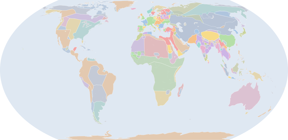
この年にページがある理由
年または日の単位で日付を持つ記録の、前年からの変化が最も大きい年の一つです:1235年7月1日から1236年7月1日までに36の名前が描かれ始めるか、描かれなくなります。
地図に描かれる名前
地図が書く名前で、描かれる輪郭の面積が大きい順に並べています。面積は描かれた輪郭のもので、丸めた概算です。「記録」はその輪郭を描く記録で、記録が Wikidata の項目を結んでいる場合はそれを示します。
| 名前 | 出典の綴り | 記録 | 描かれる面積(km²) |
|---|---|---|---|
| モンゴル帝国 | Mongol Empire | Cliopatria · historical-basemaps Q12557 | 23,000,000 |
| Bantou | historical-basemaps | 8,460,000 | |
| オーストラリア先住民の狩猟採集民 (出典による説明で、名前ではない) | Australian aboriginal hunter-gatherers | historical-basemaps | 7,600,000 |
| Tuareg Nomadic Tribes | historical-basemaps | 5,780,000 | |
| 古シベリア系の狩猟採集民 (出典による説明で、名前ではない) | Paleo-Siberian hunter-gatherers | historical-basemaps | 5,540,000 |
| 西アフリカの穀作農耕民 (出典による説明で、名前ではない) | West African cereal farmers | historical-basemaps | 4,920,000 |
| 北極圏の海獣狩猟民 (出典による説明で、名前ではない) | Arctic marine mammal hunters | historical-basemaps | 4,130,000 |
| 北米東部の狩猟採集民 (出典による説明で、名前ではない) | Eastern North Amercian hunter-gatherers | historical-basemaps | 3,540,000 |
| アマゾンの狩猟採集民 (出典による説明で、名前ではない) | Amazon hunter-gatherers | historical-basemaps | 3,200,000 |
| フィン・ウゴル系タイガの狩猟採集民 (出典による説明で、名前ではない) | Finno-Ugric taiga hunter-gatherers | historical-basemaps | 3,090,000 |
| サバンナの狩猟採集民 (出典による説明で、名前ではない) | Savanna hunter-gatherers | historical-basemaps | 3,040,000 |
| 平原のバイソン狩猟民 (出典による説明で、名前ではない) | Plain bison hunters | historical-basemaps | 2,620,000 |
| 亜寒帯林の狩猟採集民 (出典による説明で、名前ではない) | Subarctic forest hunter-gatherers | historical-basemaps | 2,500,000 |
| Khoiasan | historical-basemaps | 2,490,000 | |
| Berber Tribes | historical-basemaps | 2,440,000 | |
| 宋 | Southern Song | Cliopatria Q7462 | 2,060,000 |
| Dorset | historical-basemaps | 1,890,000 | |
| Tibetans | Cliopatria | 1,860,000 | |
| パンパの諸文化 (出典による説明で、名前ではない) | Pampas cultures | historical-basemaps | 1,830,000 |
| 神聖ローマ帝国 | Holy Roman Empire | Cliopatria · historical-basemaps Q12548 | 1,790,000 |
| アイユーブ朝 | Ayyubid Sultanate | Cliopatria Q180114 | 1,520,000 |
| 奴隷王朝 | Mamluk Dynasty | Cliopatria Q847420 | 1,290,000 |
| デリー・スルタン朝 | Delhi Sultanate | Cliopatria Q229411 | 1,290,000 |
| Athabaskan | historical-basemaps | 1,200,000 | |
| Tungusic Tribes | historical-basemaps | 987,000 | |
| マリ帝国 | Mali Empire | Cliopatria Q184536 | 977,000 |
| Kara Khitai Khaganate | historical-basemaps | 849,000 | |
| クメール王朝 | Khmer Empire | Cliopatria · historical-basemaps Q201705 | 834,000 |
| Ifat | historical-basemaps | 822,000 | |
| マレー人 | Malays | historical-basemaps | 786,000 |
| Papuans | historical-basemaps | 761,000 | |
| 高原の漁労民・狩猟採集民 (出典による説明で、名前ではない) | Plateau fichers and hunter gatherers | historical-basemaps | 677,000 |
| フランス王国 | Kingdom of France | Cliopatria Q70972 | 599,000 |
| Thule | historical-basemaps | 568,000 | |
| ムワッヒド朝 | Almohad Caliphate | Cliopatria · historical-basemaps Q199688 | 529,000 |
| ノヴゴロド公国 | Novgorod Republic | Cliopatria Q151536 | 509,000 |
| Sámi | historical-basemaps | 490,000 | |
| チベット | Tibet | historical-basemaps | 478,000 |
| シュリーヴィジャヤ王国 | Srivijaya | Cliopatria Q234197 | 462,000 |
| ヤーダヴァ朝 | Yadava Dynasty | Cliopatria Q5790 | 448,000 |
| アンデスの狩猟採集民 (出典による説明で、名前ではない) | Andean hunter-gatherers | historical-basemaps | 447,000 |
| イングランド王国 | Kingdom of England | Cliopatria Q179876 | 444,000 |
| パガン王朝 | Pagan Kingdom | Cliopatria Q888574 | 441,000 |
| 砂漠の狩猟採集民 (出典による説明で、名前ではない) | Desert hunter-gatherers | historical-basemaps | 436,000 |
| North American Pacifi foraging, hunting and fishing peoples | historical-basemaps | 435,000 | |
| マダガスカル | Madagascar | historical-basemaps | 431,000 |
| ワリ帝国 | Huari Empire | historical-basemaps | 426,000 |
| ラスール朝 | Rasulid Dynasty | Cliopatria Q2132267 | 380,000 |
| メソアメリカの都市国家と首長国 (出典による説明で、名前ではない) | Mesoamerican city-states and chiefdoms | historical-basemaps | 379,000 |
| Cuman Khanates | historical-basemaps | 375,000 |
全247の名前
| 名前 | 出典の綴り | 記録 | 描かれる面積(km²) |
|---|---|---|---|
| 大理国 | Kingdom of Dali | Cliopatria Q26472 | 360,000 |
| Makkura | historical-basemaps | 352,000 | |
| ルーム・セルジューク朝 | Sultanate of Rum | Cliopatria Q975405 | 347,000 |
| イスラームの都市国家 (出典による説明で、名前ではない) | Islamic city-states | historical-basemaps | 335,000 |
| ハンガリー王国 | Kingdom of Hungary | Cliopatria Q171150 | 334,000 |
| ハールィチ・ヴォルィーニ大公国 | Halych-Volhynia occupation | Cliopatria Q239502 | 333,000 |
| ラージプート | Rajput Kingdoms | historical-basemaps | 328,000 |
| 鎌倉幕府 | Kamakura Shogunate | Cliopatria Q736839 | 322,000 |
| カリブ海域の狩猟採集民 (出典による説明で、名前ではない) | Caribbean hunter-gatherers | historical-basemaps | 316,000 |
| ノルウェー王国 | Old Kingdom of Norway | Cliopatria Q20 | 312,000 |
| 第二次ブルガリア帝国 | Second Bulgarian Empire | Cliopatria Q420759 | 312,000 |
| カスティーリャ連合王国 | Crown of Castile | Cliopatria Q217196 | 311,000 |
| アルワ王国 | Alwa | historical-basemaps | 307,000 |
| Sultanate of Delhi | historical-basemaps | 277,000 | |
| パタゴニアの貝類・海獣狩猟民 (出典による説明で、名前ではない) | Patagonian shellfish and marine mammal hunters | historical-basemaps | 259,000 |
| カーカティーヤ朝 | Kakatiya Dynasty | Cliopatria Q2086556 | 256,000 |
| Song Empire | historical-basemaps | 255,000 | |
| ウラジーミル・スーズダリ大公国 | Principality of Rostov-Suzdal | Cliopatria Q83546 | 249,000 |
| チャウルキヤ朝 | Chaulukya Dynasty | Cliopatria Q18211496 | 235,000 |
| Lohara Dynasty | Cliopatria Q1315339 | 227,000 | |
| ハフス朝 | Hafsid Dynasty | Cliopatria Q752662 | 226,000 |
| Duchies of Poland | Cliopatria | 220,000 | |
| グレート・ジンバブエ遺跡 | Great Zimbabwe | historical-basemaps | 214,000 |
| マクリア王国 | Makuria | Cliopatria Q829356 | 213,000 |
| Kanem | historical-basemaps | 208,000 | |
| デンマーク王国 | Kingdom of Denmark | Cliopatria Q756617 | 203,000 |
| Hadramaut | historical-basemaps | 202,000 | |
| チェルニーヒウ公国 | Principality of Chernigov | Cliopatria Q1322662 | 200,000 |
| ハールィチ・ヴォルィーニ大公国 | Principality of Galicia-Volhynia | Cliopatria · historical-basemaps Q239502 | 189,000 |
| Taino | historical-basemaps | 172,000 | |
| アッバース朝 | Abbasid Caliphate | Cliopatria Q12536 | 168,000 |
| ヴォルガ・ブルガール | Volga Bulgars | historical-basemaps | 167,000 |
| Srivijaya Empire | historical-basemaps | 163,000 | |
| Ainu | historical-basemaps | 159,000 | |
| 東ガンガ朝 | Eastern Ganga Kingdom | Cliopatria Q250515 | 151,000 |
| Innu | historical-basemaps | 150,000 | |
| Expansionist Kingdom of Merina | historical-basemaps | 149,000 | |
| バガン | Bagan | historical-basemaps | 149,000 |
| 高麗 | Goryeo | Cliopatria · historical-basemaps Q28208 | 147,000 |
| スウェーデン | Kingdom of Sweden | Cliopatria Q34 | 146,000 |
| Kingdom of Bohemia | Cliopatria Q42585 | 141,000 | |
| マヤ文明 | Later Mayan City-States | Cliopatria Q28567 | 136,000 |
| ヒンドゥー・仏教系の小国家群 (出典による説明で、名前ではない) | minor Hindu and Buddhist states | historical-basemaps | 129,000 |
| ザイヤーン朝 | Zayyanid dynasty | Cliopatria Q307697 | 126,000 |
| アルワ王国 | Alodia | Cliopatria Q449639 | 124,000 |
| チャンパ王国 | Chámpa | Cliopatria Q216786 | 124,000 |
| シロンスク公国 | Duchy of Silesia | Cliopatria Q568638 | 120,000 |
| マリ | Mali | historical-basemaps | 118,000 |
| East Java | historical-basemaps | 118,000 | |
| スモレンスク公国 | Principality of Smolensk | Cliopatria Q1483495 | 116,000 |
| イバード派 | Ibadites | historical-basemaps | 115,000 |
| ホイサラ朝 | Hoysala Kingdom | Cliopatria Q466581 | 112,000 |
| アイスランド自治州 | Icelandic Commonwealth | Cliopatria Q62389 | 112,000 |
| ザンギー朝 | Zengid dynasty | Cliopatria Q189545 | 109,000 |
| ベオスック人 | Beothuk | historical-basemaps | 102,000 |
| ガーナ | Ghana | historical-basemaps | 96,900 |
| スウェーデン | Sweden | historical-basemaps | 95,100 |
| Chola Empire | Cliopatria Q6806806 | 95,000 | |
| ペレヤースラウ公国 | Principality of Pereyaslavl | Cliopatria Q1261908 | 94,700 |
| アラゴン連合王国 | Crown of Aragon | Cliopatria Q204920 | 94,600 |
| ニカイア帝国 | Nicaean Empire | Cliopatria Q181254 | 93,300 |
| シチリア王国 | Kingdom of Sicily | Cliopatria Q188586 | 91,900 |
| Xixia | historical-basemaps | 87,900 | |
| Mahdids | Cliopatria Q1884830 | 84,500 | |
| トルテカ帝国 | Toltec Empire | historical-basemaps | 83,400 |
| チャンデーラ朝 | Chandela Kingdom | Cliopatria Q2039087 | 80,700 |
| パーンディヤ朝 | Pandya Empire | Cliopatria Q844910 | 78,500 |
| キエフ公国 | Principality of Kiev | Cliopatria Q1483430 | 78,100 |
| ウラジーミル・スーズダリ大公国 | Principality of Vladimir-Suzdal | historical-basemaps | 78,100 |
| ブータン | Bhutan | historical-basemaps | 76,300 |
| シンガサリ王国 | Singhasari | Cliopatria Q2060657 | 74,300 |
| ポロンナルワ王国 | Kingdom of Polonnaruwa | Cliopatria Q3167772 | 73,900 |
| ネパール | Nepal | historical-basemaps | 73,200 |
| ポルトガル王国 | Kingdom of Portugal | Cliopatria Q45670 | 69,600 |
| トゥーロフ公国 | Principality of Turov and Pinsk | Cliopatria Q671362 | 69,100 |
| リヴォニア帯剣騎士団 | Livonian Brothers of the Sword | Cliopatria Q157605 | 67,800 |
| リャザン公国 | Principality of Ryazan | Cliopatria Q269109 | 65,300 |
| アルバ王国 | Kingdom of Alba | Cliopatria Q1991742 | 64,800 |
| スンダ王国 | Sunda Kingdom | Cliopatria Q1469742 | 62,700 |
| グルジア王国 | Kingdom of Georgia | Cliopatria Q154667 | 61,000 |
| リトアニア大公国 | Grand Duchy of Lithuania | Cliopatria Q49683 | 60,200 |
| キリキア・アルメニア王国 | Armenian Kingdom of Cilicia | Cliopatria Q335088 | 59,600 |
| タスマニアの狩猟採集民 (出典による説明で、名前ではない) | Tasmanian hunter-gatherers | historical-basemaps | 59,400 |
| Caloosahatchee cultureure | historical-basemaps | 59,100 | |
| ハリプンチャイ王国 | Haripuñjaya | Cliopatria Q255931 | 55,000 |
| ハリプンチャイ王国 | Harapunchai | historical-basemaps | 52,900 |
| ケルト諸王国 (出典による説明で、名前ではない) | Celtic kingdoms | historical-basemaps | 52,600 |
| ミンスク公国 | Principality of Minsk | Cliopatria Q2662372 | 51,500 |
| セルビア王国 | Kingdom of Serbia | Cliopatria Q241748 | 49,600 |
| トゥールーズ伯 | County of Toulouse | Cliopatria Q1334322 | 48,100 |
| Viking settlements | Cliopatria | 47,300 | |
| ラテン帝国 | Latin Empire | Cliopatria Q178897 | 47,200 |
| Takrur | historical-basemaps | 45,600 | |
| ノルウェー | Norway | historical-basemaps | 44,700 |
| セイロン | Ceylon | Cliopatria | 41,700 |
| エピロス専制侯国 | Despotate of Epirus | Cliopatria Q187684 | 41,200 |
| ブルターニュ公国 | Duchy of Brittany | Cliopatria Q71747 | 37,400 |
| チョーラ朝 (出典による説明で、名前ではない) | Chola state | historical-basemaps | 37,200 |
| Taiwanese Tribes | historical-basemaps | 36,300 | |
| 東ローマ帝国 | Byzantine Empire | historical-basemaps | 34,400 |
| ポラツク | Principality of Polotsky | Cliopatria Q200797 | 34,300 |
| マゾフシェ公国 | Duchy of Masovia | Cliopatria Q2361927 | 31,700 |
| Duchy of Sandomierz | Cliopatria Q16933165 | 30,500 | |
| Taifas of Iberia | Cliopatria | 29,900 | |
| バンによるボスニア統治時代 | Banate of Bosnia | Cliopatria Q3627069 | 29,100 |
| ピサ共和国 | Republic of Pisa | Cliopatria Q1365493 | 27,800 |
| Norse Greenland | Cliopatria | 26,000 | |
| シャンパーニュ伯国 | County of Champagne | Cliopatria Q546266 | 25,100 |
| Tuʻi Tonga Empire | historical-basemaps | 24,200 | |
| Chimú Empire | historical-basemaps | 23,700 | |
| ポワトゥー伯国 | County of Poitou | Cliopatria Q2991374 | 23,600 |
| ヴェネツィア共和国 | Republic of Venice | Cliopatria Q4948 | 22,500 |
| オポーレ公国 | Duchy of Opole | Cliopatria Q661980 | 22,400 |
| テッサロニキ帝国 | Empire of Thessalonica | Cliopatria Q623151 | 22,000 |
| Guanahatabeyes | historical-basemaps | 21,800 | |
| アルル王国 | Kingdom of Arles | Cliopatria Q3271735 | 20,900 |
| カネム・ボルヌ帝国 | Empire of Kanem | Cliopatria Q1139762 | 20,200 |
| マヤの都市国家 (出典による説明で、名前ではない) | Maya city-states | historical-basemaps | 20,200 |
| ドルツク公国 | Principality of Drutsk | Cliopatria Q2596884 | 19,900 |
| アカイア公国 | Principality of Achaea | Cliopatria Q332005 | 19,400 |
| オーヴェルニュ地域圏 | County of Auvergne | Cliopatria Q1152 | 18,900 |
| 教皇領 | Papal States | Cliopatria · historical-basemaps Q170174 | 16,900 |
| Duchy of Greater Poland | Cliopatria Q1515009 | 15,500 | |
| トレビゾンド帝国 | Empire of Trebizond | Cliopatria Q178913 | 15,200 |
| ザグウェ朝 | Zagwe dynasty | Cliopatria Q140446 | 14,500 |
| グウィネズ王国 | Kingdom of Gwynedd | Cliopatria Q816814 | 14,500 |
| Brythonic Kingdoms | Cliopatria | 14,500 | |
| ポリネシア人 | Polynesians | historical-basemaps | 14,500 |
| クダ王国 | Sultanate of Kedah | Cliopatria Q1317579 | 13,300 |
| モン族の国家 (出典による説明で、名前ではない) | Mon state | historical-basemaps | 13,200 |
| ヌベール伯国 | County of Nevers | Cliopatria Q2070440 | 12,300 |
| County of Périgord | Cliopatria Q1947408 | 12,100 | |
| ポーランド | Poland | historical-basemaps | 11,600 |
| キプロス王国 | Kingdom of Cyprus | Cliopatria Q213638 | 11,500 |
| ピュー国家 (出典による説明で、名前ではない) | Pyu state | historical-basemaps | 11,100 |
| County of Touraine | Cliopatria | 10,200 | |
| ナバラ王国 | Kingdom of Navarre | Cliopatria Q200262 | 10,000 |
| ギュイエンヌ(アキテーヌ)公領 | Duchy of Aquitaine | Cliopatria Q7703611 | 9,560 |
| フランドル伯領 | County of Flanders | Cliopatria Q157070 | 9,200 |
| グアンチェ族 | Guanches | historical-basemaps | 9,080 |
| アテネ公国 | Duchy of Athens | Cliopatria Q334714 | 8,950 |
| エルサレム王国 | Kingdom of Jerusalem | Cliopatria Q55502 | 8,920 |
| Puebloans - Aztec Regional System | Cliopatria | 8,740 | |
| Giudicato of Logudoro | Cliopatria Q1761381 | 8,260 | |
| ブロワ伯国 | County of Blôis | Cliopatria Q19336869 | 7,970 |
| ムルシア王国 | Taifa of Murcia | Cliopatria Q921067 | 7,840 |
| バランシア王国 | Taifa of Valencia | Cliopatria Q676811 | 7,750 |
| デニア王国 | Taifa of Dénia | Cliopatria Q252323 | 7,220 |
| County of Armagnac | Cliopatria | 7,070 | |
| チムー王国 | Chimu Empire | Cliopatria Q581741 | 6,930 |
| 島嶼部王国 | Kingdom of Mann | Cliopatria Q459188 | 5,980 |
| アンジュー帝国 | Angevin Empire | historical-basemaps | 5,880 |
| ジェノヴァ共和国 | Republic of Genoa | Cliopatria Q174306 | 5,870 |
| Comté de Toulouse | historical-basemaps | 5,770 | |
| アンティオキア公国 | Principality of Antioch | Cliopatria Q235030 | 5,460 |
| ダンバデニヤ王国 | Kingdom of Dambadeniya | Cliopatria Q3136869 | 5,240 |
| Bulgar Khanate | historical-basemaps | 4,850 | |
| Muscat | historical-basemaps | 4,700 | |
| フォワ伯領 | County of Foix | Cliopatria Q1481436 | 4,580 |
| ドイツ騎士団 | Teutonic Order | Cliopatria Q48189 | 3,960 |
| Giudicato of Arborea | Cliopatria Q1241847 | 3,880 | |
| クロアチア | Croatia | historical-basemaps | 3,580 |
| Arawaks | historical-basemaps | 3,440 | |
| トリポリ伯国 | County of Tripoli | Cliopatria Q272033 | 3,180 |
| Texcoco | Cliopatria | 2,640 | |
| León | historical-basemaps | 2,370 | |
| ロドス島 | Domain of Rhodes | Cliopatria Q43048 | 2,200 |
| 舜天王統 | Shunten Dynasty | Cliopatria Q6151113 | 2,200 |
| 耽羅 | Tamna | Cliopatria Q28057 | 1,970 |
| ヴェネツィア | Venice | historical-basemaps | 1,920 |
| Đại Việt | historical-basemaps | 1,780 | |
| Taifa of Niebla | Cliopatria Q2668600 | 1,550 | |
| Aragón | historical-basemaps | 1,460 | |
| ナクソス公国 | Duchy of the Archipelago | Cliopatria Q777981 | 1,240 |
| キエフ大公国 | Kievan Rus' | Cliopatria Q1108445 | 1,180 |
| Imperial Japan (Fujiwara) | historical-basemaps | 1,050 | |
| Burgandy | historical-basemaps | 979 | |
| デンマーク | Denmark | historical-basemaps | 885 |
| ナマヤン王国 | Namayan | Cliopatria Q4401026 | 878 |
| アンプリアス郡 | County of Ampuria | Cliopatria Q1541699 | 808 |
| カトマンズ | Kathmandu | Cliopatria Q3037 | 664 |
| Castilla | historical-basemaps | 573 | |
| ジョージア | Georgia | historical-basemaps | 548 |
| Taifa of Córdoba | Cliopatria | 418 | |
| Kwarizm-Shah | historical-basemaps | 258 | |
| スコットランド | Scotland | historical-basemaps | 258 |
| Navarre | historical-basemaps | 242 | |
| イエメン | Yemen | historical-basemaps | 238 |
| Hainan | historical-basemaps | 217 | |
| Champa City States | historical-basemaps | 189 | |
| Sardinia | historical-basemaps | 88.7 | |
| Corsica | historical-basemaps | 50.1 | |
| キプロス | Cyprus | historical-basemaps | 45.4 |
| Britany | historical-basemaps | 31.4 | |
| Other Rus Principalities | historical-basemaps | 15.5 | |
| アルメニア | Armenia | historical-basemaps | 6.79 |
| ポルトガル | Portugal | historical-basemaps | 6.39 |
1202年からの変化
数えるのは、年または日の単位で日付を持つ記録(CShapes・OpenHistoricalMap・Cliopatria)の名前です。最も近い historical-basemaps の図から補った輪郭は、両方の年がその図の描かれた年であるときだけ数えます——そうでなければ、変化は2枚の図の切り替わりであって世界の変化ではないからです。名前は書かれたとおりに比べるので、記録が2つの年で別の名前で書く政体(Carthaginian Empire と Carthage など)は両方の欄に出ます。
新たに描かれる(37)
モンゴル帝国、奴隷王朝、デリー・スルタン朝、マリ帝国、ラスール朝、カスティーリャ連合王国、ハフス朝、ザイヤーン朝、ニカイア帝国、パーンディヤ朝、シンガサリ王国、リトアニア大公国、ラテン帝国、セイロン、エピロス専制侯国、ブルターニュ公国、Taifas of Iberia、ポワトゥー伯国、テッサロニキ帝国、アカイア公国、オーヴェルニュ地域圏、トレビゾンド帝国、County of Périgord、County of Touraine、ギュイエンヌ(アキテーヌ)公領、アテネ公国、ムルシア王国、バランシア王国、デニア王国、County of Armagnac、ダンバデニヤ王国、フォワ伯領、ドイツ騎士団、ロドス島、Taifa of Niebla、ナクソス公国、Taifa of Córdoba
描かれなくなった(34)
キメック・ハン国、西遼、ゴール朝、金、ホラズム・シャー朝、西夏、アンジュー帝国、東ローマ帝国、Yenisei Kyrgyz、セーナ朝、スースー王国、パラマーラ朝、カシミール、テクルール王国、カスティーリャ王国、レオン王国、ウユーニー朝、クディリ王国、ヴォルガ・ブルガール、シルヴァン、ゲルツィケ公国、County of Vermandois、County of Berga、バリ王国、Brythons、Duchy of Kuyavia、Classic Veracruz Culture、ウルジェイ郡、Giudicato of Gallura、ポウイス・ウェヌゥイヌゥイン、クケイノス公国、ポーイス・ファドッグ、ブローニュ伯領、ガズナ朝
1236年の出来事
日付つき出来事の索引には、1236年の出来事がありません。
出典と方法
国境と名前:Cliopatria v0.2.1 (Seshat Global History Databank, github.com/Seshat-Global-History-Databank/cliopatria) · CC BY 4.0 · adapted by IntMap: simplified, BC years made astronomical, and the ground OpenHistoricalMap (1689–1885, and from 1886 where CShapes is silent) and CShapes (1886–2019) state removed on their own dates + aourednik/historical-basemaps (github.com/aourednik/historical-basemaps) · GPL-3.0 · adapted by IntMap: each sheet before 1886 less the ground OpenHistoricalMap and Cliopatria state at that sheet's year。
どの年にページがあるかは、サイトのビルド時に記録そのものに3つの規則を当てて決めています:historical-basemaps の地図帳が世界図を描いたすべての年/前年からの変化(日付を持つ記録が描き始める・描かなくなる名前の数)が、日付を持つ記録が始まって以来の年ごとの変化の上位5%に入るすべての年(ある記録から別の記録へ引き継ぐ年は除く)/日付つき出来事の索引にある地政・戦争・革命の出来事のすべての年(国境の記録が覆う最後の年 2019 年まで)。
各年は7月1日で地図を読みます(アプリの年のリンクが開く瞬間)。名前は出典のもので、出典か IntMap の名前表に訳があるときは訳します。名前は記録が描くものであって、何が存在したかの判定ではありません。