The world in 1814
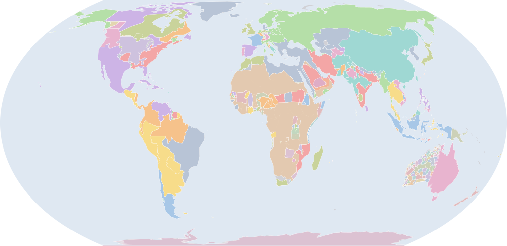
On 1 July 1814, IntMap’s historical map draws 442 names across the world. The borders for this date come from OpenHistoricalMap (day by day), then Cliopatria, Seshat Global History Databank (by year), then historical-basemaps — each drawn only where the records before it are silent. It also draws 7 outlines whose name the record does not give for this date.
Why this year has a page
Among the largest year-to-year changes in the records the map dates by year or by day: 42 names begin or stop being drawn between 1 July 1813 and 1 July 1814.
The year of Congress of Vienna (dated events index, Wikidata).
Names on the map
As the map labels them, largest first by the area of the outline drawn. Areas are of the drawn outline, rounded, and approximate. The record column says which record draws the outline; a Wikidata item is given where the record links one.
| Name | Record | Drawn area (km²) |
|---|---|---|
| Russian Empire | OpenHistoricalMap · historical-basemaps | 18,700,000 |
| Qing | OpenHistoricalMap | 13,300,000 |
| Antarctica | historical-basemaps | 12,200,000 |
| New Spain (1813-1819) | OpenHistoricalMap | 5,440,000 |
| State of Brazil | OpenHistoricalMap | 4,840,000 |
| Ottoman Empire | OpenHistoricalMap · Cliopatria Q12560 | 4,520,000 |
| United Provinces of the Río de la Plata | OpenHistoricalMap | 4,380,000 |
| Rupert's Land | OpenHistoricalMap | 4,200,000 |
| Colony of New South Wales | OpenHistoricalMap | 4,030,000 |
| Viceroyalty of New Granada | OpenHistoricalMap | 3,070,000 |
| North-West Territories | OpenHistoricalMap | 2,990,000 |
| State of Grão-Pará and Rio Negro | OpenHistoricalMap | 2,920,000 |
| United States | historical-basemaps | 2,610,000 |
| Denmark | OpenHistoricalMap | 2,570,000 |
| Kazakh Khanate | OpenHistoricalMap | 2,510,000 |
| Viceroyalty of Peru (1810-1814) | OpenHistoricalMap | 2,120,000 |
| Dutch East Indies | OpenHistoricalMap | 2,080,000 |
| Inner Provinces | OpenHistoricalMap | 1,830,000 |
| Russian America | OpenHistoricalMap | 1,730,000 |
| Persia | OpenHistoricalMap | 1,680,000 |
| Emirate of Diriyah | Cliopatria Q146871 | 1,630,000 |
| United States of America | Cliopatria Q30 | 1,550,000 |
| Kingdom of Chile | OpenHistoricalMap | 1,330,000 |
| Company Raj | OpenHistoricalMap | 1,310,000 |
| Columbia District | OpenHistoricalMap | 1,210,000 |
| Maratha Confederacy | OpenHistoricalMap · historical-basemaps | 1,170,000 |
| Venezuela | OpenHistoricalMap | 1,100,000 |
| Durrani Empire | Cliopatria Q467627 | 1,080,000 |
| Sweden–Norway | OpenHistoricalMap · historical-basemaps | 949,000 |
| Rattanakosin Kingdom Mandala | OpenHistoricalMap | 945,000 |
| Province of Lower Canada | OpenHistoricalMap | 933,000 |
| British Arctic Territories | OpenHistoricalMap | 884,000 |
| Captaincy-General of Mozambique, Sofala and Rivers of Sena | OpenHistoricalMap | 811,000 |
| Paraguay | OpenHistoricalMap | 690,000 |
| Sokoto Caliphate | OpenHistoricalMap · Cliopatria Q600524 | 675,000 |
| Austrian Empire | OpenHistoricalMap · Cliopatria Q131964 | 671,000 |
| Konbaung Dynasty | Cliopatria Q1062422 | 644,000 |
| Kingdom of Imerina | OpenHistoricalMap | 626,000 |
| Funj Sultanate | Cliopatria Q1475713 | 619,000 |
| British Empire | Cliopatria Q8680 | 614,000 |
| Kingdom of France | OpenHistoricalMap | 560,000 |
| Spain | OpenHistoricalMap | 529,000 |
| Tokugawa Shogunate | OpenHistoricalMap | 508,000 |
| Comancheria | OpenHistoricalMap | 486,000 |
| Regency of Algiers | OpenHistoricalMap | 462,000 |
| Khanate of Khiva | OpenHistoricalMap · Cliopatria Q491106 | 454,000 |
| Kaarta | historical-basemaps | 450,000 |
| Captaincy General of Guatemala | OpenHistoricalMap | 439,000 |
| Papou | historical-basemaps | 417,000 |
| Nejd | historical-basemaps | 410,000 |
All 442 names
| Name | Record | Drawn area (km²) |
|---|---|---|
| Province of Upper Canada | OpenHistoricalMap | 395,000 |
| Alawi Sultanate | OpenHistoricalMap | 392,000 |
| United Kingdom of Great Britain and Ireland | OpenHistoricalMap | 383,000 |
| Sultanate of Banjar | OpenHistoricalMap | 366,000 |
| Fulani Empire | historical-basemaps | 351,000 |
| Emirate of Bukhara | OpenHistoricalMap · Cliopatria Q746558 | 349,000 |
| Captaincy General of the Philippines | OpenHistoricalMap | 348,000 |
| Spanish Philippines | OpenHistoricalMap | 343,000 |
| Rajputana | OpenHistoricalMap | 343,000 |
| Lozi | historical-basemaps | 327,000 |
| Đại Việt | OpenHistoricalMap | 326,000 |
| Captaincy General of Cuba | OpenHistoricalMap | 322,000 |
| Sultanate of Darfur | Cliopatria Q1474791 | 296,000 |
| Wadai Empire | Cliopatria Q1132786 | 281,000 |
| British Cape Colony | Cliopatria Q370736 | 280,000 |
| New Caledonia | OpenHistoricalMap | 275,000 |
| Joseon | OpenHistoricalMap | 268,000 |
| Mossi States | historical-basemaps | 260,000 |
| Maori | historical-basemaps | 250,000 |
| Red River Colony | OpenHistoricalMap | 243,000 |
| Ethiopian Empire | Cliopatria Q207521 | 241,000 |
| New Galicia | OpenHistoricalMap | 230,000 |
| Bornu Empire | Cliopatria Q1139762 | 229,000 |
| Somalia | historical-basemaps | 226,000 |
| Khanate of Kalat | OpenHistoricalMap | 219,000 |
| Canada | historical-basemaps | 209,000 |
| Burundi | historical-basemaps | 199,000 |
| Intendency of Yucatán | OpenHistoricalMap | 198,000 |
| Rwanda | historical-basemaps | 190,000 |
| Spanish Empire | Cliopatria Q80702 | 185,000 |
| Shoshone | OpenHistoricalMap | 183,000 |
| Mardu | historical-basemaps | 172,000 |
| British occupation of Java | OpenHistoricalMap | 170,000 |
| Duchy of Warsaw | OpenHistoricalMap | 163,000 |
| Pintupi | historical-basemaps | 163,000 |
| Bunyoro | historical-basemaps | 162,000 |
| Kingdom of Prussia | OpenHistoricalMap | 161,000 |
| Khanate of Kokand | OpenHistoricalMap | 159,000 |
| Ashanti Empire | Cliopatria Q722071 | 151,000 |
| Suriname | OpenHistoricalMap | 148,000 |
| Morocco | Cliopatria · historical-basemaps Q1028 | 146,000 |
| British occupation of the Spice Islands | OpenHistoricalMap | 146,000 |
| Nepal | Cliopatria Q837 | 145,000 |
| Watjarri | historical-basemaps | 144,000 |
| Sind Sultanate | OpenHistoricalMap | 143,000 |
| Newfoundland Colony | OpenHistoricalMap | 141,000 |
| Warlpiri | historical-basemaps | 140,000 |
| Nyanganyatjara | historical-basemaps | 123,000 |
| Zanzibar | historical-basemaps | 122,000 |
| Omani Empire | OpenHistoricalMap | 118,000 |
| Majeerteen Sultanate | OpenHistoricalMap | 115,000 |
| Mirning | historical-basemaps | 114,000 |
| Kingdom of Lunda | Cliopatria Q1796223 | 113,000 |
| Assam | historical-basemaps | 111,000 |
| Zulu | historical-basemaps | 110,000 |
| Sultanate of Sulu | OpenHistoricalMap | 107,000 |
| Bamana Empire | Cliopatria Q762084 | 105,000 |
| Kokatha | historical-basemaps | 104,000 |
| Kalaamaya | historical-basemaps | 102,000 |
| Nyangumarda | historical-basemaps | 101,000 |
| Colony of New Brunswick | OpenHistoricalMap | 99,900 |
| Buganda | historical-basemaps | 98,400 |
| Kingdom of Portugal | OpenHistoricalMap | 93,300 |
| Sultanate of Qishn and Socotra | OpenHistoricalMap | 90,500 |
| Colony of French Guiana | OpenHistoricalMap | 86,600 |
| Wawula | historical-basemaps | 85,900 |
| Kingdom of Naples | OpenHistoricalMap | 85,700 |
| Awadh | OpenHistoricalMap | 85,200 |
| Malaya | historical-basemaps | 85,100 |
| Kingdom of Bavaria | Cliopatria Q154195 | 84,700 |
| Vice-Royalty of New Spain | historical-basemaps | 81,800 |
| Kazembe | historical-basemaps | 81,500 |
| Ngatatjara | historical-basemaps | 77,000 |
| Colony of Sierra Leone | OpenHistoricalMap | 76,500 |
| Ngaanyatjarra | historical-basemaps | 75,400 |
| British Ceylon | OpenHistoricalMap | 73,800 |
| Confederation of the Rhine | Cliopatria Q154741 | 71,300 |
| Mandjindja | historical-basemaps | 70,800 |
| Oyo Empire | Cliopatria Q849623 | 70,100 |
| Australian aboriginal hunter-gatherers (a description by the source, not a name) | historical-basemaps | 68,600 |
| Luritja | historical-basemaps | 68,100 |
| Wangkathaa | historical-basemaps | 66,200 |
| Yankuntjatjara | historical-basemaps | 66,000 |
| Kingdom of Sardinia | Cliopatria Q2577303 | 65,800 |
| Omani Slave Coast | Cliopatria | 65,300 |
| Arrernte | historical-basemaps | 65,200 |
| Sultanate of Maguindanao | OpenHistoricalMap | 64,900 |
| Pitjantjatjara | historical-basemaps | 64,200 |
| Nakako | historical-basemaps | 64,000 |
| Kalaako/Malpa | historical-basemaps | 63,800 |
| Sikh Empire | Cliopatria Q83572 | 63,200 |
| Wirangu | historical-basemaps | 62,300 |
| Sultanate of Johor | Cliopatria Q1150344 | 62,100 |
| Grand Duchy of Berg | Cliopatria Q249428 | 61,300 |
| Asante | historical-basemaps | 61,200 |
| Nkore | historical-basemaps | 61,200 |
| Captaincy General of Santo Domingo | OpenHistoricalMap | 60,200 |
| New South Wales | historical-basemaps | 57,600 |
| Colony of Nova Scotia | OpenHistoricalMap | 56,900 |
| Yulparitja | historical-basemaps | 56,400 |
| Ngarinyin | historical-basemaps | 55,600 |
| Bhutan | OpenHistoricalMap | 55,100 |
| Wudjari | historical-basemaps | 54,700 |
| Portuguese Empire | Cliopatria Q200464 | 53,800 |
| Angola | historical-basemaps | 53,200 |
| Lunda | historical-basemaps | 53,000 |
| Warumungu | historical-basemaps | 53,000 |
| Rozvi | OpenHistoricalMap | 52,600 |
| Ethiopia | historical-basemaps | 52,400 |
| Colony of the Bahamas | OpenHistoricalMap | 51,400 |
| Sultanate of Brunei | Cliopatria Q887803 | 48,200 |
| Kuwarra | historical-basemaps | 48,200 |
| Kija | historical-basemaps | 47,900 |
| Portuguese Timor | OpenHistoricalMap | 47,800 |
| Imamate of Futa Toro | OpenHistoricalMap | 47,000 |
| Colony of Berbice | OpenHistoricalMap | 46,500 |
| Tjupany | historical-basemaps | 46,400 |
| Nyamal | historical-basemaps | 45,400 |
| Ngarti | historical-basemaps | 44,900 |
| Bahawalpur State | OpenHistoricalMap | 44,800 |
| Nyaki-nyaki | historical-basemaps | 44,800 |
| Ngalea | historical-basemaps | 43,800 |
| Imamate of Yemen | Cliopatria | 42,600 |
| Kingdom of Haiti | OpenHistoricalMap | 42,400 |
| Sotho | historical-basemaps | 42,000 |
| Portuguese Guinea | OpenHistoricalMap | 41,700 |
| Mangala | historical-basemaps | 41,500 |
| Antakarinja | historical-basemaps | 41,400 |
| Sovereign Principality of the United Netherlands | OpenHistoricalMap | 40,500 |
| Jaru | historical-basemaps | 40,300 |
| Kingdom of Rwanda | OpenHistoricalMap | 40,000 |
| Kingdom of Saxony | OpenHistoricalMap | 38,100 |
| Tjalkanti | historical-basemaps | 37,600 |
| Kukatja | historical-basemaps | 36,900 |
| Warlmanpa | historical-basemaps | 36,900 |
| Mudburra | historical-basemaps | 36,800 |
| Papal States | Cliopatria Q170174 | 36,800 |
| Egypt | historical-basemaps | 35,600 |
| J'rai | OpenHistoricalMap | 35,100 |
| Walmatjarri | historical-basemaps | 34,800 |
| Nana | historical-basemaps | 34,300 |
| Swiss Confederation | OpenHistoricalMap | 33,200 |
| Gurindji | historical-basemaps | 32,700 |
| Palyku | historical-basemaps | 32,400 |
| Ngatjumay | historical-basemaps | 31,800 |
| Nyikina | historical-basemaps | 31,700 |
| Kingdom of Sicily | OpenHistoricalMap | 31,500 |
| Badimaya | historical-basemaps | 31,400 |
| Sultanate of the Maldive Islands | OpenHistoricalMap | 31,300 |
| Kaytej | historical-basemaps | 30,700 |
| Amangu | historical-basemaps | 28,400 |
| Hawaiian Kingdom | OpenHistoricalMap | 28,400 |
| Kingdom of Burundi | OpenHistoricalMap | 26,900 |
| Colony of Demerara-Essequibo | OpenHistoricalMap | 26,600 |
| Banjima | historical-basemaps | 25,700 |
| Kurrama | historical-basemaps | 25,200 |
| Ballardong | historical-basemaps | 25,200 |
| Sultanate of Oman | Cliopatria Q842 | 24,300 |
| Jawoyn | historical-basemaps | 24,200 |
| Tuʻi Tonga Empire | historical-basemaps | 24,200 |
| Anmatyerre | historical-basemaps | 24,200 |
| Sultanate of Perak | Cliopatria | 23,900 |
| Oyo | historical-basemaps | 23,700 |
| Yangman | historical-basemaps | 23,400 |
| Alawa | historical-basemaps | 23,400 |
| British Bencoolen | OpenHistoricalMap | 23,100 |
| Nhanta | historical-basemaps | 22,900 |
| Manipur State | OpenHistoricalMap | 22,400 |
| Ngarinman | historical-basemaps | 22,000 |
| Jingili | historical-basemaps | 21,700 |
| Worla | historical-basemaps | 21,300 |
| Louisiana Neutral Ground | OpenHistoricalMap | 20,600 |
| Kingdom of Jolof | OpenHistoricalMap | 20,500 |
| Yinggarda | historical-basemaps | 20,500 |
| Kingdom of Dahomey | OpenHistoricalMap | 20,400 |
| Wiilman | historical-basemaps | 20,200 |
| Burma | historical-basemaps | 20,100 |
| Württemberg | OpenHistoricalMap | 19,600 |
| Yuat | historical-basemaps | 19,500 |
| Minang | historical-basemaps | 19,300 |
| Qajar Dynasty | Cliopatria Q189326 | 19,200 |
| Bundu | OpenHistoricalMap | 18,900 |
| Ngalawangka | historical-basemaps | 18,800 |
| Doolboong/Miriwoong | historical-basemaps | 18,400 |
| Maya | historical-basemaps | 17,400 |
| Kingdom of Saloum | OpenHistoricalMap | 17,200 |
| Wardaman | historical-basemaps | 17,100 |
| Kaniyang | historical-basemaps | 16,900 |
| Yindjibarndi | historical-basemaps | 16,900 |
| Shilluk Kingdom | OpenHistoricalMap | 16,800 |
| Republic of Haiti | OpenHistoricalMap | 16,500 |
| Thiin | historical-basemaps | 16,300 |
| British Mauritius | OpenHistoricalMap | 16,000 |
| Wagiman | historical-basemaps | 15,800 |
| Yemen | historical-basemaps | 15,800 |
| Colony of Cape Breton | OpenHistoricalMap | 15,600 |
| Xhosa | historical-basemaps | 15,300 |
| Baden | OpenHistoricalMap | 15,300 |
| Governorate of Chiloe | OpenHistoricalMap | 15,100 |
| Sultanate of Terengganu | Cliopatria Q5769444 | 14,900 |
| Colony of Jamaica | OpenHistoricalMap | 14,700 |
| Principality of Thuận Thành | OpenHistoricalMap | 14,400 |
| Kingdom of Cayor | OpenHistoricalMap | 14,100 |
| Captaincy General of Puerto Rico | OpenHistoricalMap | 14,100 |
| Duchy of Mecklenburg-Schwerin | OpenHistoricalMap | 13,900 |
| Nhuwala | historical-basemaps | 13,800 |
| Goreng | historical-basemaps | 13,800 |
| Yinhawangka | historical-basemaps | 13,500 |
| Unggumi | historical-basemaps | 13,300 |
| Tharrgari | historical-basemaps | 13,200 |
| Payungu | historical-basemaps | 13,200 |
| Kariyarra | historical-basemaps | 12,400 |
| Imbangala | historical-basemaps | 12,300 |
| Warriyangga | historical-basemaps | 12,100 |
| Sultanate of Selangor | Cliopatria | 11,800 |
| Kingdom of Niani | OpenHistoricalMap | 11,700 |
| Jaminjung | historical-basemaps | 11,600 |
| Sultanate of Kedah | Cliopatria Q1317579 | 11,400 |
| Oman | historical-basemaps | 11,300 |
| Thalanyji | historical-basemaps | 11,000 |
| Grand Duchy of Hesse | OpenHistoricalMap | 10,900 |
| British Settlements on the Bay of Honduras | OpenHistoricalMap | 10,900 |
| Gooniyandi | historical-basemaps | 10,800 |
| Maratha Empire | Cliopatria Q83618 | 10,700 |
| British East India Company | historical-basemaps | 10,600 |
| Kingdom of Luang Phrabang | Cliopatria | 10,500 |
| Ryukyu Kingdom | OpenHistoricalMap | 10,500 |
| Bibbulman | historical-basemaps | 10,300 |
| Purduna | historical-basemaps | 9,660 |
| Sultanate of Lahej | OpenHistoricalMap | 9,630 |
| Wajuk | historical-basemaps | 9,620 |
| Prince Edward Island Colony | OpenHistoricalMap | 9,580 |
| Worora | historical-basemaps | 9,430 |
| Malkana | historical-basemaps | 9,260 |
| Dutch Gold Coast | Cliopatria Q770776 | 9,120 |
| Ngalakan | historical-basemaps | 8,900 |
| Karangpurru | historical-basemaps | 8,880 |
| Karajarri | historical-basemaps | 8,820 |
| Kelantan | Cliopatria Q185944 | 8,610 |
| Bilinara | historical-basemaps | 8,540 |
| Wunambul | historical-basemaps | 8,250 |
| Sarawak | OpenHistoricalMap | 8,190 |
| British Colonial Empire | Cliopatria Q8680 | 8,180 |
| Kingdom of Baol | OpenHistoricalMap | 8,170 |
| Warray | historical-basemaps | 8,160 |
| Jiwarli | historical-basemaps | 7,940 |
| Colony of Trinidad | OpenHistoricalMap | 7,680 |
| Gunwinggu | historical-basemaps | 7,220 |
| Danish Gold Coast | OpenHistoricalMap | 6,910 |
| Alyawarre | historical-basemaps | 6,830 |
| Kungarakany | historical-basemaps | 6,580 |
| Kwini | historical-basemaps | 6,510 |
| Jurruru | historical-basemaps | 6,430 |
| Dangbon | historical-basemaps | 6,380 |
| Duchy of Parma and Piacenza | OpenHistoricalMap | 6,070 |
| Kingdom of Kakongo | OpenHistoricalMap | 6,050 |
| Ngan’giwumirri | historical-basemaps | 5,970 |
| Negeri Sembilan | Cliopatria Q213893 | 5,930 |
| Kadjerong | historical-basemaps | 5,910 |
| Punuba | historical-basemaps | 5,830 |
| Pinikura | historical-basemaps | 5,780 |
| Spanish Possessions on the Gulf of Guinea | OpenHistoricalMap | 5,750 |
| Electorate of Hesse | Cliopatria Q529605 | 5,740 |
| Rembarnga | historical-basemaps | 5,700 |
| Nimanburu | historical-basemaps | 5,640 |
| Kingdom of Waalo | OpenHistoricalMap | 5,570 |
| Kingdom of Wuli | OpenHistoricalMap | 5,410 |
| British Guiana | OpenHistoricalMap | 5,330 |
| Helvetic Republic | Cliopatria Q206696 | 5,270 |
| Mangarayi | historical-basemaps | 5,240 |
| Duchy of Nassau | Cliopatria Q836680 | 5,190 |
| Wuningangk | historical-basemaps | 5,100 |
| Ngarluma | historical-basemaps | 4,950 |
| Portuguese East Africa | historical-basemaps | 4,710 |
| Martuthunira | historical-basemaps | 4,600 |
| Warwa | historical-basemaps | 4,520 |
| Malak malak | historical-basemaps | 4,500 |
| Yawuru | historical-basemaps | 4,500 |
| Ngaliwuru | historical-basemaps | 4,410 |
| Duchy of Oldenburg | Cliopatria Q697084 | 4,380 |
| Colony of Guadelupe | OpenHistoricalMap | 4,380 |
| Limilngan | historical-basemaps | 4,370 |
| Prince-Bishopric of Montenegro | OpenHistoricalMap | 4,310 |
| Kingdom of Coorg | OpenHistoricalMap | 4,130 |
| Miwa | historical-basemaps | 3,950 |
| Isle Bourbon | OpenHistoricalMap | 3,930 |
| Kingdom of Ngoyo | OpenHistoricalMap | 3,920 |
| Woolna | historical-basemaps | 3,910 |
| Ngumbarl | historical-basemaps | 3,850 |
| Wardandi | historical-basemaps | 3,820 |
| Gamberre | historical-basemaps | 3,730 |
| Nungali | historical-basemaps | 3,720 |
| Larrakia | historical-basemaps | 3,720 |
| Brunswick | OpenHistoricalMap | 3,700 |
| Murrinh-patha | historical-basemaps | 3,620 |
| Republic of Kraków | historical-basemaps | 3,600 |
| Bornu-Kanem | historical-basemaps | 3,490 |
| Ligurian Republic | Cliopatria Q659312 | 3,290 |
| French India | OpenHistoricalMap · Cliopatria Q646374 | 3,280 |
| Ngarla | historical-basemaps | 3,190 |
| Septinsular Republic | Cliopatria Q1077630 | 3,170 |
| Umida | historical-basemaps | 2,990 |
| Jabirrjabirr | historical-basemaps | 2,740 |
| Principality of Reuss-Gera | OpenHistoricalMap · Cliopatria Q639100 | 2,710 |
| Yiiji | historical-basemaps | 2,700 |
| Duchy of Mecklenburg-Strelitz | OpenHistoricalMap | 2,630 |
| Iwaidja | historical-basemaps | 2,590 |
| Saxe-Altenburg | Cliopatria Q158151 | 2,570 |
| Portuguese São Tomé and Príncipe | OpenHistoricalMap | 2,560 |
| Arakan | historical-basemaps | 2,520 |
| Kingdom of Sine | OpenHistoricalMap | 2,320 |
| Grand Duchy of Saxe-Weimar-Eisenach | Cliopatria Q155570 | 2,300 |
| Bavaria | historical-basemaps | 2,270 |
| Ngalkbun | historical-basemaps | 2,200 |
| Amarak | historical-basemaps | 2,200 |
| Sultanate of Ndzuwani | OpenHistoricalMap | 2,180 |
| Confederate States of Lanao | OpenHistoricalMap | 2,060 |
| Colony of St Vincent and the Grenadines | OpenHistoricalMap | 2,030 |
| Unggarangi | historical-basemaps | 1,980 |
| Palatinate | historical-basemaps | 1,970 |
| Danish West Indies | OpenHistoricalMap | 1,890 |
| Haushabi Sultanate | OpenHistoricalMap | 1,860 |
| Marrithiyel | historical-basemaps | 1,810 |
| Pinjarup | historical-basemaps | 1,800 |
| Jukun | historical-basemaps | 1,780 |
| Gagudju | historical-basemaps | 1,760 |
| Kundjey’mi | historical-basemaps | 1,680 |
| Sultanate of Maore | OpenHistoricalMap | 1,620 |
| Congo | historical-basemaps | 1,610 |
| Walvis Bay Colony | OpenHistoricalMap | 1,610 |
| Lucca | historical-basemaps | 1,600 |
| Colony of Dominica | OpenHistoricalMap | 1,570 |
| Venetia | historical-basemaps | 1,540 |
| Cayman Islands | OpenHistoricalMap | 1,520 |
| Nyul Nyul | historical-basemaps | 1,510 |
| Colony of Grenada | OpenHistoricalMap | 1,480 |
| Hanover | historical-basemaps | 1,470 |
| Marringarr | historical-basemaps | 1,390 |
| Colony of Saint Lucia | OpenHistoricalMap | 1,360 |
| Isle of Man | OpenHistoricalMap | 1,350 |
| Konbudj | historical-basemaps | 1,330 |
| Principality of Hohenzollern-Sigmaringen | Cliopatria Q157013 | 1,310 |
| Mbukarla | historical-basemaps | 1,240 |
| Principality of Lippe | OpenHistoricalMap | 1,210 |
| Martinique | historical-basemaps | 1,200 |
| Ngombur | historical-basemaps | 1,170 |
| Kahlur State | OpenHistoricalMap | 1,170 |
| Saint Pierre and Miquelon | OpenHistoricalMap | 1,100 |
| Waldeck | OpenHistoricalMap | 1,050 |
| Colony of Barbados | OpenHistoricalMap | 1,020 |
| Colony of Tobago | OpenHistoricalMap | 1,020 |
| Jersey | OpenHistoricalMap | 984 |
| Principality of Schwarzburg-Rudolstadt | OpenHistoricalMap | 940 |
| Crown Colony of Malta | OpenHistoricalMap | 925 |
| Guernsey | OpenHistoricalMap | 909 |
| Hohenzollern-Sigmaringen | OpenHistoricalMap | 902 |
| Principality of Schwarzburg-Sondershausen | OpenHistoricalMap | 851 |
| Duchy of Anhalt-Dessau | OpenHistoricalMap | 842 |
| Duchy of Anhalt-Bernburg | OpenHistoricalMap | 809 |
| Maranunggu | historical-basemaps | 797 |
| Principality Isenburg | OpenHistoricalMap | 763 |
| Ngan’gikurunggurr | historical-basemaps | 759 |
| Duchy of Anhalt-Köthen | OpenHistoricalMap | 682 |
| Portuguese India | OpenHistoricalMap | 654 |
| Gunbalang | historical-basemaps | 653 |
| Principality of Elba | OpenHistoricalMap | 650 |
| Gungurugoni | historical-basemaps | 612 |
| French Tourane | OpenHistoricalMap | 590 |
| Colony of Bermuda | OpenHistoricalMap | 555 |
| Saint Helena Colony | OpenHistoricalMap | 508 |
| Maung | historical-basemaps | 487 |
| Andorra | OpenHistoricalMap | 467 |
| Bukurnidja | historical-basemaps | 410 |
| Marramaninjsji | historical-basemaps | 409 |
| Gunibidji | historical-basemaps | 394 |
| Schaumburg-Lippe | OpenHistoricalMap | 341 |
| Principality of Reuss-Greiz | OpenHistoricalMap | 312 |
| Kuwema | historical-basemaps | 303 |
| Bremen | OpenHistoricalMap | 257 |
| Bardi | historical-basemaps | 249 |
| Hohenzollern-Hechingen | OpenHistoricalMap | 228 |
| Duchy of Massa and Carrara | OpenHistoricalMap | 215 |
| Polynesians | historical-basemaps | 192 |
| Principality of Monaco | Cliopatria Q235 | 164 |
| Heligoland | OpenHistoricalMap | 156 |
| Liechtenstein | OpenHistoricalMap | 156 |
| Tjerratj | historical-basemaps | 93.9 |
| Sacramento Colony | OpenHistoricalMap | 85.7 |
| Pyrmont | OpenHistoricalMap | 65.2 |
| San Marino | OpenHistoricalMap | 60.1 |
| Couto Misto | OpenHistoricalMap | 23.1 |
| Jaburrara | historical-basemaps | 3.38 |
What changed since 1811
Names counted are those the records date to the year or the day (CShapes, OpenHistoricalMap, Cliopatria). Outlines filled from the nearest historical-basemaps sheet are counted only when both years are years that sheet was drawn for — otherwise the change would be the switch between two sheets, not a change in the world. Names are compared as written, so a polity a record names differently in the two years (Carthaginian Empire, then Carthage) is in both lists.
Now drawn (29)
New Spain (1813-1819), Denmark, Persia, Venezuela, Sweden–Norway, Kingdom of France, British occupation of Java, Confederation of the Rhine, Omani Slave Coast, Imamate of Yemen, Sovereign Principality of the United Netherlands, Papal States, Colony of Demerara-Essequibo, Duchy of Parma and Piacenza, Electorate of Hesse, Helvetic Republic, Duchy of Nassau, Duchy of Oldenburg, Colony of Guadelupe, Brunswick, Ligurian Republic, Saxe-Altenburg, Grand Duchy of Saxe-Weimar-Eisenach, Saint Pierre and Miquelon, Crown Colony of Malta, Principality of Elba, Bremen, Duchy of Massa and Carrara, Principality of Monaco
No longer drawn (16)
New Spain (1809-1813), Denmark–Norway, Qajar Iran, Captaincy General of Venezuela, French Empire, Sweden, Kingdom of Italy, Kingdom of Westphalia, Colony of Demerara, Colony of Essequibo, Principality of Regensberg, Principality of Lucca and Piombino, Free City of Danzig, British Protectorate of Malta, Principality of Neuchâtel, Principality of Leyen
Events dated to 1814
Every record of IntMap’s one index of dated events whose date falls in this year: what the border record (CShapes 2.0) states about its own outlines, IntMap’s war record, and the world events Wikidata dates — each with its source and the precision of its date.
- 1814
Congress of Vienna
conference of ambassadors of European states (September/November 1814 to June 1815)
began 1814-09 · Wikidata Q46362
Sources and method
Borders and names: OpenHistoricalMap (openhistoricalmap.org) · CC0 1.0 + Cliopatria v0.2.1 (Seshat Global History Databank, github.com/Seshat-Global-History-Databank/cliopatria) · CC BY 4.0 · adapted by IntMap: simplified, BC years made astronomical, and the ground OpenHistoricalMap (1689–1885, and from 1886 where CShapes is silent) and CShapes (1886–2019) state removed on their own dates + aourednik/historical-basemaps (github.com/aourednik/historical-basemaps) · GPL-3.0 · adapted by IntMap: each sheet before 1886 less the ground OpenHistoricalMap and Cliopatria state at that sheet's year.
Which years have a page is worked out when the site is built, from three rules applied to the records themselves: every year the historical-basemaps atlas drew a world sheet for; every year whose change from the year before (names the dated records begin or stop drawing) is in the top 5% of all such year-to-year changes since the dated records begin, leaving out the years where one record hands over to another; and every year of a geopolitical, war or revolution event in the dated events index, up to the last year the border records cover (2019).
On each year the map is read on 1 July, the instant the app’s own year links open on. Names are the source’s own, translated where the source or IntMap’s name table has a translation. A name is what a record draws there, not a verdict of history.
World map in 1814 — the map, with the years it stays the same Historical maps by region Countries On this day