The world in 1,000 BC
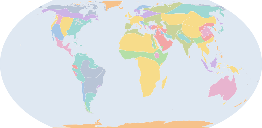
On 1 July 1,000 BC, IntMap’s historical map draws 77 names across the world. The borders for this date come from Cliopatria, Seshat Global History Databank (by year), then historical-basemaps — each drawn only where the records before it are silent. It also draws 94 outlines whose name the record does not give for this date.
Why this year has a page
The historical-basemaps atlas drew a world sheet for this year.
Names on the map
As the map labels them, largest first by the area of the outline drawn. Areas are of the drawn outline, rounded, and approximate. The record column says which record draws the outline; a Wikidata item is given where the record links one.
| Name | Record | Drawn area (km²) |
|---|---|---|
| Khoiasan | historical-basemaps | 11,700,000 |
| Saharan pastoral nomads (a description by the source, not a name) | historical-basemaps | 9,860,000 |
| Australian aboriginal hunter-gatherers (a description by the source, not a name) | historical-basemaps | 7,600,000 |
| Paleo-Siberian hunter-gatherers (a description by the source, not a name) | historical-basemaps | 7,170,000 |
| West African cereal farmers (a description by the source, not a name) | historical-basemaps | 6,030,000 |
| Arctic marine mammal hunters (a description by the source, not a name) | historical-basemaps | 5,910,000 |
| Proto-Altaic pastoralists (a description by the source, not a name) | historical-basemaps | 4,990,000 |
| Savanna hunter-gatherers (a description by the source, not a name) | historical-basemaps | 4,820,000 |
| Manioc farmers (a description by the source, not a name) | historical-basemaps | 4,770,000 |
| Subarctic forest hunter-gatherers (a description by the source, not a name) | historical-basemaps | 4,440,000 |
| Karasuk culture | historical-basemaps | 4,360,000 |
| Amazon hunter-gatherers (a description by the source, not a name) | historical-basemaps | 4,280,000 |
| Eastern North Amercian hunter-gatherers (a description by the source, not a name) | historical-basemaps | 3,600,000 |
| Finno-Ugric taiga hunter-gatherers (a description by the source, not a name) | historical-basemaps | 3,530,000 |
| Tibetans | historical-basemaps | 3,310,000 |
| Plain bison hunters (a description by the source, not a name) | historical-basemaps | 2,850,000 |
| Iranian pastoralists (a description by the source, not a name) | historical-basemaps | 2,830,000 |
| Dravidians | historical-basemaps | 2,650,000 |
| Arabian pastoral nomads (a description by the source, not a name) | historical-basemaps | 2,620,000 |
| Desert hunter-gatherers (a description by the source, not a name) | historical-basemaps | 2,350,000 |
| Austro-Asiatic rice farmers (a description by the source, not a name) | historical-basemaps | 2,200,000 |
| Cimerians | historical-basemaps | 2,200,000 |
| N. European Bronze Age cultures (a description by the source, not a name) | historical-basemaps | 1,970,000 |
| Pampas cultures (a description by the source, not a name) | historical-basemaps | 1,830,000 |
| Urnfield cultures (a description by the source, not a name) | historical-basemaps | 1,810,000 |
| Sinic | historical-basemaps | 1,680,000 |
| Maize farmers (a description by the source, not a name) | historical-basemaps | 1,590,000 |
| Austronesians | historical-basemaps | 1,280,000 |
| Berbers | historical-basemaps | 1,100,000 |
| Papuan neolithic farmers (a description by the source, not a name) | historical-basemaps | 1,050,000 |
| Vedic Aryans | historical-basemaps | 997,000 |
| Burmese | historical-basemaps | 961,000 |
| Andean hunter-gatherers (a description by the source, not a name) | historical-basemaps | 744,000 |
| Plateau fichers and hunter gatherers (a description by the source, not a name) | historical-basemaps | 722,000 |
| Zhou Dynasty | Cliopatria Q35216 | 700,000 |
| Saami | historical-basemaps | 631,000 |
| Zhoa | historical-basemaps | 630,000 |
| Celtiberians | historical-basemaps | 552,000 |
| North American Pacifi foraging, hunting and fishing peoples | historical-basemaps | 533,000 |
| Caribbean hunter-gatherers (a description by the source, not a name) | historical-basemaps | 513,000 |
| Elam | Cliopatria · historical-basemaps Q128904 | 431,000 |
| Arameans | historical-basemaps | 411,000 |
| Hittites | historical-basemaps | 378,000 |
| Ethiopian highland farmers (a description by the source, not a name) | historical-basemaps | 376,000 |
| state societies and Aramaean kingdoms (a description by the source, not a name) | historical-basemaps | 367,000 |
| New Kingdom of Egypt | Cliopatria | 342,000 |
| Kingdom of Kush | Cliopatria Q241790 | 337,000 |
| Late Jomon culture (a description by the source, not a name) | historical-basemaps | 281,000 |
| Chorrera | historical-basemaps | 262,000 |
| Patagonian shellfish and marine mammal hunters (a description by the source, not a name) | historical-basemaps | 259,000 |
All 77 names
| Name | Record | Drawn area (km²) |
|---|---|---|
| Thrace | historical-basemaps | 256,000 |
| Illyrians | historical-basemaps | 221,000 |
| Phrygians | historical-basemaps | 183,000 |
| Assyria | Cliopatria · historical-basemaps Q41137 | 174,000 |
| Ainu | historical-basemaps | 159,000 |
| El Paraiso | historical-basemaps | 157,000 |
| Paleo-Koreans | historical-basemaps | 150,000 |
| Shellfish gatherers (a description by the source, not a name) | historical-basemaps | 149,000 |
| Gandhara grave culture | historical-basemaps | 125,000 |
| Kingdom of David and Solomon | historical-basemaps | 123,000 |
| Babylonia | Cliopatria · historical-basemaps Q47690 | 119,000 |
| Wu | historical-basemaps | 105,000 |
| Saba | historical-basemaps | 104,000 |
| Greek city-states (a description by the source, not a name) | historical-basemaps | 103,000 |
| Chavin | historical-basemaps | 82,900 |
| Kush | historical-basemaps | 70,600 |
| Greek Dark Ages | Cliopatria Q210443 | 61,400 |
| Tasmanian hunter-gatherers (a description by the source, not a name) | historical-basemaps | 59,400 |
| Olmec | historical-basemaps | 48,700 |
| Chinchoros | historical-basemaps | 45,900 |
| Neo-Hittite states | Cliopatria Q770281 | 25,000 |
| Egypt | historical-basemaps | 23,800 |
| Kingdom of Israel | Cliopatria Q3185305 | 20,100 |
| Phoenicia | Cliopatria Q41642 | 13,000 |
| Phoenician Empire | Cliopatria Q41642 | 13,000 |
| Guanches | historical-basemaps | 9,080 |
| Philistia | Cliopatria Q7185566 | 7,640 |
What changed since 1,500 BC
Names counted are those the records date to the year or the day (CShapes, OpenHistoricalMap, Cliopatria). Outlines filled from the nearest historical-basemaps sheet are counted only when both years are years that sheet was drawn for — otherwise the change would be the switch between two sheets, not a change in the world. Names are compared as written, so a polity a record names differently in the two years (Carthaginian Empire, then Carthage) is in both lists.
Now drawn (10)
Zhou Dynasty, Kingdom of Kush, Gandhara grave culture, Chavin, Greek Dark Ages, Neo-Hittite states, Kingdom of Israel, Phoenicia, Phoenician Empire, Philistia
No longer drawn (7)
Mitanni, Shang Dynasty, Poverty point culture, Hyksos, Mycenaean Greece, First Sealand Dynasty, Minoan civilization
Events dated to 1,000 BC
The index of dated events holds no event for 1,000 BC.
Sources and method
Borders and names: Cliopatria v0.2.1 (Seshat Global History Databank, github.com/Seshat-Global-History-Databank/cliopatria) · CC BY 4.0 · adapted by IntMap: simplified, BC years made astronomical, and the ground OpenHistoricalMap (1689–1885, and from 1886 where CShapes is silent) and CShapes (1886–2019) state removed on their own dates + aourednik/historical-basemaps (github.com/aourednik/historical-basemaps) · GPL-3.0 · adapted by IntMap: each sheet before 1886 less the ground OpenHistoricalMap and Cliopatria state at that sheet's year.
Which years have a page is worked out when the site is built, from three rules applied to the records themselves: every year the historical-basemaps atlas drew a world sheet for; every year whose change from the year before (names the dated records begin or stop drawing) is in the top 5% of all such year-to-year changes since the dated records begin, leaving out the years where one record hands over to another; and every year of a geopolitical, war or revolution event in the dated events index, up to the last year the border records cover (2019).
On each year the map is read on 1 July, the instant the app’s own year links open on. Names are the source’s own, translated where the source or IntMap’s name table has a translation. A name is what a record draws there, not a verdict of history.
World map in 1,000 BC — the map, with the years it stays the same Historical maps by region Countries On this day