800年の世界
800年7月1日、IntMap の歴史地図は世界に190の名前を描きます。この日付の国境はSeshat Global History Databank の Cliopatria(年単位)、次にhistorical-basemaps(各記録は、前の記録が述べていない土地にだけ描く)によります。 このほか、この日付について記録が名前を与えていない輪郭を100描いています。
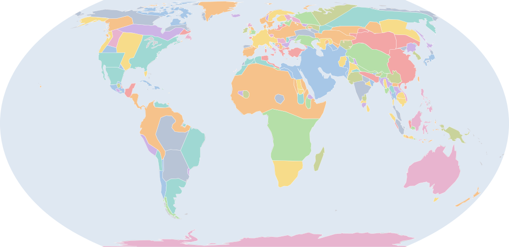
この年にページがある理由
historical-basemaps の地図帳がこの年の世界図を描いています。
地図に描かれる名前
地図が書く名前で、描かれる輪郭の面積が大きい順に並べています。面積は描かれた輪郭のもので、丸めた概算です。「記録」はその輪郭を描く記録で、記録が Wikidata の項目を結んでいる場合はそれを示します。
| 名前 | 出典の綴り | 記録 | 描かれる面積(km²) |
|---|---|---|---|
| 南極 | Antarctica | historical-basemaps | 12,200,000 |
| Bantou | historical-basemaps | 8,810,000 | |
| アッバース朝 | Abbasid Caliphate | Cliopatria · historical-basemaps Q12536 | 8,590,000 |
| オーストラリア先住民の狩猟採集民 (出典による説明で、名前ではない) | Australian aboriginal hunter-gatherers | historical-basemaps | 7,600,000 |
| 古シベリア系の狩猟採集民 (出典による説明で、名前ではない) | Paleo-Siberian hunter-gatherers | historical-basemaps | 5,570,000 |
| 西アフリカの穀作農耕民 (出典による説明で、名前ではない) | West African cereal farmers | historical-basemaps | 5,110,000 |
| 吐蕃 | Tibetan Empire | Cliopatria · historical-basemaps Q2431480 | 4,230,000 |
| 北極圏の海獣狩猟民 (出典による説明で、名前ではない) | Arctic marine mammal hunters | historical-basemaps | 4,190,000 |
| 北米東部の狩猟採集民 (出典による説明で、名前ではない) | Eastern North Amercian hunter-gatherers | historical-basemaps | 3,540,000 |
| アマゾンの狩猟採集民 (出典による説明で、名前ではない) | Amazon hunter-gatherers | historical-basemaps | 3,200,000 |
| 唐 | Tang Dynasty | Cliopatria Q9683 | 3,100,000 |
| サバンナの狩猟採集民 (出典による説明で、名前ではない) | Savanna hunter-gatherers | historical-basemaps | 3,050,000 |
| 回鶻 | Uyghur Khaganate | Cliopatria Q831218 | 3,020,000 |
| トゥピ人 | Tupis | historical-basemaps | 2,960,000 |
| Khoiasan | historical-basemaps | 2,640,000 | |
| 平原のバイソン狩猟民 (出典による説明で、名前ではない) | Plain bison hunters | historical-basemaps | 2,620,000 |
| フランク王国 | Kingdom of the Franks | Cliopatria Q146246 | 2,560,000 |
| 亜寒帯林の狩猟採集民 (出典による説明で、名前ではない) | Subarctic forest hunter-gatherers | historical-basemaps | 2,450,000 |
| フィン・ウゴル系タイガの狩猟採集民 (出典による説明で、名前ではない) | Finno-Ugric taiga hunter-gatherers | historical-basemaps | 2,060,000 |
| Tungus | historical-basemaps | 2,000,000 | |
| Dorset | historical-basemaps | 1,890,000 | |
| パンパの諸文化 (出典による説明で、名前ではない) | Pampas cultures | historical-basemaps | 1,830,000 |
| スラヴ諸部族 (出典による説明で、名前ではない) | Slavonic tribes | historical-basemaps | 1,640,000 |
| Anasazi | historical-basemaps | 1,550,000 | |
| キメック・ハン国 | Kimek-Kipchak confederation | Cliopatria Q2477776 | 1,420,000 |
| フランク王国 | Carolingian Empire | Cliopatria · historical-basemaps Q146246 | 1,340,000 |
| Athabaskan | historical-basemaps | 1,210,000 | |
| Mogollon | historical-basemaps | 1,090,000 | |
| Ouighurs | historical-basemaps | 1,060,000 | |
| Permians | historical-basemaps | 1,020,000 | |
| Malay | historical-basemaps | 988,000 | |
| ラーシュトラクータ朝 | Rashtrakuta Dynasty | Cliopatria Q856691 | 914,000 |
| 東ローマ帝国 | Byzantine Empire | Cliopatria · historical-basemaps Q12544 | 823,000 |
| Papou | historical-basemaps | 801,000 | |
| ハザール | Khazaria | Cliopatria Q173282 | 747,000 |
| 高原の漁労民・狩猟採集民 (出典による説明で、名前ではない) | Plateau fichers and hunter gatherers | historical-basemaps | 677,000 |
| ハザール | Khazars | historical-basemaps | 637,000 |
| プラティハーラ朝 | Gurjara-Pratihara Dynasty | Cliopatria Q5324 | 629,000 |
| Sámi | historical-basemaps | 624,000 | |
| 南詔 | Nanzhao | Cliopatria Q1045322 | 592,000 |
| アンデスの狩猟採集民 (出典による説明で、名前ではない) | Andean hunter-gatherers | historical-basemaps | 582,000 |
| Malagasy | historical-basemaps | 580,000 | |
| Thule | historical-basemaps | 568,000 | |
| シュリーヴィジャヤ王国 | Srivijaya | Cliopatria Q234197 | 543,000 |
| パーラ朝 | Pala Empire | Cliopatria Q668412 | 485,000 |
| Rajput Clans and Small States | historical-basemaps | 474,000 | |
| ルスタム朝 | Rustamid dynasty | Cliopatria Q940123 | 470,000 |
| コルドバ首長国 | Emirate of Córdoba | Cliopatria · historical-basemaps Q1337854 | 469,000 |
| ワリ帝国 | Huari Empire | historical-basemaps | 465,000 |
| Oghuz Turks | Cliopatria | 449,000 |
全190の名前
| 名前 | 出典の綴り | 記録 | 描かれる面積(km²) |
|---|---|---|---|
| 砂漠の狩猟採集民 (出典による説明で、名前ではない) | Desert hunter-gatherers | historical-basemaps | 436,000 |
| North American Pacifi foraging, hunting and fishing peoples | historical-basemaps | 434,000 | |
| Scandinavian minor kingdoms | Cliopatria | 424,000 | |
| Qarlugs | Cliopatria | 407,000 | |
| マヤ文明 | Mayan City-States | Cliopatria Q28567 | 380,000 |
| Makkura | historical-basemaps | 374,000 | |
| ヒンドゥー諸国家 (出典による説明で、名前ではない) | Hindu states | historical-basemaps | 373,000 |
| Tiahuanaco Empire | historical-basemaps | 356,000 | |
| 渤海 | Balhae | Cliopatria Q28322 | 332,000 |
| メソアメリカの都市国家と首長国 (出典による説明で、名前ではない) | Mesoamerican city-states and chiefdoms | historical-basemaps | 327,000 |
| カリブ海域の狩猟採集民 (出典による説明で、名前ではない) | Caribbean hunter-gatherers | historical-basemaps | 324,000 |
| Idrisid Caliphate | historical-basemaps | 317,000 | |
| Kanem | historical-basemaps | 314,000 | |
| アルワ王国 | Alwa | historical-basemaps | 307,000 |
| Turk Shahis | Cliopatria | 305,000 | |
| Bashkirs | historical-basemaps | 291,000 | |
| パタゴニアの貝類・海獣狩猟民 (出典による説明で、名前ではない) | Patagonian shellfish and marine mammal hunters | historical-basemaps | 259,000 |
| アグラブ朝 | Aghlabid Dynasty | Cliopatria Q207600 | 248,000 |
| Axum | historical-basemaps | 243,000 | |
| Water Chenla | Cliopatria | 240,000 | |
| Avars | historical-basemaps | 233,000 | |
| ヴォルガ・ブルガール | Volga Bulgars | historical-basemaps | 232,000 |
| Heian Japan | Cliopatria | 231,000 | |
| フィン人 | Finns | historical-basemaps | 223,000 |
| マクリア王国 | Makuria | Cliopatria Q829356 | 213,000 |
| ガーナ王国 | Ghana Empire | Cliopatria Q206789 | 205,000 |
| イドリース朝 | Idrisids | Cliopatria Q431575 | 195,000 |
| 第一次ブルガリア帝国 | First Bulgarian Empire | Cliopatria Q203817 | 190,000 |
| Land Chenla | Cliopatria | 183,000 | |
| シボネイ | Ciboney | historical-basemaps | 183,000 |
| Avar Khaganate | Cliopatria | 177,000 | |
| Ainu | historical-basemaps | 169,000 | |
| Yenisei Kyrgyz | Cliopatria | 167,000 | |
| Innu | historical-basemaps | 163,000 | |
| プラティハーラ朝 | Gurjara Pratihara | historical-basemaps | 157,000 |
| Northmen | historical-basemaps | 154,000 | |
| Veps | historical-basemaps | 154,000 | |
| 統一新羅 | Unified Silla | Cliopatria Q715257 | 150,000 |
| Palas | historical-basemaps | 148,000 | |
| バルト諸部族 (出典による説明で、名前ではない) | Baltic tribes | historical-basemaps | 146,000 |
| ハリプンチャイ王国 | Haripuñjaya | Cliopatria Q255931 | 143,000 |
| アングロ・サクソン・イングランド | Anglo-Saxon England | Cliopatria Q784963 | 140,000 |
| Magyars | historical-basemaps | 137,000 | |
| Mordvinians | historical-basemaps | 136,000 | |
| ヒンドゥー・仏教系の小国家群 (出典による説明で、名前ではない) | minor Hindu & Buddhist states | historical-basemaps | 130,000 |
| ラヴォ王国 | Lavo Kingdom | Cliopatria Q1332305 | 127,000 |
| アルワ王国 | Alodia | Cliopatria Q449639 | 124,000 |
| カレリア人 | Karelians | historical-basemaps | 124,000 |
| Tang Empire | historical-basemaps | 124,000 | |
| ルーシ・カガン国 | Rus' Khaganate | historical-basemaps | 123,000 |
| Karkota Dynasty | Cliopatria Q466433 | 123,000 | |
| Srivijaya Empire | historical-basemaps | 120,000 | |
| ピュー | Pyu City-States | Cliopatria Q1627675 | 117,000 |
| パッラヴァ朝 | Late Pallava Empire | Cliopatria Q466803 | 105,000 |
| ベオスック人 | Beothuk | historical-basemaps | 102,000 |
| アクスム王国 | Kingdom of Axum | Cliopatria Q139377 | 97,500 |
| ガーナ | Ghana | historical-basemaps | 96,900 |
| マーシア | Kingdom of Mercia | Cliopatria Q105092 | 96,900 |
| モン族の国家 (出典による説明で、名前ではない) | Mon state | historical-basemaps | 92,700 |
| カーマルーパ | Kamarupa Kingdom | Cliopatria Q1194765 | 91,400 |
| 南詔 | Nan Chao | historical-basemaps | 89,200 |
| Irlanda | historical-basemaps | 84,300 | |
| アストゥリアス王国 | Kingdom of Asturias | Cliopatria Q231392 | 78,700 |
| チャンパ王国 | Chámpa | Cliopatria Q216786 | 78,300 |
| パーンディヤ朝 | Pandya Dynasty | Cliopatria Q844910 | 78,100 |
| Chauhans | historical-basemaps | 77,400 | |
| アヌラダープラ | Anurādhapura | Cliopatria Q5724 | 74,200 |
| Mataram | historical-basemaps | 73,200 | |
| カシミール | Kashmir | Cliopatria Q43100 | 69,500 |
| トルテカ帝国 | Toltec Empire | historical-basemaps | 64,800 |
| 日本 | Japan | historical-basemaps | 60,900 |
| 古マタラム王国 | Mataram Kingdom | Cliopatria Q402580 | 60,200 |
| ダルリアダ王国 | Dál Riata | Cliopatria Q111471 | 60,100 |
| タスマニアの狩猟採集民 (出典による説明で、名前ではない) | Tasmanian hunter-gatherers | historical-basemaps | 59,400 |
| Caloosahatchee cultureure | historical-basemaps | 59,100 | |
| Mari | historical-basemaps | 55,700 | |
| パッラヴァ朝 (出典による説明で、名前ではない) | Pallava state | historical-basemaps | 51,900 |
| 貝類採集民 (出典による説明で、名前ではない) | Shellfish gatherers | historical-basemaps | 51,400 |
| ミシュテカ | Mixtecs | historical-basemaps | 51,000 |
| Aghlabid Emirate | historical-basemaps | 49,500 | |
| Czechs | historical-basemaps | 48,200 | |
| Ests | historical-basemaps | 46,900 | |
| ヴォルガ・ブルガール | Volga Bulgaria | Cliopatria Q185488 | 44,000 |
| ノーサンブリア | Kingdom of Northumbria | Cliopatria Q107299 | 43,800 |
| ベネヴェント公国 | Duchy of Benevento | Cliopatria Q267816 | 42,900 |
| Brythonic Kingdoms | Cliopatria | 42,500 | |
| Barghawata Conference | Cliopatria | 36,300 | |
| Galuh Kingdom | Cliopatria Q5519387 | 36,200 | |
| スンダ王国 | Sunda Kingdom | Cliopatria Q1469742 | 27,000 |
| ピュー国家 (出典による説明で、名前ではない) | Pyu state | historical-basemaps | 26,500 |
| Parhae | historical-basemaps | 25,700 | |
| ジョージア | Georgia | Cliopatria | 24,400 |
| Principality of Serbia | Cliopatria | 24,300 | |
| Breton Kingdoms | Cliopatria | 24,200 | |
| クロアチア公国 | Duchy of Croatia | Cliopatria Q2576305 | 20,800 |
| ドヴァーラヴァティー王国 | Dvaravati | historical-basemaps | 20,700 |
| マヤの都市国家 (出典による説明で、名前ではない) | Maya city-states | historical-basemaps | 19,400 |
| Classic Veracruz Culture | Cliopatria Q2379418 | 18,600 | |
| グアンチェ族 | Guanches | historical-basemaps | 17,800 |
| Bulgars | historical-basemaps | 17,300 | |
| 教皇領 | Papal States | Cliopatria · historical-basemaps Q170174 | 16,600 |
| バスコニア | Duchy of Gascony | Cliopatria Q2295939 | 16,200 |
| Viking settlements | Cliopatria | 13,900 | |
| Brythons | Cliopatria | 13,200 | |
| オボトリート族 | Obotrites | Cliopatria Q156108 | 11,700 |
| Cyprus Condominium | Cliopatria | 11,500 | |
| Strathclyde | Cliopatria | 9,410 | |
| ラーシュトラクータ朝 (出典による説明で、名前ではない) | Rashtrakuta state | historical-basemaps | 8,740 |
| Zapotec Civilization | Cliopatria | 8,580 | |
| Swedes and Goths | historical-basemaps | 7,480 | |
| ネコル王国 | Emirate of Nekor | Cliopatria Q1709337 | 7,120 |
| Arawaks | historical-basemaps | 6,770 | |
| グウィネズ王国 | Kingdom of Gwynedd | Cliopatria Q816814 | 6,350 |
| クメール王朝 | Khmer Empire | Cliopatria Q201705 | 5,360 |
| Danes | historical-basemaps | 4,890 | |
| Cornwall | Cliopatria | 4,560 | |
| ポーウィス | Kingdom of Powys | Cliopatria Q769782 | 4,340 |
| Asturias | historical-basemaps | 4,290 | |
| Lombard duchies | historical-basemaps | 4,230 | |
| ヴェネツィア共和国 | Republic of Venice | Cliopatria Q4948 | 2,540 |
| パーンディヤ朝 (出典による説明で、名前ではない) | Pandya state | historical-basemaps | 2,160 |
| ブラヘイニョグ | Kingdom of Brycheiniog | Cliopatria Q954585 | 1,950 |
| Kingdom of Morgannwg | Cliopatria Q13131807 | 1,620 | |
| グウェント王国 | Kingdom of Gwent | Cliopatria Q2594661 | 1,260 |
| Scots | historical-basemaps | 1,120 | |
| ナポリ公国 | Duchy of Naples | Cliopatria Q1051600 | 1,030 |
| Silia | historical-basemaps | 490 | |
| Picts | historical-basemaps | 485 | |
| Mercia | historical-basemaps | 370 | |
| Hainan | historical-basemaps | 217 | |
| 真臘 | Chen-La | historical-basemaps | 217 |
| ウェセックス王国 | Wessex | historical-basemaps | 196 |
| チャンパ王国 | Champa | historical-basemaps | 186 |
| ケルト諸王国 (出典による説明で、名前ではない) | Celtic kingdoms | historical-basemaps | 111 |
| Welsh | historical-basemaps | 99.9 | |
| Vallabhi | historical-basemaps | 86.6 | |
| Essex | historical-basemaps | 72.6 | |
| Kent | historical-basemaps | 45.9 | |
| キプロス | Cyprus | historical-basemaps | 45.4 |
| Britany | historical-basemaps | 37.6 |
700年からの変化
数えるのは、年または日の単位で日付を持つ記録(CShapes・OpenHistoricalMap・Cliopatria)の名前です。最も近い historical-basemaps の図から補った輪郭は、両方の年がその図の描かれた年であるときだけ数えます——そうでなければ、変化は2枚の図の切り替わりであって世界の変化ではないからです。名前は書かれたとおりに比べるので、記録が2つの年で別の名前で書く政体(Carthaginian Empire と Carthage など)は両方の欄に出ます。
新たに描かれる(104)
南極、Bantou、アッバース朝、回鶻、トゥピ人、Dorset、スラヴ諸部族、Anasazi、キメック・ハン国、フランク王国、Athabaskan、Mogollon、Ouighurs、Permians、Malay、ラーシュトラクータ朝、Papou、プラティハーラ朝、Sámi、南詔、Malagasy、Thule、パーラ朝、Rajput Clans and Small States、ルスタム朝、コルドバ首長国、Oghuz Turks、Qarlugs、渤海、メソアメリカの都市国家と首長国、Idrisid Caliphate、Kanem、Bashkirs、アグラブ朝、Water Chenla、ヴォルガ・ブルガール、Heian Japan、フィン人、ガーナ王国、イドリース朝、Land Chenla、シボネイ、Innu、プラティハーラ朝、Northmen、Veps、バルト諸部族、Mordvinians、ヒンドゥー・仏教系の小国家群、カレリア人、Tang Empire、ルーシ・カガン国、Srivijaya Empire、ベオスック人、ガーナ、モン族の国家、南詔、Irlanda、アストゥリアス王国、トルテカ帝国、日本、古マタラム王国、Mari、パッラヴァ朝、ミシュテカ、Aghlabid Emirate、Ests、ベネヴェント公国、Barghawata Conference、ピュー国家、Parhae、ジョージア、Principality of Serbia、クロアチア公国、マヤの都市国家、グアンチェ族、教皇領、バスコニア、Viking settlements、オボトリート族、ラーシュトラクータ朝、Swedes and Goths、ネコル王国、Arawaks、クメール王朝、Cornwall、Asturias、Lombard duchies、ヴェネツィア共和国、パーンディヤ朝、Scots、ナポリ公国、Silia、Picts、Mercia、真臘、ウェセックス王国、ケルト諸王国、Welsh、Vallabhi、Essex、Kent、キプロス、Britany
描かれなくなった(95)
ウマイヤ朝、Saharan Nomadic Tribes、突騎施、突厥、Samoyèdes、Western Gokturk Khaganate、Turks、真臘、前期チャールキヤ朝、ヒンドゥー諸王国、Kushites、Saami、ヴァジンバ、西ゴート王国、初期スラブ人、カナウジ、フランク王国、ガーナ王国、東ローマ帝国、Maitraka Dynasty、Thai Kingdoms、エチオピア(エリトリア含む)、Kingdom of Sind、Asuka Japan、クリヴィチ族、Tufan Empire、Aquitaine、Balts、Nan-Zhao、Bega、カルルク、インドの影響下にある小国家群、Khadga Dynasty、Blemmyes、ベラクルス文明、サクソン人、ホラズム、バイエルン人、Swedes、Polanes、ダブワイド朝、シヴェーリア族、Frisia Kingdom、Monte Alb?n、Maitraka Kingdom、Kingdom of Kapisa、Danube Bulgars、Chalukyas、カランタニア、テューリンゲン、Teotihuacàn、Moravians、イベリア公国、Kingdom of Kashmir、Cheras、ウェセックス王国、パッラヴァ朝、ラジカ、Yamato、フリースラント王国、ノバティア王国、Moche、フランク王国、Dumnonia、イースト・アングリア王国、マヤ諸国家、Slavs、ヒジャーズ、Cholas、テオティワカン、Cuacasian Albania、Huns、Lombard principalities、ゴート族、Cantia、Lake Vygozero、Mauri、Alans、Georgian Kingdom、Lake Segozerskoye、アルメニア、Sasanian dependencies、Warsenis、バスコニア、ブロ・ワロック、West Getaes、Kingdom of Zunbil、パーンディヤ朝、新羅、East Getaes、フリース人、ネウストリア、Guta、オーレス、Mazun
800年の出来事
日付つき出来事の索引には、800年の出来事がありません。
出典と方法
国境と名前:Cliopatria v0.2.1 (Seshat Global History Databank, github.com/Seshat-Global-History-Databank/cliopatria) · CC BY 4.0 · adapted by IntMap: simplified, BC years made astronomical, and the ground OpenHistoricalMap (1689–1885, and from 1886 where CShapes is silent) and CShapes (1886–2019) state removed on their own dates + aourednik/historical-basemaps (github.com/aourednik/historical-basemaps) · GPL-3.0 · adapted by IntMap: each sheet before 1886 less the ground OpenHistoricalMap and Cliopatria state at that sheet's year。
どの年にページがあるかは、サイトのビルド時に記録そのものに3つの規則を当てて決めています:historical-basemaps の地図帳が世界図を描いたすべての年/前年からの変化(日付を持つ記録が描き始める・描かなくなる名前の数)が、日付を持つ記録が始まって以来の年ごとの変化の上位5%に入るすべての年(ある記録から別の記録へ引き継ぐ年は除く)/日付つき出来事の索引にある地政・戦争・革命の出来事のすべての年(国境の記録が覆う最後の年 2019 年まで)。
各年は7月1日で地図を読みます(アプリの年のリンクが開く瞬間)。名前は出典のもので、出典か IntMap の名前表に訳があるときは訳します。名前は記録が描くものであって、何が存在したかの判定ではありません。