紀元前600年の世界
紀元前600年7月1日、IntMap の歴史地図は世界に122の名前を描きます。この日付の国境はSeshat Global History Databank の Cliopatria(年単位)、次にhistorical-basemaps(各記録は、前の記録が述べていない土地にだけ描く)によります。 このほか、この日付について記録が名前を与えていない輪郭を95描いています。
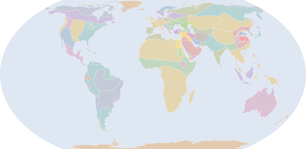
この年にページがある理由
年または日の単位で日付を持つ記録の、前年からの変化が最も大きい年の一つです:紀元前601年7月1日から紀元前600年7月1日までに21の名前が描かれ始めるか、描かれなくなります。
地図に描かれる名前
地図が書く名前で、描かれる輪郭の面積が大きい順に並べています。面積は描かれた輪郭のもので、丸めた概算です。「記録」はその輪郭を描く記録で、記録が Wikidata の項目を結んでいる場合はそれを示します。
| 名前 | 出典の綴り | 記録 | 描かれる面積(km²) |
|---|---|---|---|
| Khoiasan | historical-basemaps | 11,700,000 | |
| サハラの遊牧民 (出典による説明で、名前ではない) | Saharan pastoral nomads | historical-basemaps | 9,900,000 |
| オーストラリア先住民の狩猟採集民 (出典による説明で、名前ではない) | Australian aboriginal hunter-gatherers | historical-basemaps | 7,600,000 |
| 古シベリア系の狩猟採集民 (出典による説明で、名前ではない) | Paleo-Siberian hunter-gatherers | historical-basemaps | 7,170,000 |
| 西アフリカの穀作農耕民 (出典による説明で、名前ではない) | West African cereal farmers | historical-basemaps | 6,030,000 |
| 北極圏の海獣狩猟民 (出典による説明で、名前ではない) | Arctic marine mammal hunters | historical-basemaps | 5,910,000 |
| 原アルタイ系の牧畜民 (出典による説明で、名前ではない) | Proto-Altaic pastoralists | historical-basemaps | 4,990,000 |
| サバンナの狩猟採集民 (出典による説明で、名前ではない) | Savanna hunter-gatherers | historical-basemaps | 4,820,000 |
| キャッサバ農耕民 (出典による説明で、名前ではない) | Manioc farmers | historical-basemaps | 4,770,000 |
| 亜寒帯林の狩猟採集民 (出典による説明で、名前ではない) | Subarctic forest hunter-gatherers | historical-basemaps | 4,440,000 |
| カラスク文化 | Karasuk culture | historical-basemaps | 4,360,000 |
| アマゾンの狩猟採集民 (出典による説明で、名前ではない) | Amazon hunter-gatherers | historical-basemaps | 4,280,000 |
| 北米東部の狩猟採集民 (出典による説明で、名前ではない) | Eastern North Amercian hunter-gatherers | historical-basemaps | 3,600,000 |
| フィン・ウゴル系タイガの狩猟採集民 (出典による説明で、名前ではない) | Finno-Ugric taiga hunter-gatherers | historical-basemaps | 3,530,000 |
| Tibetans | historical-basemaps | 3,310,000 | |
| 平原のバイソン狩猟民 (出典による説明で、名前ではない) | Plain bison hunters | historical-basemaps | 2,850,000 |
| イラン系の牧畜民 (出典による説明で、名前ではない) | Iranian pastoralists | historical-basemaps | 2,840,000 |
| ヴェーダ期 | Vedic Aryans | historical-basemaps | 2,550,000 |
| アラビアの遊牧民 (出典による説明で、名前ではない) | Arabian pastoral nomads | historical-basemaps | 2,520,000 |
| 砂漠の狩猟採集民 (出典による説明で、名前ではない) | Desert hunter-gatherers | historical-basemaps | 2,350,000 |
| Median Kingdom | Cliopatria | 2,240,000 | |
| オーストロアジア系の稲作農耕民 (出典による説明で、名前ではない) | Austro-Asiatic rice farmers | historical-basemaps | 2,200,000 |
| パンパの諸文化 (出典による説明で、名前ではない) | Pampas cultures | historical-basemaps | 1,830,000 |
| Scythia | Cliopatria | 1,680,000 | |
| 骨壺墓地文化 (出典による説明で、名前ではない) | Urnfield cultures | historical-basemaps | 1,650,000 |
| 北ヨーロッパ青銅器時代の諸文化 (出典による説明で、名前ではない) | N. European Bronze Age cultures | historical-basemaps | 1,640,000 |
| Sinic | historical-basemaps | 1,630,000 | |
| トウモロコシ農耕民 (出典による説明で、名前ではない) | Maize farmers | historical-basemaps | 1,590,000 |
| Cimerians | historical-basemaps | 1,540,000 | |
| Austronesians | historical-basemaps | 1,280,000 | |
| Dravidians | historical-basemaps | 1,210,000 | |
| Berbers | historical-basemaps | 1,090,000 | |
| パプアの新石器農耕民 (出典による説明で、名前ではない) | Papuan neolithic farmers | historical-basemaps | 1,050,000 |
| Spring and Autumn States | Cliopatria | 1,010,000 | |
| Burmese | historical-basemaps | 961,000 | |
| アンデスの狩猟採集民 (出典による説明で、名前ではない) | Andean hunter-gatherers | historical-basemaps | 744,000 |
| 高原の漁労民・狩猟採集民 (出典による説明で、名前ではない) | Plateau fichers and hunter gatherers | historical-basemaps | 722,000 |
| 新バビロニア | Neo-Babylonian Empire | Cliopatria Q624887 | 704,000 |
| Saami | historical-basemaps | 631,000 | |
| ケルティベリア人 | Celtiberians | historical-basemaps | 548,000 |
| North American Pacifi foraging, hunting and fishing peoples | historical-basemaps | 533,000 | |
| カリブ海域の狩猟採集民 (出典による説明で、名前ではない) | Caribbean hunter-gatherers | historical-basemaps | 513,000 |
| エジプト第26王朝 | Twenty-sixth Dynasty of Egypt | Cliopatria Q662410 | 454,000 |
| Zhoa | historical-basemaps | 442,000 | |
| エラム | Elam | historical-basemaps | 389,000 |
| エチオピア高原の農耕民 (出典による説明で、名前ではない) | Ethiopian highland farmers | historical-basemaps | 376,000 |
| 原スキタイ文化 (出典による説明で、名前ではない) | Proto-Scythian culture | historical-basemaps | 367,000 |
| 楚 | Chu | Cliopatria Q504759 | 353,000 |
| 国家社会とアラム諸王国 (出典による説明で、名前ではない) | state societies and Aramaean kingdoms | historical-basemaps | 352,000 |
| クシュ | Kingdom of Kush | Cliopatria Q241790 | 337,000 |
全122の名前
| 名前 | 出典の綴り | 記録 | 描かれる面積(km²) |
|---|---|---|---|
| Arameans | historical-basemaps | 288,000 | |
| 縄文時代後期の文化 (出典による説明で、名前ではない) | Late Jomon culture | historical-basemaps | 281,000 |
| チェルノレス文化 | Chernoles culture | historical-basemaps | 279,000 |
| Chorrera | historical-basemaps | 262,000 | |
| パタゴニアの貝類・海獣狩猟民 (出典による説明で、名前ではない) | Patagonian shellfish and marine mammal hunters | historical-basemaps | 259,000 |
| リュディア | Lydia | Cliopatria Q620765 | 256,000 |
| Thrace | historical-basemaps | 256,000 | |
| 呉 | Wu | Cliopatria · historical-basemaps Q912068 | 245,000 |
| ルサチア文化 | Lusatian culture | historical-basemaps | 233,000 |
| イリュリア人 | Illyrians | historical-basemaps | 221,000 |
| ミログラード文化 | Milograd culture | historical-basemaps | 188,000 |
| Greek City-States | Cliopatria | 172,000 | |
| Ainu | historical-basemaps | 159,000 | |
| El Paraiso | historical-basemaps | 157,000 | |
| ウラルトゥ | Kingdom of Urartu | Cliopatria Q185068 | 155,000 |
| Paleo-Koreans | historical-basemaps | 150,000 | |
| 貝類採集民 (出典による説明で、名前ではない) | Shellfish gatherers | historical-basemaps | 149,000 |
| ヒッタイト | Hittites | historical-basemaps | 146,000 |
| 晋 | Jin | Cliopatria Q912043 | 137,000 |
| ウラルトゥ | Urartu | historical-basemaps | 108,000 |
| 斉 | Qi | Cliopatria Q837855 | 103,000 |
| シバ王国 | Saba | historical-basemaps | 99,900 |
| エジプト | Egypt | historical-basemaps | 97,600 |
| ハドラマウト | Hadhramaut | Cliopatria Q1517159 | 86,200 |
| Chavin | historical-basemaps | 82,900 | |
| 十六大国 | Mahajanapadas | Cliopatria Q846025 | 81,100 |
| ギリシアの都市国家 (出典による説明で、名前ではない) | Greek city-states | historical-basemaps | 72,800 |
| クシュ | Kush | historical-basemaps | 71,400 |
| タスマニアの狩猟採集民 (出典による説明で、名前ではない) | Tasmanian hunter-gatherers | historical-basemaps | 59,400 |
| 秦 | Qin | Cliopatria Q34756 | 56,500 |
| サバア王国 | Sabaeans | Cliopatria Q940785 | 55,500 |
| 燕 | Yan | Cliopatria Q1055713 | 49,700 |
| Olmec | historical-basemaps | 48,600 | |
| エトルリア人 | Etruscans | Cliopatria Q17161 | 48,100 |
| Chinchoros | historical-basemaps | 45,900 | |
| Phrygians | historical-basemaps | 45,100 | |
| 魯 | Lu | Cliopatria Q736936 | 43,600 |
| Kingdom of David and Solomon | historical-basemaps | 35,900 | |
| フェニキア | Phoenicia | Cliopatria Q41642 | 35,400 |
| フェニキア | Phoenician Empire | Cliopatria Q41642 | 35,100 |
| La Tène culture | historical-basemaps | 28,100 | |
| 宋 | Song | Cliopatria Q1065073 | 22,600 |
| バビロニア | Babylonia | historical-basemaps | 18,200 |
| Olmec Civilization | Cliopatria | 17,700 | |
| 古代カルタゴ | Carthage | Cliopatria Q2429397 | 12,400 |
| グアンチェ族 | Guanches | historical-basemaps | 9,080 |
| 衛 | Wey | Cliopatria Q1147897 | 7,020 |
| 邾 | Zhu | Cliopatria Q227007 | 6,650 |
| アンガ国 | Janapada of Anga | Cliopatria Q1155818 | 5,590 |
| マッラ国 | Janapada of Malla | Cliopatria Q1376303 | 5,500 |
| アッサカ国 | Janapada of Aśmaka | Cliopatria Q1194906 | 5,480 |
| マケドニア王国 | Macedonian Empire | Cliopatria Q83958 | 5,470 |
| 鄭 | Zheng | Cliopatria Q197598 | 5,280 |
| Janapada of Kuru | Cliopatria | 5,240 | |
| マツヤ国 | Janapada of Matsya | Cliopatria Q2665398 | 5,230 |
| シューラセーナ国 | Janapada of Surasena | Cliopatria Q1330149 | 5,200 |
| ヴァッジ国 | Janapada of Vajji | Cliopatria Q605199 | 5,170 |
| アヴァンティ国 | Janapada of Avanti | Cliopatria Q4827705 | 5,110 |
| Janapada of Kamboja | Cliopatria | 5,090 | |
| Chen | Cliopatria Q1069690 | 5,050 | |
| Janapada of Kāśī | Cliopatria | 5,050 | |
| マガダ国 | Janapada of Magadha | Cliopatria Q234009 | 5,050 |
| コーサラ国 | Janapada of Kosala | Cliopatria Q756854 | 5,000 |
| ガンダーラ人 | Janapada of Gandhāra | Cliopatria Q112980583 | 4,990 |
| パンチャーラ国 | Janapada of Pañcāla | Cliopatria Q558603 | 4,970 |
| 徐 | Xu | Cliopatria Q2650109 | 4,630 |
| Janapada of Cedī | Cliopatria | 4,400 | |
| 滕 | Teng | Cliopatria Q1356151 | 4,320 |
| ヴァツサ国 | Janapada of Vatsa | Cliopatria Q1331184 | 4,020 |
| 曹 | Cao | Cliopatria Q284964 | 4,010 |
| 蔡 | Cai | Cliopatria Q1025803 | 3,690 |
| 王政ローマ | Roman Kingdom | Cliopatria Q201038 | 857 |
紀元前700年からの変化
数えるのは、年または日の単位で日付を持つ記録(CShapes・OpenHistoricalMap・Cliopatria)の名前です。最も近い historical-basemaps の図から補った輪郭は、両方の年がその図の描かれた年であるときだけ数えます——そうでなければ、変化は2枚の図の切り替わりであって世界の変化ではないからです。名前は書かれたとおりに比べるので、記録が2つの年で別の名前で書く政体(Carthaginian Empire と Carthage など)は両方の欄に出ます。
新たに描かれる(25)
Median Kingdom、Scythia、新バビロニア、エジプト第26王朝、ウラルトゥ、十六大国、Olmec Civilization、古代カルタゴ、アンガ国、マッラ国、アッサカ国、マケドニア王国、Janapada of Kuru、マツヤ国、シューラセーナ国、ヴァッジ国、アヴァンティ国、Janapada of Kamboja、Janapada of Kāśī、マガダ国、コーサラ国、ガンダーラ人、パンチャーラ国、Janapada of Cedī、ヴァツサ国
描かれなくなった(4)
新アッシリア帝国、エラム、フリギア、Phoenician Colonies
紀元前600年の出来事
日付つき出来事の索引には、紀元前600年の出来事がありません。
出典と方法
国境と名前:Cliopatria v0.2.1 (Seshat Global History Databank, github.com/Seshat-Global-History-Databank/cliopatria) · CC BY 4.0 · adapted by IntMap: simplified, BC years made astronomical, and the ground OpenHistoricalMap (1689–1885, and from 1886 where CShapes is silent) and CShapes (1886–2019) state removed on their own dates + aourednik/historical-basemaps (github.com/aourednik/historical-basemaps) · GPL-3.0 · adapted by IntMap: each sheet before 1886 less the ground OpenHistoricalMap and Cliopatria state at that sheet's year。
どの年にページがあるかは、サイトのビルド時に記録そのものに3つの規則を当てて決めています:historical-basemaps の地図帳が世界図を描いたすべての年/前年からの変化(日付を持つ記録が描き始める・描かなくなる名前の数)が、日付を持つ記録が始まって以来の年ごとの変化の上位5%に入るすべての年(ある記録から別の記録へ引き継ぐ年は除く)/日付つき出来事の索引にある地政・戦争・革命の出来事のすべての年(国境の記録が覆う最後の年 2019 年まで)。
各年は7月1日で地図を読みます(アプリの年のリンクが開く瞬間)。名前は出典のもので、出典か IntMap の名前表に訳があるときは訳します。名前は記録が描くものであって、何が存在したかの判定ではありません。