500年の世界
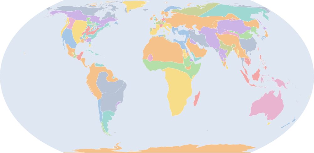
500年7月1日、IntMap の歴史地図は世界に136の名前を描きます。この日付の国境はSeshat Global History Databank の Cliopatria(年単位)、次にhistorical-basemaps(各記録は、前の記録が述べていない土地にだけ描く)によります。 このほか、この日付について記録が名前を与えていない輪郭を111描いています。
この年にページがある理由
historical-basemaps の地図帳がこの年の世界図を描いています。
地図に描かれる名前
地図が書く名前で、描かれる輪郭の面積が大きい順に並べています。面積は描かれた輪郭のもので、丸めた概算です。「記録」はその輪郭を描く記録で、記録が Wikidata の項目を結んでいる場合はそれを示します。
| 名前 | 出典の綴り | 記録 | 描かれる面積(km²) |
|---|---|---|---|
| Khoiasan | historical-basemaps | 11,200,000 | |
| オーストラリア先住民の狩猟採集民 (出典による説明で、名前ではない) | Australian aboriginal hunter-gatherers | historical-basemaps | 7,600,000 |
| 古シベリア系の狩猟採集民 (出典による説明で、名前ではない) | Paleo-Siberian hunter-gatherers | historical-basemaps | 7,170,000 |
| 北極圏の海獣狩猟民 (出典による説明で、名前ではない) | Arctic marine mammal hunters | historical-basemaps | 5,910,000 |
| 西アフリカの穀作農耕民 (出典による説明で、名前ではない) | West African cereal farmers | historical-basemaps | 5,570,000 |
| サバンナの狩猟採集民 (出典による説明で、名前ではない) | Savanna hunter-gatherers | historical-basemaps | 4,820,000 |
| アマゾンの狩猟採集民 (出典による説明で、名前ではない) | Amazon hunter-gatherers | historical-basemaps | 4,280,000 |
| 亜寒帯林の狩猟採集民 (出典による説明で、名前ではない) | Subarctic forest hunter-gatherers | historical-basemaps | 4,130,000 |
| 柔然 | Rouran Khaganate | Cliopatria Q155361 | 3,840,000 |
| フィン・ウゴル系タイガの狩猟採集民 (出典による説明で、名前ではない) | Finno-Ugric taiga hunter-gatherers | historical-basemaps | 3,530,000 |
| エフタル | White Huns | Cliopatria Q26576 | 3,300,000 |
| 平原のバイソン狩猟民 (出典による説明で、名前ではない) | Plain bison hunters | historical-basemaps | 2,790,000 |
| 斉 | Southern Qi | Cliopatria Q62456 | 2,370,000 |
| 砂漠の狩猟採集民 (出典による説明で、名前ではない) | Desert hunter-gatherers | historical-basemaps | 2,350,000 |
| Austronesian | historical-basemaps | 2,290,000 | |
| サーサーン朝 | Sasanian Empire | Cliopatria · historical-basemaps Q83891 | 2,210,000 |
| 東ローマ帝国 | Eastern Roman Empire | Cliopatria · historical-basemaps Q12544 | 2,150,000 |
| グリーンランド | Greenland | historical-basemaps | 1,860,000 |
| パンパの諸文化 (出典による説明で、名前ではない) | Pampas cultures | historical-basemaps | 1,830,000 |
| 北米東部の狩猟採集民 (出典による説明で、名前ではない) | Eastern North Amercian hunter-gatherers | historical-basemaps | 1,650,000 |
| グプタ朝 | Gupta Empire | Cliopatria · historical-basemaps Q11774 | 1,220,000 |
| 北魏 | Northern Wei | Cliopatria Q875305 | 1,170,000 |
| unclaimed | historical-basemaps | 1,050,000 | |
| Axum | historical-basemaps | 853,000 | |
| Hopewell Culture | historical-basemaps | 776,000 | |
| アンデスの狩猟採集民 (出典による説明で、名前ではない) | Andean hunter-gatherers | historical-basemaps | 744,000 |
| 高原の漁労民・狩猟採集民 (出典による説明で、名前ではない) | Plateau fichers and hunter gatherers | historical-basemaps | 722,000 |
| 西ゴート王国 | Visigothic Kingdom | Cliopatria Q126936 | 689,000 |
| ヴァーカータカ朝 | Vakataka Kingdom | Cliopatria Q1501306 | 674,000 |
| Saami | historical-basemaps | 617,000 | |
| 東ゴート王国 | Ostrogothic Kingdom | Cliopatria Q583038 | 555,000 |
| 吐谷渾 | Tuyuhun | Cliopatria Q1196201 | 554,000 |
| North American Pacifi foraging, hunting and fishing peoples | historical-basemaps | 533,000 | |
| カリブ海域の狩猟採集民 (出典による説明で、名前ではない) | Caribbean hunter-gatherers | historical-basemaps | 513,000 |
| 西域都護 | Protectorate of the Western Regions | Cliopatria Q911440 | 437,000 |
| ヒムヤル王国 | Himyarite Kingdom | Cliopatria · historical-basemaps Q289577 | 417,000 |
| Ruanruan | historical-basemaps | 410,000 | |
| 高句麗 | Goguryeo | Cliopatria Q28370 | 409,000 |
| 扶南国 | Funan | Cliopatria · historical-basemaps Q867782 | 400,000 |
| Scandinavian minor kingdoms | Cliopatria | 384,000 | |
| マヤ文明 | Mayan City-States | Cliopatria Q28567 | 380,000 |
| Laurel complex | historical-basemaps | 368,000 | |
| ガーナ王国 | Empire of Ghana | historical-basemaps | 335,000 |
| フランク王国 | Merovingian Empire | Cliopatria Q146246 | 305,000 |
| サリ族 | Salian Franks | Cliopatria Q939852 | 277,000 |
| ラフム朝 | Lakhmid Kingdom | Cliopatria Q943191 | 259,000 |
| パタゴニアの貝類・海獣狩猟民 (出典による説明で、名前ではない) | Patagonian shellfish and marine mammal hunters | historical-basemaps | 259,000 |
| ヴァンダル王国 | Vandal Kingdom | Cliopatria Q10416611 | 250,000 |
| ニュージーランド | New Zealand | historical-basemaps | 250,000 |
| Point Peninsula | historical-basemaps | 244,000 |
全136の名前
| 名前 | 出典の綴り | 記録 | 描かれる面積(km²) |
|---|---|---|---|
| Swift Creek Culture | historical-basemaps | 222,000 | |
| カダンバ朝 | Kadamba Empire | Cliopatria Q1479952 | 203,000 |
| Lavo | historical-basemaps | 194,000 | |
| Ainu | historical-basemaps | 159,000 | |
| 貝類採集民 (出典による説明で、名前ではない) | Shellfish gatherers | historical-basemaps | 149,000 |
| Marksville Culture | historical-basemaps | 149,000 | |
| ノバティア王国 | Nobatia | Cliopatria Q568523 | 148,000 |
| Maitraka Dynasty | Cliopatria Q6737189 | 145,000 | |
| アングロ・サクソン・イングランド | Anglo-Saxon England | Cliopatria Q784963 | 144,000 |
| カラブラ朝 | Kalabhra Dynasty | Cliopatria Q2572901 | 139,000 |
| Vandals | historical-basemaps | 138,000 | |
| カーマルーパ | Kamarupa Kingdom | Cliopatria Q1194765 | 130,000 |
| Brythons | Cliopatria | 129,000 | |
| Brythonic Kingdoms | Cliopatria | 129,000 | |
| 骨利幹 | Kurykans | historical-basemaps | 126,000 |
| アルワ王国 | Alodia | Cliopatria Q449639 | 124,000 |
| ブルグント王国 | Burgundian Kingdom | Cliopatria Q13590051 | 119,000 |
| Yamato | historical-basemaps | 119,000 | |
| ピュー | Pyu City-States | Cliopatria Q1627675 | 117,000 |
| Dorset | historical-basemaps | 112,000 | |
| アイスランド | Iceland | historical-basemaps | 101,000 |
| サクソン人 | Saxons | Cliopatria · historical-basemaps Q101985 | 101,000 |
| Moche | historical-basemaps | 98,500 | |
| アクスム王国 | Kingdom of Axum | Cliopatria Q139377 | 97,500 |
| ベラクルス文明 (出典による説明で、名前ではない) | Veracruz civilization | historical-basemaps | 92,700 |
| スエビ族のガリシア王国 | Kingdom of the Suebi | Cliopatria Q1048918 | 91,900 |
| Blemmyes | historical-basemaps | 88,900 | |
| Makkura | historical-basemaps | 87,900 | |
| カフカス・アルバニア王国 | Caucasian Albania | Cliopatria Q177076 | 74,900 |
| アヌラダープラ | Anurādhapura | Cliopatria Q5724 | 74,200 |
| チャンパ王国 | Chámpa | Cliopatria Q216786 | 73,100 |
| Fourche Maline Culture | historical-basemaps | 70,700 | |
| Zapotec Civilization | Cliopatria | 70,000 | |
| マクリア王国 | Makuria | Cliopatria Q829356 | 65,500 |
| タスマニアの狩猟採集民 (出典による説明で、名前ではない) | Tasmanian hunter-gatherers | historical-basemaps | 59,400 |
| Caloosahatchee cultureure | historical-basemaps | 59,100 | |
| フランク王国 | Kingdom of the Franks | Cliopatria Q146246 | 57,000 |
| Goodall Focus | historical-basemaps | 52,600 | |
| Couture Complex | historical-basemaps | 51,800 | |
| Porter | historical-basemaps | 50,500 | |
| Copena | historical-basemaps | 46,500 | |
| Kushan Principalities | historical-basemaps | 44,800 | |
| リプアリウス・フランク族 | Ripuarian Franks | Cliopatria Q316860 | 44,100 |
| Miller | historical-basemaps | 43,600 | |
| ナスカ市 | Nazca | historical-basemaps | 41,900 |
| Vishnu-Kundins | historical-basemaps | 41,700 | |
| Kingdom of Thuringia | Cliopatria | 40,400 | |
| Teotihuacàn | historical-basemaps | 38,800 | |
| パッラヴァ朝 | Late Pallava Empire | Cliopatria Q466803 | 38,100 |
| イベリア王国 | Caucasian Iberia | Cliopatria Q19083 | 35,700 |
| 百済 | Baekje | Cliopatria Q28428 | 34,900 |
| Saugeen Complex | historical-basemaps | 32,600 | |
| カダンバ朝 | Kadambas | historical-basemaps | 27,700 |
| Basks | historical-basemaps | 27,100 | |
| 西ガンガ朝 | Western Gangas | historical-basemaps | 25,600 |
| Mill Creek Culture | historical-basemaps | 25,400 | |
| ラジカ | Lazica | Cliopatria Q136884 | 24,500 |
| Tuʻi Tonga Empire | historical-basemaps | 24,200 | |
| 新羅 | Silla | Cliopatria · historical-basemaps Q28456 | 23,900 |
| Monte Albàn | historical-basemaps | 23,100 | |
| 東ゴート族 | Ostrogoths | historical-basemaps | 22,500 |
| タルマヌガラ王国 | Tarumanagara | Cliopatria Q2247225 | 17,800 |
| Vakataka | historical-basemaps | 16,600 | |
| ポバティ・ポイント文化 (出典による説明で、名前ではない) | Poverty point culture | historical-basemaps | 16,100 |
| チャンパ王国 | Champa | historical-basemaps | 14,800 |
| ランゴバルド人 | Lombards | Cliopatria Q130900 | 14,400 |
| マヤ諸国家 (出典による説明で、名前ではない) | Maya states | historical-basemaps | 8,350 |
| Visigoths | historical-basemaps | 7,600 | |
| テオティワカン | Teotihuacan | Cliopatria Q172613 | 5,690 |
| サセックス王国 | Kingdom of Sussex | Cliopatria Q676184 | 5,640 |
| ケント王国 | Kingdom of Kent | Cliopatria Q328818 | 4,400 |
| Sveves | historical-basemaps | 4,330 | |
| パッラヴァ朝 | Pallavas | historical-basemaps | 3,340 |
| Swedes | historical-basemaps | 3,070 | |
| Turingians | historical-basemaps | 2,380 | |
| 耽羅 | Tamna | Cliopatria Q28057 | 1,970 |
| Franks | historical-basemaps | 1,650 | |
| Toba Wei | historical-basemaps | 931 | |
| 百済 | Paekche | historical-basemaps | 855 |
| パーンディヤ朝 | Pandyas | historical-basemaps | 683 |
| Anglo-Saxons | historical-basemaps | 393 | |
| Cheras | historical-basemaps | 283 | |
| Hunnic Empire | Cliopatria | 197 | |
| Cholas | historical-basemaps | 123 | |
| Koguryo | historical-basemaps | 119 | |
| Armorica | historical-basemaps | 62.1 |
400年からの変化
数えるのは、年または日の単位で日付を持つ記録(CShapes・OpenHistoricalMap・Cliopatria)の名前です。最も近い historical-basemaps の図から補った輪郭は、両方の年がその図の描かれた年であるときだけ数えます——そうでなければ、変化は2枚の図の切り替わりであって世界の変化ではないからです。名前は書かれたとおりに比べるので、記録が2つの年で別の名前で書く政体(Carthaginian Empire と Carthage など)は両方の欄に出ます。
新たに描かれる(53)
柔然、エフタル、斉、Austronesian、グリーンランド、北米東部の狩猟採集民、unclaimed、西ゴート王国、東ゴート王国、Scandinavian minor kingdoms、フランク王国、ヴァンダル王国、ニュージーランド、Lavo、Maitraka Dynasty、アングロ・サクソン・イングランド、Brythons、Brythonic Kingdoms、骨利幹、ブルグント王国、Yamato、Dorset、アイスランド、ベラクルス文明、スエビ族のガリシア王国、Makkura、Caloosahatchee cultureure、フランク王国、Kushan Principalities、Vishnu-Kundins、Kingdom of Thuringia、Teotihuacàn、カダンバ朝、Basks、西ガンガ朝、Tuʻi Tonga Empire、Monte Albàn、Vakataka、ポバティ・ポイント文化、チャンパ王国、ランゴバルド人、マヤ諸国家、サセックス王国、ケント王国、Sveves、パッラヴァ朝、Turingians、Toba Wei、パーンディヤ朝、Anglo-Saxons、Cheras、Cholas、Armorica
描かれなくなった(37)
晋、西ローマ帝国、フン族、西クシャトラパ、Xionites、キダーラ朝、後燕、後秦、Meroe、五胡十六国時代、大晋、北涼、西秦、Paleo-Inuit、後涼、悦般、Hadramaut、Caucasian Alans、ヒンドゥー諸王国、Glades Culture、ペルシャ、烏孫、Teotihuacán、Southern Liang、イェート人、モンテ=アルバン、Norse、アレマン人、弁韓、ドゥムノニ族、グアンチェ族、マヤの首長国と諸国家、Burgunds、Angles、Hainan、Gaya、Akatziri
500年の出来事
日付つき出来事の索引には、500年の出来事がありません。
出典と方法
国境と名前:Cliopatria v0.2.1 (Seshat Global History Databank, github.com/Seshat-Global-History-Databank/cliopatria) · CC BY 4.0 · adapted by IntMap: simplified, BC years made astronomical, and the ground OpenHistoricalMap (1689–1885, and from 1886 where CShapes is silent) and CShapes (1886–2019) state removed on their own dates + aourednik/historical-basemaps (github.com/aourednik/historical-basemaps) · GPL-3.0 · adapted by IntMap: each sheet before 1886 less the ground OpenHistoricalMap and Cliopatria state at that sheet's year。
どの年にページがあるかは、サイトのビルド時に記録そのものに3つの規則を当てて決めています:historical-basemaps の地図帳が世界図を描いたすべての年/前年からの変化(日付を持つ記録が描き始める・描かなくなる名前の数)が、日付を持つ記録が始まって以来の年ごとの変化の上位5%に入るすべての年(ある記録から別の記録へ引き継ぐ年は除く)/日付つき出来事の索引にある地政・戦争・革命の出来事のすべての年(国境の記録が覆う最後の年 2019 年まで)。
各年は7月1日で地図を読みます(アプリの年のリンクが開く瞬間)。名前は出典のもので、出典か IntMap の名前表に訳があるときは訳します。名前は記録が描くものであって、何が存在したかの判定ではありません。