1868年の世界
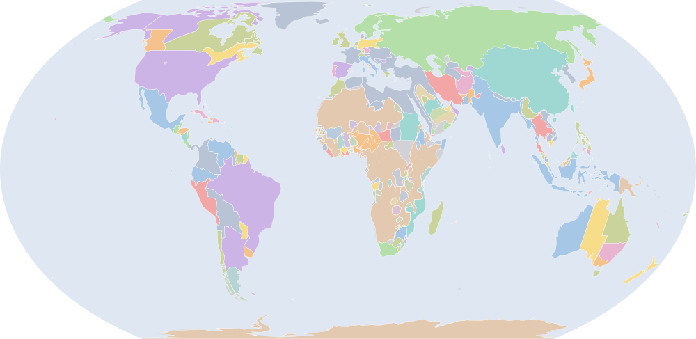
1868年7月1日、IntMap の歴史地図は世界に275の名前を描きます。この日付の国境はOpenHistoricalMap(日単位)、次にSeshat Global History Databank の Cliopatria(年単位)、次にhistorical-basemaps(各記録は、前の記録が述べていない土地にだけ描く)によります。 このほか、この日付について記録が名前を与えていない輪郭を11描いています。
この年にページがある理由
明治維新の年です(日付つき出来事の索引、Wikidata)。
地図に描かれる名前
地図が書く名前で、描かれる輪郭の面積が大きい順に並べています。面積は描かれた輪郭のもので、丸めた概算です。「記録」はその輪郭を描く記録で、記録が Wikidata の項目を結んでいる場合はそれを示します。
| 名前 | 出典の綴り | 記録 | 描かれる面積(km²) |
|---|---|---|---|
| ロシア帝国 | Russian Empire | OpenHistoricalMap · Cliopatria Q34266 | 21,700,000 |
| 大淸 | Qing | OpenHistoricalMap | 12,200,000 |
| アメリカ合衆国 | United States | OpenHistoricalMap | 9,820,000 |
| ブラジル帝国 | Empire of Brazil | OpenHistoricalMap | 8,130,000 |
| オスマン帝国 | Ottoman Empire | OpenHistoricalMap · Cliopatria · historical-basemaps Q1529261 Q12560 | 4,790,000 |
| イギリス領インド帝国 | British Raj (British India) | OpenHistoricalMap · Cliopatria Q129286 | 4,150,000 |
| ルパート・ランド | Rupert's Land | OpenHistoricalMap | 4,100,000 |
| ノースウエスト準州 | North-West Territories | OpenHistoricalMap | 2,990,000 |
| Colony of Western Australia | OpenHistoricalMap | 2,610,000 | |
| デンマーク | Denmark | OpenHistoricalMap | 2,540,000 |
| 南オーストラリア州 | Colony of South Australia | OpenHistoricalMap | 2,400,000 |
| オランダ領東インド | Dutch East Indies | OpenHistoricalMap | 2,280,000 |
| アルゼンチン | Argentina | OpenHistoricalMap | 2,160,000 |
| メキシコ | Mexico | OpenHistoricalMap | 2,030,000 |
| クイーンズランド植民地 | Colony of Queensland | OpenHistoricalMap | 1,800,000 |
| ボリビア | Bolivia | OpenHistoricalMap | 1,690,000 |
| ペルシャ | Persia | OpenHistoricalMap | 1,640,000 |
| コロンビア | Colombia | OpenHistoricalMap | 1,310,000 |
| ソコト帝国 | Sokoto Caliphate | OpenHistoricalMap · Cliopatria · historical-basemaps Q600524 | 1,200,000 |
| カナダ自治領 | Dominion of Canada | OpenHistoricalMap | 1,200,000 |
| エジプト副王領 | Khedivate of Egypt | Cliopatria Q127861 | 1,160,000 |
| アラビア | Arabia | historical-basemaps | 1,160,000 |
| フランス第二帝政 | Second French Empire | OpenHistoricalMap · Cliopatria · historical-basemaps Q71092 | 1,140,000 |
| ベネズエラ連邦 | United States of Venezuela | OpenHistoricalMap | 1,100,000 |
| ペルー | Peru | OpenHistoricalMap | 1,090,000 |
| ブリティッシュコロンビア植民地 | Colony of British Columbia | OpenHistoricalMap | 1,010,000 |
| スウェーデン=ノルウェー | Sweden–Norway | OpenHistoricalMap · historical-basemaps | 949,000 |
| British Arctic Territories | OpenHistoricalMap | 884,000 | |
| ニュー・サウスウェールズ植民地 | Colony of New South Wales | OpenHistoricalMap | 814,000 |
| モザンビーク州 | Province of Mozambique | OpenHistoricalMap | 811,000 |
| シャム | Siam | OpenHistoricalMap | 775,000 |
| 第二次サウード王国 | Emirate of Nejd | Cliopatria Q146862 | 773,000 |
| パラグアイ | Paraguay | OpenHistoricalMap | 690,000 |
| エクアドル | Ecuador | OpenHistoricalMap | 675,000 |
| Emirate of Afghanistan | OpenHistoricalMap | 642,000 | |
| オーストリア=ハンガリー帝国 | Austria-Hungary | OpenHistoricalMap | 638,000 |
| メリナ王国 | Kingdom of Imerina | OpenHistoricalMap | 626,000 |
| パンパの諸文化 (出典による説明で、名前ではない) | Pampas cultures | historical-basemaps | 586,000 |
| スペイン | Spain | OpenHistoricalMap | 529,000 |
| ケープ植民地 | Cape Colony | OpenHistoricalMap · historical-basemaps | 517,000 |
| 大日本帝国 | Empire of Japan (1868-1869) | OpenHistoricalMap | 510,000 |
| ヒヴァ・ハン国 | Khanate of Khiva | OpenHistoricalMap · Cliopatria Q491106 | 474,000 |
| 北ドイツ連邦 | North German Confederation | OpenHistoricalMap | 432,000 |
| イギリス帝国 | British Empire | Cliopatria Q8680 | 422,000 |
| ミャンマー | Burma | Cliopatria Q836 | 419,000 |
| Alawi Sultanate | OpenHistoricalMap | 392,000 | |
| グレートブリテン及びアイルランド連合王国 | United Kingdom of Great Britain and Ireland | OpenHistoricalMap | 383,000 |
| ワダイ王国 | Wadai Empire | Cliopatria · historical-basemaps Q1132786 | 379,000 |
| トゥクロール帝国 | Tukular Caliphate | historical-basemaps | 373,000 |
| チリ | Chile | OpenHistoricalMap · historical-basemaps | 349,000 |
全275の名前
| 名前 | 出典の綴り | 記録 | 描かれる面積(km²) |
|---|---|---|---|
| フィリピン総督領 | Captaincy General of the Philippines | OpenHistoricalMap | 348,000 |
| スペインによるフィリピンの植民地化 | Spanish Philippines | OpenHistoricalMap | 343,000 |
| エチオピア帝国 | Ethiopian Empire | Cliopatria · historical-basemaps Q207521 | 342,000 |
| イギリス領ニュージーランド | Colony of New Zealand | OpenHistoricalMap | 318,000 |
| Đại Nam | OpenHistoricalMap | 317,000 | |
| ウテテラ・スルタン国 | Sultanate of Utetera | historical-basemaps | 305,000 |
| イタリア王国 | Kingdom of Italy | OpenHistoricalMap | 301,000 |
| ダルフール・スルターン国 | Sultanate of Darfur | Cliopatria Q1474791 | 295,000 |
| トランスヴァール共和国 | South African Republic | OpenHistoricalMap · Cliopatria Q550374 | 292,000 |
| ザンジバル・スルタン国 | Sultinate of Zanzibar | historical-basemaps | 271,000 |
| 朝鮮(李氏朝鮮) | Joseon | OpenHistoricalMap | 268,000 |
| ヴィクトリア植民地 | Colony of Victoria | OpenHistoricalMap | 238,000 |
| カネム・ボルヌ帝国 | Bornu Empire | Cliopatria Q1139762 | 228,000 |
| ニューファンドランド直轄植民地 | Crown Colony of Newfoundland | OpenHistoricalMap | 227,000 |
| パタゴニアの貝類・海獣狩猟民 (出典による説明で、名前ではない) | Patagonian shellfish and marine mammal hunters | historical-basemaps | 227,000 |
| カラート藩王国 | Khanate of Kalat | OpenHistoricalMap | 219,000 |
| モシ諸王国 | Mossi States | historical-basemaps | 207,000 |
| コング帝国 | Kong Empire | historical-basemaps | 197,000 |
| オランダ王国 | Kingdom of the Netherlands | OpenHistoricalMap | 195,000 |
| イギリス帝国 | British Colonial Empire | Cliopatria Q8680 | 192,000 |
| マンギト朝 | Emirate of Bukhara | OpenHistoricalMap | 189,000 |
| ロジ | Lozi | historical-basemaps | 188,000 |
| イェケ王国 | Yeke | historical-basemaps | 187,000 |
| Shoshone | OpenHistoricalMap | 183,000 | |
| ウルグアイ | Uruguay | OpenHistoricalMap | 182,000 |
| ヌエバ・エスパーニャ | New Spain (1865-1899) | OpenHistoricalMap | 170,000 |
| ミランボの領域 | Mirambo Unyanyembe Ukimbu | historical-basemaps | 169,000 |
| Khanate of Kokand | OpenHistoricalMap | 159,000 | |
| キューバ総督領 | Captaincy General of Cuba | OpenHistoricalMap | 152,000 |
| ネパール | Nepal | OpenHistoricalMap | 148,000 |
| カネム・ボルヌ帝国 | Kanem-Bornu | historical-basemaps | 142,000 |
| エジプト | Egypt | historical-basemaps | 134,000 |
| オレンジ自由国 | Orange Free State | OpenHistoricalMap | 131,000 |
| ポルトガル王国 | Kingdom of Portugal | OpenHistoricalMap · Cliopatria Q45670 | 124,000 |
| Dendi Kingdom | historical-basemaps | 122,000 | |
| Apsáalooke people | OpenHistoricalMap | 122,000 | |
| ホンジュラス | Honduras | OpenHistoricalMap | 120,000 |
| マスカット・オマーン | Sultanate of Muscat and Oman | OpenHistoricalMap | 117,000 |
| マジェルテーン・スルタン国 | Majeerteen Sultanate | OpenHistoricalMap | 115,000 |
| ボルグ諸国 | Borgu States | historical-basemaps | 114,000 |
| ルンダ王国 | Kingdom of Lunda | Cliopatria Q1796223 | 110,000 |
| アシャンティ王国 | Ashanti Empire | Cliopatria Q722071 | 108,000 |
| スールー王国 | Sultanate of Sulu | OpenHistoricalMap | 107,000 |
| ニカラグア | Nicaragua | OpenHistoricalMap | 106,000 |
| ダル・エル・クティ | Sultanate of Dar al Kuti | OpenHistoricalMap | 100,000 |
| リベリア | Liberia | OpenHistoricalMap | 99,700 |
| バロツェ | Barotse | historical-basemaps | 97,600 |
| レッド・リバー・コロニー | Red River Colony | OpenHistoricalMap | 97,400 |
| グアテマラ | Guatemala | OpenHistoricalMap | 95,200 |
| マフラ首長国 | Sultanate of Qishn and Socotra | OpenHistoricalMap | 90,500 |
| Colony of Tasmania | OpenHistoricalMap | 87,800 | |
| フランス領ギアナ | Colony of French Guiana | OpenHistoricalMap | 86,600 |
| ジャバル・シャッマル王国 | Emirate of Jabal Shammar | Cliopatria Q5362837 | 84,400 |
| ギリシャ王国 | Kingdom of Greece | OpenHistoricalMap | 81,300 |
| ラゴス植民地 | Lagos Colony | OpenHistoricalMap | 81,300 |
| 休戦オマーン | Trucial States | OpenHistoricalMap | 80,900 |
| ショナ | Shona | historical-basemaps | 79,300 |
| イギリス領ギアナ | British Guiana | OpenHistoricalMap | 78,400 |
| シエラレオネ植民地および保護領 | Colony of Sierra Leone | OpenHistoricalMap | 76,500 |
| ルンダ王国 | Lunda | historical-basemaps | 76,300 |
| イギリス領セイロン | British Ceylon | OpenHistoricalMap | 75,700 |
| バイエルン王国 | Kingdom of Bavaria | OpenHistoricalMap | 75,700 |
| ンバイルンドゥ | Mbailundu | historical-basemaps | 72,700 |
| マラヤ | Malaya | historical-basemaps | 71,700 |
| ヤカ | Yaka | historical-basemaps | 67,500 |
| マギンダナオ王国 | Sultanate of Maguindanao | OpenHistoricalMap | 64,900 |
| Harer(エジプト) | Harer (Egypt) | historical-basemaps | 62,800 |
| French Africa | Cliopatria | 62,100 | |
| オヴィンブンドゥ | Ovimbundu | historical-basemaps | 61,000 |
| クバ王国 | Kuba | historical-basemaps | 60,900 |
| フランス領コーチシナ | Colony of Cochinchina | OpenHistoricalMap | 60,900 |
| コスタリカ | Costa Rica | OpenHistoricalMap | 60,100 |
| ンデベレ | Ndebele | historical-basemaps | 59,700 |
| ブニョロ王国 | Bunyoro | historical-basemaps | 58,900 |
| ブガンダ王国 | Buganda | historical-basemaps | 58,500 |
| 英領ゴールド・コースト | Gold Coast Colony | OpenHistoricalMap | 56,300 |
| ドミニカ共和国 | Dominican Republic | OpenHistoricalMap | 56,300 |
| テケ王国 | Teke | historical-basemaps | 56,000 |
| アンゴラ(ポルトガル) | Angola (Portugal) | historical-basemaps | 52,900 |
| ポルトガル領ギニア | Portuguese Guinea | OpenHistoricalMap · historical-basemaps | 51,800 |
| トランスヴァール共和国 | Transvaal | historical-basemaps | 48,600 |
| サラワク王国 | Kingdom of Sarawak | Cliopatria Q1658411 | 48,100 |
| モロッコ | Morocco | Cliopatria · historical-basemaps Q1028 | 47,800 |
| バハマ直轄植民地 | Colony of the Bahamas | OpenHistoricalMap | 47,200 |
| オマーン | Oman | historical-basemaps | 47,100 |
| ナタール植民地 | Colony of Natal | OpenHistoricalMap | 46,900 |
| セネガル(FR) | Senegal (FR) | historical-basemaps | 46,300 |
| バハーワルプル | Bahawalpur State | OpenHistoricalMap | 44,800 |
| ブルネイ帝国 | Sultanate of Brunei | Cliopatria Q887803 | 44,300 |
| フィジー | Confederacy of Independent Kingdoms of Fiji | OpenHistoricalMap | 43,400 |
| Wassoulou Empire | historical-basemaps | 43,200 | |
| Imamate of Yemen | Cliopatria | 42,900 | |
| Pahang Sultanate | Cliopatria | 41,300 | |
| スイス | Switzerland | OpenHistoricalMap | 41,200 |
| ルワンダ王国 | Kingdom of Rwanda | OpenHistoricalMap | 40,000 |
| ブータン | Bhutan | OpenHistoricalMap | 39,200 |
| セルビア公国 | Principality of Serbia | OpenHistoricalMap | 37,600 |
| ニューカレドニア | New Caledonia | OpenHistoricalMap | 36,500 |
| ハイチ共和国 | Republic of Haiti | OpenHistoricalMap | 35,700 |
| ングニ | Nguni | historical-basemaps | 35,400 |
| J'rai | OpenHistoricalMap | 35,100 | |
| Sultanate of Damagaram | historical-basemaps | 32,700 | |
| 英領ホンジュラス | British Honduras Colony | OpenHistoricalMap | 31,700 |
| モルディブ・スルターン国 | Sultanate of the Maldive Islands | OpenHistoricalMap | 31,300 |
| ポルトガル海上帝国 | Portuguese Empire | Cliopatria Q200464 | 31,000 |
| ケープ植民地 | British Cape Colony | Cliopatria Q370736 | 30,600 |
| フータ・ジャロン | Futa Jalon | historical-basemaps | 30,400 |
| Mosquito Reserve | OpenHistoricalMap | 30,200 | |
| ングワト | Ngwato | historical-basemaps | 30,000 |
| ベルギー | Belgium | OpenHistoricalMap | 29,900 |
| ハワイ王国 | Hawaiian Kingdom | OpenHistoricalMap | 28,600 |
| ブルンジ王国 | Kingdom of Burundi | OpenHistoricalMap | 26,900 |
| ズールーランド | Zululand | Cliopatria | 25,600 |
| People's Republic of Zanzibar | Cliopatria | 24,300 | |
| タイ帝国 | Rattanakosin Kingdom | Cliopatria Q1155700 | 24,200 |
| Sultanate of Perak | Cliopatria | 24,100 | |
| エルサルバドル | El Salvador | OpenHistoricalMap | 22,900 |
| マニプル王国 | Manipur State | OpenHistoricalMap | 22,400 |
| バストランド | Basutoland | historical-basemaps | 21,300 |
| 語る十字架 | Chan Santa Cruz | OpenHistoricalMap | 20,900 |
| ジョロフ王国 | Kingdom of Jolof | OpenHistoricalMap | 20,500 |
| ダホメ王国 | Kingdom of Dahomey | OpenHistoricalMap | 20,400 |
| ジョホール王国 | Sultanate of Johor | Cliopatria Q1150344 | 20,400 |
| Rabih az-Zubayr | historical-basemaps | 20,300 | |
| ガボン | Gabon | historical-basemaps | 19,700 |
| ヴュルテンベルク王国 | Württemberg | OpenHistoricalMap | 19,600 |
| ポルトガル領ティモール | Portuguese Timor | OpenHistoricalMap | 19,400 |
| ルバ王国 | Luba | historical-basemaps | 19,400 |
| ダホメ | Dahomey | historical-basemaps | 19,200 |
| コンゴ | Congo | historical-basemaps | 19,000 |
| Bundu | OpenHistoricalMap | 18,900 | |
| イギリス領モーリシャス | British Mauritius | OpenHistoricalMap | 16,000 |
| バーデン大公国 | Baden | OpenHistoricalMap | 15,200 |
| トレンガヌ州のスルターン | Sultanate of Terengganu | Cliopatria Q5769444 | 14,900 |
| コートジボワール | Ivory Coast | historical-basemaps | 14,900 |
| ジャマイカ植民地 | Colony of Jamaica | OpenHistoricalMap | 14,700 |
| アト交易連合 | Ato trading confederacy | historical-basemaps | 14,400 |
| カジョール王国 | Kingdom of Cayor | OpenHistoricalMap | 14,100 |
| スペイン領ギニア | Spanish Guinea | historical-basemaps | 13,600 |
| 教皇領 | Papal States | OpenHistoricalMap | 13,100 |
| プエルトリコ総督領 | Captaincy General of Puerto Rico | OpenHistoricalMap | 12,800 |
| スワジランド | Swaziland | historical-basemaps | 12,700 |
| カラバル | Calabar | historical-basemaps | 12,300 |
| Shoshone Indian Reservation | OpenHistoricalMap | 12,200 | |
| ベナン | Benin | historical-basemaps | 12,100 |
| Sultanate of Selangor | Cliopatria | 11,800 | |
| ガンビア植民地及び保護領 | Gambia Colony and Protectorate | OpenHistoricalMap | 11,700 |
| Kingdom of Niani | OpenHistoricalMap | 11,700 | |
| 西グリカランド | Griqualand West | historical-basemaps | 10,900 |
| Kingdom of Luang Phrabang | Cliopatria | 10,500 | |
| 琉球國 | Ryukyu Kingdom | OpenHistoricalMap | 10,500 |
| フータ・トロ | Futa Toro | historical-basemaps | 9,840 |
| プリンスエドワードアイランド州 | Prince Edward Island Colony | OpenHistoricalMap | 9,580 |
| クダ王国 | Sultanate of Kedah | Cliopatria Q1317579 | 9,370 |
| Algeria (FR) | historical-basemaps | 9,200 | |
| マプチェ族 | Mapuche | historical-basemaps | 9,010 |
| スペイン領ギニア | Spanish Posessions on the Gulf of Guinea | OpenHistoricalMap | 8,920 |
| クランタン州 | Kelantan | Cliopatria Q185944 | 8,610 |
| バオル王国 | Kingdom of Baol | OpenHistoricalMap | 8,170 |
| ラヘジュ首長国 | Sultanate of Lahej | OpenHistoricalMap | 8,120 |
| モザンビーク | Mozambique | historical-basemaps | 7,850 |
| Colony of Trinidad | OpenHistoricalMap | 7,680 | |
| Obock Colony | OpenHistoricalMap | 7,600 | |
| ザンジバル・スルターン国 | Sultanate of Zanzibar | OpenHistoricalMap | 7,260 |
| トルーシャル・オマーン | Trucial Oman | historical-basemaps | 7,050 |
| オポボ | Opobo | historical-basemaps | 7,000 |
| イギリス領ウィンドワード諸島 | British Windward Islands | OpenHistoricalMap | 6,910 |
| ルワンダ | Rwanda | historical-basemaps | 6,070 |
| Kingdom of Kakongo | OpenHistoricalMap | 6,050 | |
| ヌグリ・スンビラン州 | Negeri Sembilan | Cliopatria Q213893 | 5,930 |
| Kingdom of Wuli | OpenHistoricalMap | 5,410 | |
| 海峡植民地 | Colony of the Straits Settlement | OpenHistoricalMap | 5,240 |
| ナタール | Natal | historical-basemaps | 5,180 |
| オランダ領ゴールド・コースト | Dutch Gold Coast | Cliopatria Q770776 | 4,980 |
| グアドループ | Colony of Guadelupe | OpenHistoricalMap | 4,380 |
| ヘッセン大公国 | Hesse | OpenHistoricalMap | 4,360 |
| モンテネグロ公国 | Principality of Montenegro | OpenHistoricalMap | 4,310 |
| タークス・カイコス諸島直轄植民地 | Colony of the Turks and Caicos Islands | OpenHistoricalMap | 4,220 |
| レユニオン | La Réunion | OpenHistoricalMap | 3,930 |
| Kingdom of Ngoyo | OpenHistoricalMap | 3,920 | |
| テーサバーンナコーン・チエンマイ | Chiangmai | Cliopatria Q52028 | 3,310 |
| コトヌー | Cotonou | historical-basemaps | 3,260 |
| フランス領ポリネシア | Tahiti Protectorate | OpenHistoricalMap | 3,100 |
| サモア | Samoa | historical-basemaps | 2,960 |
| ルクセンブルク | Luxembourg | OpenHistoricalMap | 2,590 |
| ポルトガル領サントメ・プリンシペ | Portuguese São Tomé and Príncipe | OpenHistoricalMap | 2,560 |
| シヌ王国 | Kingdom of Sine | OpenHistoricalMap | 2,320 |
| バーレーン | Protectorate of Bahrain | OpenHistoricalMap | 2,180 |
| ラナオ王国 | Confederate States of Lanao | OpenHistoricalMap | 2,060 |
| ドイツ領カメルーン | Kamerun | Cliopatria | 1,940 |
| イフニ | Territory of Ifni | OpenHistoricalMap | 1,920 |
| デンマーク西インド諸島 | Danish West Indies | OpenHistoricalMap | 1,890 |
| ハウシャビー・スルターン国 | Haushabi Sultanate | OpenHistoricalMap | 1,860 |
| マヨット | Mayotte | OpenHistoricalMap | 1,620 |
| ウォルビスベイ | Walvis Bay Colony | OpenHistoricalMap | 1,610 |
| ドミニカ国 | Colony of Dominica | OpenHistoricalMap | 1,570 |
| ケイマン諸島 | Cayman Islands | OpenHistoricalMap | 1,520 |
| マン島 | Isle of Man | OpenHistoricalMap | 1,350 |
| Sultanate of Ndzuwani | OpenHistoricalMap | 1,260 | |
| French Nosy Be | OpenHistoricalMap | 1,110 | |
| サンピエール島・ミクロン島 | Saint Pierre and Miquelon | OpenHistoricalMap | 1,100 |
| ジャージー | Jersey | OpenHistoricalMap | 984 |
| 英国領マルタ | Crown Colony of Malta | OpenHistoricalMap | 925 |
| Sultanate of Mwali | OpenHistoricalMap | 923 | |
| ガーンジー | Guernsey | OpenHistoricalMap | 909 |
| サント・マリー島 | Nosy Boraha | OpenHistoricalMap | 888 |
| フランス領インド | French India | OpenHistoricalMap | 792 |
| ピトケアン諸島 | Pitcairn Islands | OpenHistoricalMap | 691 |
| ポルトガル領インド | Portuguese India | OpenHistoricalMap | 654 |
| ラブアン直轄植民地 | Colony of Labuan | OpenHistoricalMap | 638 |
| ブルネイ | Brunei | historical-basemaps | 612 |
| ダナン | French Tourane | OpenHistoricalMap | 590 |
| バミューダ植民地 | Colony of Bermuda | OpenHistoricalMap | 555 |
| セントヘレナ王領植民地 | Saint Helena Crown Colony | OpenHistoricalMap | 508 |
| アンドラ | Andorra | OpenHistoricalMap | 467 |
| ニウエ | Niue | historical-basemaps | 252 |
| 米領サモア | American Samoa | historical-basemaps | 234 |
| ポリネシア人 | Polynesians | historical-basemaps | 192 |
| ウォリス・フツナ | Wallis and Futuna Islands | historical-basemaps | 166 |
| イギリス領香港 | British Hong Kong | OpenHistoricalMap | 160 |
| ヘリゴランド | Heligoland | OpenHistoricalMap | 156 |
| リヒテンシュタイン | Liechtenstein | OpenHistoricalMap | 156 |
| サンマリノ | San Marino | OpenHistoricalMap | 60.1 |
| コウトミスト | Couto Misto | OpenHistoricalMap | 23.1 |
| モナコ | Monaco | OpenHistoricalMap | 17.9 |
1867年からの変化
数えるのは、年または日の単位で日付を持つ記録(CShapes・OpenHistoricalMap・Cliopatria)の名前です。最も近い historical-basemaps の図から補った輪郭は、両方の年がその図の描かれた年であるときだけ数えます——そうでなければ、変化は2枚の図の切り替わりであって世界の変化ではないからです。名前は書かれたとおりに比べるので、記録が2つの年で別の名前で書く政体(Carthaginian Empire と Carthage など)は両方の欄に出ます。
新たに描かれる(5)
大日本帝国、Shoshone Indian Reservation、オランダ領ゴールド・コースト、バーレーン、ドイツ領カメルーン
描かれなくなった(5)
スーダンの歴史、ロシア領アメリカ、江戸幕府、ポーランド王国、サルーム王国
1868年の出来事
IntMap の日付つき出来事の索引のうち、日付がこの年にあるすべての記録:国境の記録(CShapes 2.0)が自分の輪郭について述べていること、IntMap の戦争記録、Wikidata が日付を述べる世界の出来事——それぞれ出典と日付の精度つき。
- 1868
出典と方法
国境と名前:OpenHistoricalMap (openhistoricalmap.org) · CC0 1.0 + Cliopatria v0.2.1 (Seshat Global History Databank, github.com/Seshat-Global-History-Databank/cliopatria) · CC BY 4.0 · adapted by IntMap: simplified, BC years made astronomical, and the ground OpenHistoricalMap (1689–1885, and from 1886 where CShapes is silent) and CShapes (1886–2019) state removed on their own dates + aourednik/historical-basemaps (github.com/aourednik/historical-basemaps) · GPL-3.0 · adapted by IntMap: each sheet before 1886 less the ground OpenHistoricalMap and Cliopatria state at that sheet's year。
どの年にページがあるかは、サイトのビルド時に記録そのものに3つの規則を当てて決めています:historical-basemaps の地図帳が世界図を描いたすべての年/前年からの変化(日付を持つ記録が描き始める・描かなくなる名前の数)が、日付を持つ記録が始まって以来の年ごとの変化の上位5%に入るすべての年(ある記録から別の記録へ引き継ぐ年は除く)/日付つき出来事の索引にある地政・戦争・革命の出来事のすべての年(国境の記録が覆う最後の年 2019 年まで)。
各年は7月1日で地図を読みます(アプリの年のリンクが開く瞬間)。名前は出典のもので、出典か IntMap の名前表に訳があるときは訳します。名前は記録が描くものであって、何が存在したかの判定ではありません。