1807年の世界
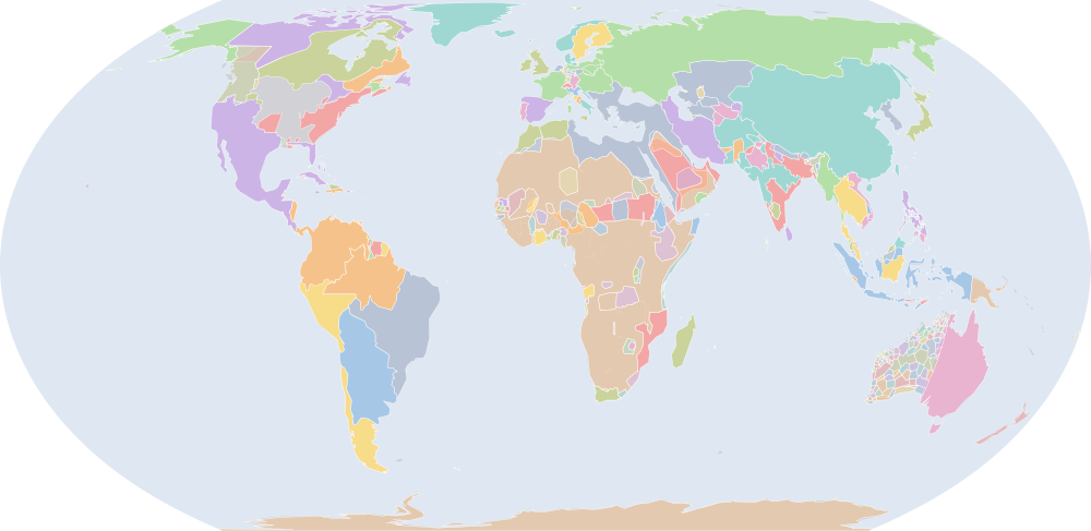
1807年7月1日、IntMap の歴史地図は世界に434の名前を描きます。この日付の国境はOpenHistoricalMap(日単位)、次にSeshat Global History Databank の Cliopatria(年単位)、次にhistorical-basemaps(各記録は、前の記録が述べていない土地にだけ描く)によります。 このほか、この日付について記録が名前を与えていない輪郭を10描いています。
この年にページがある理由
年または日の単位で日付を持つ記録の、前年からの変化が最も大きい年の一つです:1806年7月1日から1807年7月1日までに40の名前が描かれ始めるか、描かれなくなります。
地図に描かれる名前
地図が書く名前で、描かれる輪郭の面積が大きい順に並べています。面積は描かれた輪郭のもので、丸めた概算です。「記録」はその輪郭を描く記録で、記録が Wikidata の項目を結んでいる場合はそれを示します。
| 名前 | 出典の綴り | 記録 | 描かれる面積(km²) |
|---|---|---|---|
| ロシア帝国 | Russian Empire | OpenHistoricalMap · historical-basemaps | 18,200,000 |
| 大淸 | Qing | OpenHistoricalMap | 13,300,000 |
| ルパート・ランド | Rupert's Land | OpenHistoricalMap · historical-basemaps | 5,620,000 |
| ヌエバ・エスパーニャ | New Spain (1803-1809) | OpenHistoricalMap | 5,440,000 |
| エスタード・ド・ブラジル | State of Brazil | OpenHistoricalMap | 4,840,000 |
| オスマン帝国 | Ottoman Empire | OpenHistoricalMap · Cliopatria · historical-basemaps Q12560 | 4,570,000 |
| リオ・デ・ラ・プラタ副王領 | Viceroyalty of the Río de la Plata | OpenHistoricalMap | 4,160,000 |
| ニュー・サウスウェールズ植民地 | Colony of New South Wales | OpenHistoricalMap | 4,030,000 |
| ペルー副王領 | Viceroyalty of Peru | OpenHistoricalMap | 3,450,000 |
| ヌエバ・グラナダ副王領 | Viceroyalty of New Granada | OpenHistoricalMap | 3,070,000 |
| ノースウエスト準州 | North-West Territories | OpenHistoricalMap | 2,990,000 |
| デンマーク=ノルウェー | Denmark–Norway | OpenHistoricalMap | 2,970,000 |
| グラン・パラおよびリオ・ネグロ州 | State of Grão-Pará and Rio Negro | OpenHistoricalMap | 2,920,000 |
| カザフ・ハン国 | Kazakh Khanate | OpenHistoricalMap | 2,510,000 |
| オランダ領東インド | Dutch East Indies | OpenHistoricalMap | 2,230,000 |
| ガージャール朝イラン | Qajar Iran | OpenHistoricalMap | 1,840,000 |
| 第一次サウード王国 | Emirate of Diriyah | Cliopatria Q146871 | 1,800,000 |
| ロシア領アメリカ | Russian America | OpenHistoricalMap | 1,730,000 |
| Inner Provinces | OpenHistoricalMap | 1,690,000 | |
| アメリカ合衆国 | United States of America | Cliopatria Q30 | 1,360,000 |
| 会社領インド | Company Raj | OpenHistoricalMap | 1,300,000 |
| チリ総督領 | Captaincy General of Chile | OpenHistoricalMap | 1,300,000 |
| マラーター王国 | Maratha Confederacy | OpenHistoricalMap | 1,120,000 |
| ベネズエラ総督領 | Captaincy General of Venezuela | OpenHistoricalMap | 1,100,000 |
| ドゥッラーニー帝国 | Durrani Empire | Cliopatria Q467627 | 1,080,000 |
| タイ帝国 | Rattanakosin Kingdom Mandala | OpenHistoricalMap | 955,000 |
| ローワー・カナダ | Province of Lower Canada | OpenHistoricalMap | 933,000 |
| British Arctic Territories | OpenHistoricalMap | 884,000 | |
| スウェーデン | Sweden | OpenHistoricalMap | 840,000 |
| モザンビーク・ソファラ・セナ川総督領 | Captaincy-General of Mozambique, Sofala and Rivers of Sena | OpenHistoricalMap | 811,000 |
| フランス第一帝政 | French Republic (Empire) | OpenHistoricalMap | 667,000 |
| コンバウン王朝 | Konbaung Dynasty | Cliopatria Q1062422 | 644,000 |
| オーストリア帝国 | Austrian Empire | OpenHistoricalMap | 636,000 |
| メリナ王国 | Kingdom of Imerina | OpenHistoricalMap | 626,000 |
| Funj Sultanate | Cliopatria Q1475713 | 619,000 | |
| Oromo | historical-basemaps | 570,000 | |
| ソコト帝国 | Sokoto Caliphate | OpenHistoricalMap · Cliopatria Q600524 | 567,000 |
| イギリス帝国 | British Empire | Cliopatria Q8680 | 544,000 |
| スペイン | Spain | OpenHistoricalMap | 529,000 |
| 江戸幕府 | Tokugawa Shogunate | OpenHistoricalMap | 508,000 |
| コマンチェリア | Comancheria | OpenHistoricalMap | 486,000 |
| アルジェ摂政領 | Regency of Algiers | OpenHistoricalMap | 462,000 |
| ヒヴァ・ハン国 | Khanate of Khiva | OpenHistoricalMap · Cliopatria Q491106 | 454,000 |
| グアテマラ総督領 | Captaincy General of Guatemala | OpenHistoricalMap | 439,000 |
| Air | historical-basemaps | 416,000 | |
| セグー | Segu | historical-basemaps | 401,000 |
| アッパー・カナダ | Province of Upper Canada | OpenHistoricalMap | 395,000 |
| Nejd | historical-basemaps | 392,000 | |
| Alawi Sultanate | OpenHistoricalMap | 392,000 | |
| グレートブリテン及びアイルランド連合王国 | United Kingdom of Great Britain and Ireland | OpenHistoricalMap | 383,000 |
全434の名前
| 名前 | 出典の綴り | 記録 | 描かれる面積(km²) |
|---|---|---|---|
| バンジャル・スルタン王国 | Sultanate of Banjar | OpenHistoricalMap | 366,000 |
| プロイセン王国 | Kingdom of Prussia | OpenHistoricalMap | 355,000 |
| ルバ王国 | Luba | historical-basemaps | 353,000 |
| Hausa States | historical-basemaps | 350,000 | |
| マンギト朝 | Emirate of Bukhara | OpenHistoricalMap · Cliopatria Q746558 | 349,000 |
| フィリピン総督領 | Captaincy General of the Philippines | OpenHistoricalMap | 348,000 |
| スペインによるフィリピンの植民地化 | Spanish Philippines | OpenHistoricalMap | 343,000 |
| ラージプーターナー | Rajputana | OpenHistoricalMap | 343,000 |
| キューバ総督領 | Captaincy General of Cuba | OpenHistoricalMap | 342,000 |
| Đại Việt | OpenHistoricalMap | 326,000 | |
| カネム・ボルヌ帝国 | Bornu Empire | Cliopatria Q1139762 | 311,000 |
| ダルフール・スルターン国 | Sultanate of Darfur | Cliopatria Q1474791 | 296,000 |
| カアルタ | Kaarta | historical-basemaps | 286,000 |
| ケープ植民地 | British Cape Colony | Cliopatria Q370736 | 282,000 |
| ワダイ王国 | Wadai Empire | Cliopatria Q1132786 | 281,000 |
| ルンダ王国 | Lunda | historical-basemaps | 276,000 |
| ニューカレドニア | New Caledonia | OpenHistoricalMap | 275,000 |
| 朝鮮 | Joseon | OpenHistoricalMap | 268,000 |
| マオリ | M?ori | historical-basemaps | 250,000 |
| エチオピア帝国 | Ethiopian Empire | Cliopatria Q207521 | 241,000 |
| ヌエバ・ガリシア | New Galicia | OpenHistoricalMap | 230,000 |
| カラート藩王国 | Khanate of Kalat | OpenHistoricalMap | 219,000 |
| Zanzibar | historical-basemaps | 203,000 | |
| ユカタン総督領 | Intendency of Yucatán | OpenHistoricalMap | 198,000 |
| Funj | historical-basemaps | 193,000 | |
| スペイン帝国 | Spanish Empire | Cliopatria Q80702 | 184,000 |
| Shoshone | OpenHistoricalMap | 183,000 | |
| Mardu | historical-basemaps | 172,000 | |
| ピントゥピ族 | Pintupi | historical-basemaps | 163,000 |
| Khanate of Kokand | OpenHistoricalMap | 159,000 | |
| ネパール | Nepal | Cliopatria Q837 | 157,000 |
| アシャンティ王国 | Ashanti Empire | Cliopatria Q722071 | 151,000 |
| スリナム | Suriname | OpenHistoricalMap | 148,000 |
| モロッコ | Morocco | Cliopatria · historical-basemaps Q1028 | 146,000 |
| Watjarri | historical-basemaps | 144,000 | |
| シンド州 | Sind Sultanate | OpenHistoricalMap | 143,000 |
| ニューファンドランド植民地 | Newfoundland Colony | OpenHistoricalMap | 141,000 |
| Warlpiri | historical-basemaps | 140,000 | |
| バギルミ王国 | Bagirmi | historical-basemaps | 130,000 |
| Awsa | historical-basemaps | 124,000 | |
| Nyanganyatjara | historical-basemaps | 123,000 | |
| モシ諸王国 | Mossi States | historical-basemaps | 120,000 |
| オマーン帝国 | Omani Empire | OpenHistoricalMap | 118,000 |
| Mirning | historical-basemaps | 115,000 | |
| マジェルテーン・スルタン国 | Majeerteen Sultanate | OpenHistoricalMap | 115,000 |
| ルンダ王国 | Kingdom of Lunda | Cliopatria Q1796223 | 113,000 |
| Bornu-Kanem | historical-basemaps | 112,000 | |
| Rift Valley States | historical-basemaps | 112,000 | |
| ビルマ | Burma | historical-basemaps | 111,000 |
| Kokatha | historical-basemaps | 111,000 | |
| Zulu | historical-basemaps | 110,000 | |
| スールー王国 | Sultanate of Sulu | OpenHistoricalMap | 107,000 |
| ロズウィ王国 | Rozwi | historical-basemaps | 106,000 |
| ワルシャワ公国 | Duchy of Warsaw | OpenHistoricalMap | 106,000 |
| バンバラ王国 | Bamana Empire | Cliopatria Q762084 | 105,000 |
| Kalaamaya | historical-basemaps | 102,000 | |
| Nyangumarda | historical-basemaps | 101,000 | |
| ニュー・ブランズウィック植民地 | Colony of New Brunswick | OpenHistoricalMap | 99,900 |
| ダルフール | Darfur | historical-basemaps | 99,800 |
| イタリア王国 | Kingdom of Italy | OpenHistoricalMap | 94,000 |
| ポルトガル王国 | Kingdom of Portugal | OpenHistoricalMap | 93,300 |
| コング帝国 | Kong Empire | historical-basemaps | 92,700 |
| エチオピア | Ethiopia | historical-basemaps | 92,400 |
| マフラ首長国 | Sultanate of Qishn and Socotra | OpenHistoricalMap | 90,500 |
| フランス領ギアナ | Colony of French Guiana | OpenHistoricalMap | 86,600 |
| Wawula | historical-basemaps | 85,900 | |
| ナポリ王国 | Kingdom of Naples | OpenHistoricalMap | 85,700 |
| バイエルン王国 | Kingdom of Bavaria | Cliopatria Q154195 | 85,700 |
| アワド | Awadh | OpenHistoricalMap | 85,200 |
| マラヤ | Malaya | historical-basemaps | 85,100 |
| ロジ | Lozi | historical-basemaps | 81,000 |
| Ngatatjara | historical-basemaps | 77,000 | |
| Arrernte | historical-basemaps | 76,000 | |
| Ngaanyatjarra | historical-basemaps | 75,400 | |
| イギリス領セイロン | British Ceylon | OpenHistoricalMap | 73,800 |
| Mandjindja | historical-basemaps | 70,800 | |
| オヨ王国 | Oyo Empire | Cliopatria Q849623 | 70,100 |
| 中央アジアのハン国 | central Asian khanates | historical-basemaps | 69,000 |
| Wirangu | historical-basemaps | 68,500 | |
| Luritja | historical-basemaps | 68,100 | |
| Wangkathaa | historical-basemaps | 66,200 | |
| Yankuntjatjara | historical-basemaps | 66,000 | |
| マギンダナオ王国 | Sultanate of Maguindanao | OpenHistoricalMap | 64,900 |
| Pitjantjatjara | historical-basemaps | 64,200 | |
| Nakako | historical-basemaps | 64,000 | |
| Kalaako/Malpa | historical-basemaps | 63,800 | |
| シク王国 | Sikh Empire | Cliopatria Q83572 | 63,200 |
| ジョホール王国 | Sultanate of Johor | Cliopatria Q1150344 | 62,100 |
| オヨ王国 | Oyo | historical-basemaps | 60,500 |
| Warumungu | historical-basemaps | 58,600 | |
| Sotho | historical-basemaps | 57,200 | |
| ノバスコシア植民地 | Colony of Nova Scotia | OpenHistoricalMap | 56,900 |
| Yulparitja | historical-basemaps | 56,400 | |
| Ngarinyin | historical-basemaps | 55,600 | |
| ブータン | Bhutan | OpenHistoricalMap | 55,100 |
| Wudjari | historical-basemaps | 54,700 | |
| ポルトガル海上帝国 | Portuguese Empire | Cliopatria Q200464 | 53,800 |
| Rozvi | OpenHistoricalMap | 52,600 | |
| バハマ直轄植民地 | Colony of the Bahamas | OpenHistoricalMap | 51,400 |
| デンマーク=ノルウェー | Denmark-Norway | historical-basemaps | 49,500 |
| ハイチ共和国 | Republic of Haiti | OpenHistoricalMap | 49,500 |
| Antakarinja | historical-basemaps | 49,400 | |
| ブルネイ帝国 | Sultanate of Brunei | Cliopatria Q887803 | 48,200 |
| Kuwarra | historical-basemaps | 48,200 | |
| Kija | historical-basemaps | 47,900 | |
| ポルトガル領ティモール | Portuguese Timor | OpenHistoricalMap | 47,800 |
| Imamate of Futa Toro | OpenHistoricalMap | 47,000 | |
| ベルビセ植民地 | Colony of Berbice | OpenHistoricalMap | 46,500 |
| Tjupany | historical-basemaps | 46,400 | |
| Nyamal | historical-basemaps | 45,400 | |
| Ngarti | historical-basemaps | 44,900 | |
| バハーワルプル | Bahawalpur State | OpenHistoricalMap | 44,800 |
| Nyaki-nyaki | historical-basemaps | 44,800 | |
| Ngalea | historical-basemaps | 43,800 | |
| Xhosa | historical-basemaps | 43,000 | |
| ハイチ国 | State of Haiti | OpenHistoricalMap | 42,400 |
| ポルトガル領ギニア | Portuguese Guinea | OpenHistoricalMap | 41,700 |
| Mangala | historical-basemaps | 41,500 | |
| Jaru | historical-basemaps | 40,300 | |
| ルワンダ王国 | Kingdom of Rwanda | OpenHistoricalMap | 40,000 |
| ホラント王国 | Kingdom of Holland | OpenHistoricalMap | 39,300 |
| ムガル帝国 | Mughal Empire | Cliopatria Q33296 | 38,100 |
| Tjalkanti | historical-basemaps | 37,600 | |
| ザクセン王国 | Kingdom of Saxony | OpenHistoricalMap | 37,100 |
| Kukatja | historical-basemaps | 36,900 | |
| Warlmanpa | historical-basemaps | 36,900 | |
| Mudburra | historical-basemaps | 36,800 | |
| Kaytej | historical-basemaps | 36,400 | |
| J'rai | OpenHistoricalMap | 35,100 | |
| Walmatjarri | historical-basemaps | 34,800 | |
| Nana | historical-basemaps | 34,300 | |
| 教皇領 | Papal States | OpenHistoricalMap | 33,600 |
| Luisiana | historical-basemaps | 33,300 | |
| ヘルヴェティア連邦 | Swiss Confederation | OpenHistoricalMap | 33,200 |
| Gurindji | historical-basemaps | 32,700 | |
| オーストラリア先住民の狩猟採集民 (出典による説明で、名前ではない) | Australian aboriginal hunter-gatherers | historical-basemaps | 32,500 |
| Palyku | historical-basemaps | 32,400 | |
| Ngatjumay | historical-basemaps | 31,800 | |
| Nyikina | historical-basemaps | 31,700 | |
| シチリア王国 | Kingdom of Sicily | OpenHistoricalMap | 31,500 |
| Badimaya | historical-basemaps | 31,400 | |
| モルディブ・スルターン国 | Sultanate of the Maldive Islands | OpenHistoricalMap | 31,300 |
| Amangu | historical-basemaps | 28,400 | |
| アシャンティ王国 | Asante | historical-basemaps | 28,400 |
| ハワイ王国 | Hawaiian Kingdom | OpenHistoricalMap | 28,400 |
| Alawa | historical-basemaps | 27,300 | |
| サルデーニャ王国 | Kingdom of Sardinia | Cliopatria · historical-basemaps Q2577303 | 27,300 |
| ブルンジ王国 | Kingdom of Burundi | OpenHistoricalMap | 26,900 |
| Banjima | historical-basemaps | 25,700 | |
| Kurrama | historical-basemaps | 25,200 | |
| Ballardong | historical-basemaps | 25,200 | |
| オマーン | Sultanate of Oman | Cliopatria Q842 | 24,300 |
| Jawoyn | historical-basemaps | 24,200 | |
| Tuʻi Tonga Empire | historical-basemaps | 24,200 | |
| Anmatyerre | historical-basemaps | 24,200 | |
| Sultanate of Perak | Cliopatria | 23,900 | |
| Vice-Royalty of New Spain | historical-basemaps | 23,900 | |
| Yangman | historical-basemaps | 23,400 | |
| British Bencoolen | OpenHistoricalMap | 23,100 | |
| Wadai | historical-basemaps | 23,100 | |
| エトルリア王国 | Kingdom of Etruria | OpenHistoricalMap | 22,900 |
| Nhanta | historical-basemaps | 22,900 | |
| マニプル王国 | Manipur State | OpenHistoricalMap | 22,400 |
| Ngarinman | historical-basemaps | 22,000 | |
| Jingili | historical-basemaps | 21,700 | |
| Worla | historical-basemaps | 21,300 | |
| ルイジアナ中立地 | Louisiana Neutral Ground | OpenHistoricalMap | 20,600 |
| ジョロフ王国 | Kingdom of Jolof | OpenHistoricalMap | 20,500 |
| Yinggarda | historical-basemaps | 20,500 | |
| ダホメ王国 | Kingdom of Dahomey | OpenHistoricalMap | 20,400 |
| Wiilman | historical-basemaps | 20,200 | |
| Yuat | historical-basemaps | 19,500 | |
| Minang | historical-basemaps | 19,300 | |
| ガージャール朝 | Qajar Dynasty | Cliopatria Q189326 | 19,200 |
| Bundu | OpenHistoricalMap | 18,900 | |
| Ngalawangka | historical-basemaps | 18,800 | |
| Doolboong/Miriwoong | historical-basemaps | 18,400 | |
| 清 | Qing Empire | historical-basemaps | 17,600 |
| Maya | historical-basemaps | 17,400 | |
| サルーム王国 | Kingdom of Saloum | OpenHistoricalMap | 17,200 |
| ワルダマン族 | Wardaman | historical-basemaps | 17,100 |
| Kaniyang | historical-basemaps | 16,900 | |
| Yindjibarndi | historical-basemaps | 16,900 | |
| ヴュルテンベルク王国 | Kingdom of Württemberg | Cliopatria Q159631 | 16,800 |
| シルルク王国 | Shilluk Kingdom | OpenHistoricalMap | 16,800 |
| Thiin | historical-basemaps | 16,300 | |
| デメララ | Colony of Demerara | OpenHistoricalMap | 16,200 |
| Wagiman | historical-basemaps | 15,800 | |
| イエメン | Yemen | historical-basemaps | 15,800 |
| Colony of Cape Breton | OpenHistoricalMap | 15,600 | |
| Africa | historical-basemaps | 15,100 | |
| トレンガヌ州のスルターン | Sultanate of Terengganu | Cliopatria Q5769444 | 14,900 |
| ジャマイカ植民地 | Colony of Jamaica | OpenHistoricalMap | 14,700 |
| Principality of Thuận Thành | OpenHistoricalMap | 14,400 | |
| カジョール王国 | Kingdom of Cayor | OpenHistoricalMap | 14,100 |
| プエルトリコ総督領 | Captaincy General of Puerto Rico | OpenHistoricalMap | 14,100 |
| コンゴ | Congo | historical-basemaps | 14,000 |
| メクレンブルク=シュヴェリーン公国 | Duchy of Mecklenburg-Schwerin | OpenHistoricalMap | 13,900 |
| Nhuwala | historical-basemaps | 13,800 | |
| Goreng | historical-basemaps | 13,800 | |
| Yinhawangka | historical-basemaps | 13,500 | |
| バーデン大公国 | Grand Duchy of Baden | Cliopatria Q186320 | 13,500 |
| Unggumi | historical-basemaps | 13,300 | |
| Tharrgari | historical-basemaps | 13,200 | |
| Payungu | historical-basemaps | 13,200 | |
| Kariyarra | historical-basemaps | 12,400 | |
| Warriyangga | historical-basemaps | 12,100 | |
| Sultanate of Selangor | Cliopatria | 11,800 | |
| Kingdom of Niani | OpenHistoricalMap | 11,700 | |
| Jaminjung | historical-basemaps | 11,600 | |
| クダ王国 | Sultanate of Kedah | Cliopatria Q1317579 | 11,400 |
| オマーン | Oman | historical-basemaps | 11,300 |
| Ngalakan | historical-basemaps | 11,200 | |
| Thalanyji | historical-basemaps | 11,000 | |
| ヘッセン大公国 | Grand Duchy of Hesse | OpenHistoricalMap | 10,900 |
| 英領ホンジュラス | British Settlements on the Bay of Honduras | OpenHistoricalMap | 10,900 |
| Dutch settlements | historical-basemaps | 10,900 | |
| Gooniyandi | historical-basemaps | 10,800 | |
| マラーター王国 | Maratha Empire | Cliopatria Q83618 | 10,700 |
| Alyawarre | historical-basemaps | 10,700 | |
| ブンデールカンド | Bundelkhand | historical-basemaps | 10,600 |
| Kingdom of Luang Phrabang | Cliopatria | 10,500 | |
| 琉球國 | Ryukyu Kingdom | OpenHistoricalMap | 10,500 |
| エセキボ植民地 | Colony of Essequibo | OpenHistoricalMap | 10,500 |
| Bibbulman | historical-basemaps | 10,300 | |
| ベルク大公国 | Grand Duchy of Berg | OpenHistoricalMap · Cliopatria Q249428 | 9,840 |
| Purduna | historical-basemaps | 9,660 | |
| ラヘジュ首長国 | Sultanate of Lahej | OpenHistoricalMap | 9,630 |
| Wajuk | historical-basemaps | 9,620 | |
| プリンスエドワードアイランド州 | Prince Edward Island Colony | OpenHistoricalMap | 9,580 |
| Worora | historical-basemaps | 9,430 | |
| Malkana | historical-basemaps | 9,260 | |
| オランダ領ゴールド・コースト | Dutch Gold Coast | Cliopatria Q770776 | 9,120 |
| Rembarnga | historical-basemaps | 8,890 | |
| Karangpurru | historical-basemaps | 8,880 | |
| Karajarri | historical-basemaps | 8,820 | |
| クランタン州 | Kelantan | Cliopatria Q185944 | 8,610 |
| Bilinara | historical-basemaps | 8,540 | |
| Electorate of Hesse | OpenHistoricalMap | 8,510 | |
| Wunambul | historical-basemaps | 8,250 | |
| Sarawak | OpenHistoricalMap | 8,190 | |
| バオル王国 | Kingdom of Baol | OpenHistoricalMap | 8,170 |
| Warray | historical-basemaps | 8,160 | |
| Jiwarli | historical-basemaps | 7,940 | |
| Colony of Trinidad | OpenHistoricalMap | 7,680 | |
| フランス領フランス島 | Isle de France | OpenHistoricalMap | 7,530 |
| Gunwinggu | historical-basemaps | 7,220 | |
| デンマーク領黄金海岸 | Danish Gold Coast | OpenHistoricalMap | 6,910 |
| Dangbon | historical-basemaps | 6,770 | |
| イオニア七島連邦国 | Septinsular Republic | OpenHistoricalMap | 6,730 |
| Kungarakany | historical-basemaps | 6,580 | |
| Kwini | historical-basemaps | 6,510 | |
| Jurruru | historical-basemaps | 6,430 | |
| Kingdom of Kakongo | OpenHistoricalMap | 6,050 | |
| パルマ・エ・ピアチェンツァ公国 | Duchy of Parma and Piacenza | OpenHistoricalMap | 6,030 |
| Ngan’giwumirri | historical-basemaps | 5,970 | |
| ヌグリ・スンビラン州 | Negeri Sembilan | Cliopatria Q213893 | 5,930 |
| Kadjerong | historical-basemaps | 5,910 | |
| Punuba | historical-basemaps | 5,830 | |
| Pinikura | historical-basemaps | 5,780 | |
| スペイン領ギニア | Spanish Possessions on the Gulf of Guinea | OpenHistoricalMap | 5,750 |
| イギリス帝国 | British Colonial Empire | Cliopatria Q8680 | 5,690 |
| Nimanburu | historical-basemaps | 5,640 | |
| ワーロ | Kingdom of Waalo | OpenHistoricalMap | 5,570 |
| オルデンブルク | Duchy of Oldenburg | OpenHistoricalMap | 5,530 |
| Kingdom of Wuli | OpenHistoricalMap | 5,410 | |
| イギリス領ギアナ | British Guiana | OpenHistoricalMap | 5,330 |
| Mangarayi | historical-basemaps | 5,240 | |
| ロダン共和国 | Valais Republic | OpenHistoricalMap | 5,210 |
| Wuningangk | historical-basemaps | 5,100 | |
| フランス第一帝政 | First French Empire | Cliopatria Q71084 | 4,980 |
| Ngarluma | historical-basemaps | 4,950 | |
| レーゲンスブルク公国 | Principality of Regensberg | Cliopatria Q701969 | 4,940 |
| Nawu | historical-basemaps | 4,680 | |
| Martuthunira | historical-basemaps | 4,600 | |
| Warwa | historical-basemaps | 4,520 | |
| Malak malak | historical-basemaps | 4,500 | |
| Yawuru | historical-basemaps | 4,500 | |
| レユニオン | La Réunion | OpenHistoricalMap | 4,490 |
| Ngaliwuru | historical-basemaps | 4,410 | |
| グアドループ | Colony of Guadelupe | OpenHistoricalMap | 4,380 |
| Limilngan | historical-basemaps | 4,370 | |
| ツルナ・ゴーラ府主教領 | Prince-Bishopric of Montenegro | OpenHistoricalMap | 4,310 |
| ダホメ | Dahomey | historical-basemaps | 4,180 |
| コダグ王国 | Kingdom of Coorg | OpenHistoricalMap | 4,130 |
| Miwa | historical-basemaps | 3,950 | |
| Kingdom of Ngoyo | OpenHistoricalMap | 3,920 | |
| Woolna | historical-basemaps | 3,910 | |
| Ngumbarl | historical-basemaps | 3,850 | |
| Wardandi | historical-basemaps | 3,820 | |
| Gamberre | historical-basemaps | 3,730 | |
| Nungali | historical-basemaps | 3,720 | |
| Larrakia | historical-basemaps | 3,720 | |
| Murrinh-patha | historical-basemaps | 3,620 | |
| Ngalkbun | historical-basemaps | 3,510 | |
| フランス領インド | French India | OpenHistoricalMap · Cliopatria Q646374 | 3,280 |
| Ngarla | historical-basemaps | 3,190 | |
| アーレンベルク=メッペン公領 | Duchy of Arenberg-Meppen | OpenHistoricalMap | 3,060 |
| Umida | historical-basemaps | 2,990 | |
| ラグサ共和国 | Republic of Ragusa | OpenHistoricalMap | 2,980 |
| ロイス=ゲーラ侯国 | Principality of Reuss-Gera | OpenHistoricalMap · Cliopatria Q639100 | 2,840 |
| ヴュルツブルク大公国 | Grand Duchy of Würzburg | Cliopatria Q698089 | 2,770 |
| Jabirrjabirr | historical-basemaps | 2,740 | |
| Yiiji | historical-basemaps | 2,700 | |
| ルッカ・エ・ピオンビーノ公国 | Principality of Lucca and Piombino | OpenHistoricalMap | 2,650 |
| Duchy of Mecklenburg-Strelitz | OpenHistoricalMap | 2,630 | |
| Iwaidja | historical-basemaps | 2,590 | |
| Ngandji | historical-basemaps | 2,570 | |
| ポルトガル領サントメ・プリンシペ | Portuguese São Tomé and Príncipe | OpenHistoricalMap | 2,560 |
| Arakan | historical-basemaps | 2,520 | |
| シヌ王国 | Kingdom of Sine | OpenHistoricalMap | 2,320 |
| Amarak | historical-basemaps | 2,200 | |
| Sultanate of Ndzuwani | OpenHistoricalMap | 2,180 | |
| アシャッフェンブルク侯領 | Principality of Aschaffenburg | OpenHistoricalMap | 2,120 |
| ラナオ王国 | Confederate States of Lanao | OpenHistoricalMap | 2,060 |
| セントビンセント・グレナディーン | Colony of St Vincent and the Grenadines | OpenHistoricalMap | 2,030 |
| Unggarangi | historical-basemaps | 1,980 | |
| デンマーク西インド諸島 | Danish West Indies | OpenHistoricalMap | 1,890 |
| ハウシャビー・スルターン国 | Haushabi Sultanate | OpenHistoricalMap | 1,860 |
| Marrithiyel | historical-basemaps | 1,810 | |
| Pinjarup | historical-basemaps | 1,800 | |
| Jukun | historical-basemaps | 1,780 | |
| Gagudju | historical-basemaps | 1,760 | |
| Kundjey’mi | historical-basemaps | 1,680 | |
| Sultanate of Maore | OpenHistoricalMap | 1,620 | |
| ウォルビスベイ | Walvis Bay Colony | OpenHistoricalMap | 1,610 |
| ルッカ | Lucca | historical-basemaps | 1,600 |
| ドミニカ国 | Colony of Dominica | OpenHistoricalMap | 1,570 |
| ケイマン諸島 | Cayman Islands | OpenHistoricalMap | 1,520 |
| Nyul Nyul | historical-basemaps | 1,510 | |
| グレナダ | Colony of Grenada | OpenHistoricalMap | 1,480 |
| Marringarr | historical-basemaps | 1,390 | |
| Colony of Saint Lucia | OpenHistoricalMap | 1,360 | |
| マン島 | Isle of Man | OpenHistoricalMap | 1,350 |
| Konbudj | historical-basemaps | 1,330 | |
| Mbukarla | historical-basemaps | 1,240 | |
| リッペ侯国 | Principality of Lippe | OpenHistoricalMap | 1,210 |
| Ngombur | historical-basemaps | 1,170 | |
| カフルール | Kahlur State | OpenHistoricalMap | 1,170 |
| シュヴァルツブルク=ルードルシュタット侯国 | Principality of Schwarzburg-Rudolstadt | OpenHistoricalMap | 1,080 |
| ヴァルデック侯国 | Waldeck | OpenHistoricalMap | 1,050 |
| バルバドス | Colony of Barbados | OpenHistoricalMap | 1,020 |
| トバゴ島 | Colony of Tobago | OpenHistoricalMap | 1,020 |
| ジャージー | Jersey | OpenHistoricalMap | 984 |
| シュヴァルツブルク=ゾンダースハウゼン侯国 | Principality of Schwarzburg-Sondershausen | OpenHistoricalMap | 935 |
| マルタ保護国 | British Protectorate of Malta | OpenHistoricalMap | 925 |
| ガーンジー | Guernsey | OpenHistoricalMap | 909 |
| Hohenzollern-Sigmaringen | OpenHistoricalMap | 902 | |
| アンハルト=デッサウ公国 | Duchy of Anhalt-Dessau | OpenHistoricalMap | 888 |
| アンハルト=ベルンブルク公国 | Duchy of Anhalt-Bernburg | OpenHistoricalMap | 809 |
| Maranunggu | historical-basemaps | 797 | |
| Principality of Neuchâtel | OpenHistoricalMap | 791 | |
| Principality Isenburg | OpenHistoricalMap | 763 | |
| Ngan’gikurunggurr | historical-basemaps | 759 | |
| アンハルト=ケーテン公国 | Duchy of Anhalt-Köthen | OpenHistoricalMap | 682 |
| ポルトガル領インド | Portuguese India | OpenHistoricalMap | 654 |
| Gunbalang | historical-basemaps | 653 | |
| ケープ植民地 | Cape Colony | historical-basemaps | 625 |
| Gungurugoni | historical-basemaps | 612 | |
| ダナン | French Tourane | OpenHistoricalMap | 590 |
| バミューダ植民地 | Colony of Bermuda | OpenHistoricalMap | 555 |
| セントヘレナ植民地 | Saint Helena Colony | OpenHistoricalMap | 508 |
| Maung | historical-basemaps | 487 | |
| アンドラ | Andorra | OpenHistoricalMap | 467 |
| Bukurnidja | historical-basemaps | 410 | |
| Marramaninjsji | historical-basemaps | 409 | |
| Gunibidji | historical-basemaps | 394 | |
| シャウムブルク=リッペ侯国 | Schaumburg-Lippe | OpenHistoricalMap | 341 |
| ロイス=グライツ侯国 | Principality of Reuss-Greiz | OpenHistoricalMap | 312 |
| Kuwema | historical-basemaps | 303 | |
| Bardi | historical-basemaps | 249 | |
| ホーエンツォレルン=ヘッヒンゲン家 | Hohenzollern-Hechingen | OpenHistoricalMap | 228 |
| レーゲンスブルク公国 | Principality of Regensburg | OpenHistoricalMap | 205 |
| ポリネシア人 | Polynesians | historical-basemaps | 192 |
| リヒテンシュタイン | Liechtenstein | OpenHistoricalMap | 156 |
| Burarra | historical-basemaps | 112 | |
| Nakara | historical-basemaps | 99.3 | |
| Tjerratj | historical-basemaps | 93.9 | |
| コロニア・デル・サクラメント | Sacramento Colony | OpenHistoricalMap | 85.7 |
| ライエン侯国 | Principality of Leyen | OpenHistoricalMap | 72.8 |
| Pyrmont | OpenHistoricalMap | 65.2 | |
| サンマリノ | San Marino | OpenHistoricalMap | 60.1 |
| コウトミスト | Couto Misto | OpenHistoricalMap | 23.1 |
| Jaburrara | historical-basemaps | 3.38 |
1800年からの変化
数えるのは、年または日の単位で日付を持つ記録(CShapes・OpenHistoricalMap・Cliopatria)の名前です。最も近い historical-basemaps の図から補った輪郭は、両方の年がその図の描かれた年であるときだけ数えます——そうでなければ、変化は2枚の図の切り替わりであって世界の変化ではないからです。名前は書かれたとおりに比べるので、記録が2つの年で別の名前で書く政体(Carthaginian Empire と Carthage など)は両方の欄に出ます。
新たに描かれる(53)
ヌエバ・エスパーニャ、アメリカ合衆国、フランス第一帝政、オーストリア帝国、ソコト帝国、グレートブリテン及びアイルランド連合王国、Đại Việt、ニューカレドニア、ワルシャワ公国、イタリア王国、バイエルン王国、シク王国、ハイチ共和国、ハイチ国、ホラント王国、ザクセン王国、ヘルヴェティア連邦、エトルリア王国、ルイジアナ中立地、ヴュルテンベルク王国、メクレンブルク=シュヴェリーン公国、バーデン大公国、ヘッセン大公国、ベルク大公国、Electorate of Hesse、オルデンブルク、ロダン共和国、フランス第一帝政、レーゲンスブルク公国、アーレンベルク=メッペン公領、ロイス=ゲーラ侯国、ヴュルツブルク大公国、ルッカ・エ・ピオンビーノ公国、Duchy of Mecklenburg-Strelitz、アシャッフェンブルク侯領、リッペ侯国、シュヴァルツブルク=ルードルシュタット侯国、ヴァルデック侯国、シュヴァルツブルク=ゾンダースハウゼン侯国、マルタ保護国、Hohenzollern-Sigmaringen、アンハルト=デッサウ公国、アンハルト=ベルンブルク公国、Principality of Neuchâtel、Principality Isenburg、アンハルト=ケーテン公国、シャウムブルク=リッペ侯国、ロイス=グライツ侯国、ホーエンツォレルン=ヘッヒンゲン家、レーゲンスブルク公国、リヒテンシュタイン、ライエン侯国、Pyrmont
描かれなくなった(25)
ヌエバ・エスパーニャ、アメリカ合衆国、ハプスブルク君主国、フランス第一共和政、神聖ローマ帝国、グレートブリテン王国、大越 (タイソン朝)、ティドレ王国、カルナータカ太守、アイルランド王国、Qasimids、サン=ドマング、塘中、カルトリ・カヘティ王国、バタヴィア共和国、ヘルヴェティア共和国、チザルピーナ共和国、テーサバーンナコーン・チエンマイ、タイ帝国、トスカーナ大公国、統領政府、カンボジア、ピオンビーノ侯国、ルッカ共和国、フランスによるマルタ占領
1807年の出来事
日付つき出来事の索引には、1807年の出来事がありません。
出典と方法
国境と名前:OpenHistoricalMap (openhistoricalmap.org) · CC0 1.0 + Cliopatria v0.2.1 (Seshat Global History Databank, github.com/Seshat-Global-History-Databank/cliopatria) · CC BY 4.0 · adapted by IntMap: simplified, BC years made astronomical, and the ground OpenHistoricalMap (1689–1885, and from 1886 where CShapes is silent) and CShapes (1886–2019) state removed on their own dates + aourednik/historical-basemaps (github.com/aourednik/historical-basemaps) · GPL-3.0 · adapted by IntMap: each sheet before 1886 less the ground OpenHistoricalMap and Cliopatria state at that sheet's year。
どの年にページがあるかは、サイトのビルド時に記録そのものに3つの規則を当てて決めています:historical-basemaps の地図帳が世界図を描いたすべての年/前年からの変化(日付を持つ記録が描き始める・描かなくなる名前の数)が、日付を持つ記録が始まって以来の年ごとの変化の上位5%に入るすべての年(ある記録から別の記録へ引き継ぐ年は除く)/日付つき出来事の索引にある地政・戦争・革命の出来事のすべての年(国境の記録が覆う最後の年 2019 年まで)。
各年は7月1日で地図を読みます(アプリの年のリンクが開く瞬間)。名前は出典のもので、出典か IntMap の名前表に訳があるときは訳します。名前は記録が描くものであって、何が存在したかの判定ではありません。